The N14 postcode district is a postal district located in the N London - N postcode area with a population of 31,422 residents according to the 2021 England and Wales Census.
The area of the N14 postcode district is 2.77 square miles which is 7.18 square kilometres or 1,773.48 acres.
Currently, the N14 district has about 691 postcode units spread across 4 geographic postcode sectors.
Given that each sector allows for 400 unique postcode combinations, the district has a capacity of 1,600 postcodes. With 691 postcodes already in use, this leaves 909 units available.
The largest settlements in the N14 postal code are SOUTHGATE and NEW SOUTHGATE.
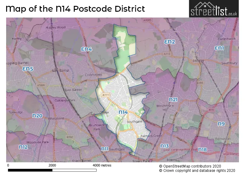
The N14 Postcode shares a border with EN4 (EAST BARNET, NEW BARNET, ENFIELD), N11 (NEW SOUTHGATE, SOUTHGATE, WOOD GREEN), N13 (SOUTHGATE), N21 (SOUTHGATE) and EN2 (ENFIELD).
The primary settlement in the N14 postcode district is Enfield, located in the county of Greater London in England. The other significant settlement in this district is Barnet. The main post town within the N14 postcode district is London.
For the district N14, we have data on 5 postcode sectors. Here's a breakdown: The sector N14 4, covers Enfield in Greater London. The sector N14 5, covers Barnet and Enfield in Greater London. The sector N14 6, covers Enfield in Greater London. The sector N14 7, covers Enfield and Barnet in Greater London. The sector N14 9 is non-geographic. It's often designated for PO Boxes, large organisations, or special services.

Map of the N14 Postcode District
Explore the N14 postcode district by using our free interactive map.
When it comes to local government, postal geography often disregards political borders. However, for a breakdown in the N14 District: the district mostly encompasses the Enfield London Boro (550 postcodes), and finally, the Barnet London Boro area (136 postcodes).
Recent House Sales in N14
| Date | Price | Address |
|---|---|---|
| 14/09/2023 | £420,000 | Chase Side, London, N14 4PJ |
| 07/09/2023 | £350,000 | Chase Road, London, N14 4RA |
| 01/09/2023 | £755,000 | Hood Avenue, London, N14 4QJ |
| 31/08/2023 | £460,000 | Chase Road, London, N14 4RE |
| 31/08/2023 | £650,000 | Chase Road, London, N14 4ET |
| 29/08/2023 | £860,000 | Winchmore Hill Road, London, N14 6PY |
| 25/08/2023 | £710,000 | Hampden Way, London, N14 5AY |
| 25/08/2023 | £385,000 | Park Road, London, N14 6HB |
| 25/08/2023 | £547,000 | Trent Gardens, London, N14 4QL |
| 25/08/2023 | £775,000 | Sheringham Avenue, London, N14 4UG |
Weather Forecast for N14
Press Button to Show Forecast for Wood Green
| Time Period | Icon | Description | Temperature | Rain Probability | Wind |
|---|---|---|---|---|---|
| 06:00 to 09:00 | Cloudy | 5.0°C (feels like 2.0°C) | 4.00% | NE 7 mph | |
| 09:00 to 12:00 | Partly cloudy (day) | 8.0°C (feels like 6.0°C) | 2.00% | ENE 7 mph | |
| 12:00 to 15:00 | Cloudy | 11.0°C (feels like 9.0°C) | 9.00% | E 4 mph | |
| 15:00 to 18:00 | Overcast | 11.0°C (feels like 10.0°C) | 14.00% | ENE 7 mph | |
| 18:00 to 21:00 | Cloudy | 10.0°C (feels like 9.0°C) | 11.00% | E 7 mph | |
| 21:00 to 00:00 | Cloudy | 7.0°C (feels like 5.0°C) | 11.00% | E 7 mph |
Press Button to Show Forecast for Wood Green
| Time Period | Icon | Description | Temperature | Rain Probability | Wind |
|---|---|---|---|---|---|
| 00:00 to 03:00 | Cloudy | 5.0°C (feels like 3.0°C) | 12.00% | ENE 7 mph | |
| 03:00 to 06:00 | Cloudy | 5.0°C (feels like 3.0°C) | 18.00% | NE 7 mph | |
| 06:00 to 09:00 | Cloudy | 6.0°C (feels like 3.0°C) | 21.00% | NE 7 mph | |
| 09:00 to 12:00 | Overcast | 10.0°C (feels like 8.0°C) | 19.00% | ENE 9 mph | |
| 12:00 to 15:00 | Cloudy | 12.0°C (feels like 10.0°C) | 18.00% | E 9 mph | |
| 15:00 to 18:00 | Light rain | 12.0°C (feels like 10.0°C) | 52.00% | E 11 mph | |
| 18:00 to 21:00 | Light rain | 11.0°C (feels like 9.0°C) | 53.00% | ENE 9 mph | |
| 21:00 to 00:00 | Light rain | 10.0°C (feels like 7.0°C) | 50.00% | ENE 11 mph |
Press Button to Show Forecast for Wood Green
| Time Period | Icon | Description | Temperature | Rain Probability | Wind |
|---|---|---|---|---|---|
| 00:00 to 03:00 | Light rain | 9.0°C (feels like 7.0°C) | 54.00% | NE 9 mph | |
| 03:00 to 06:00 | Light rain | 10.0°C (feels like 8.0°C) | 56.00% | ESE 9 mph | |
| 06:00 to 09:00 | Overcast | 10.0°C (feels like 8.0°C) | 51.00% | SE 7 mph | |
| 09:00 to 12:00 | Light rain shower (day) | 11.0°C (feels like 9.0°C) | 45.00% | SE 9 mph | |
| 12:00 to 15:00 | Heavy rain shower (day) | 13.0°C (feels like 11.0°C) | 61.00% | SSW 9 mph | |
| 15:00 to 18:00 | Light rain shower (day) | 14.0°C (feels like 12.0°C) | 42.00% | SW 11 mph | |
| 18:00 to 21:00 | Cloudy | 12.0°C (feels like 10.0°C) | 17.00% | SW 11 mph | |
| 21:00 to 00:00 | Cloudy | 10.0°C (feels like 9.0°C) | 8.00% | SW 7 mph |
Where is the N14 Postcode District?
The N14 postcode district is located in London. It is specifically situated in the town of Southgate. Southgate is situated approximately 0.72 miles away from the N14 postcode district. Additionally, the N14 district is approximately 9.08 miles away from the center of London. Other nearby towns in relation to N14 include Enfield North (0.68 miles), New Southgate (0.94 miles), Brookhill Road to Borough Boundary (1.16 miles), Brunswick Park (1.30 miles), and Cockfosters (1.50 miles).
The district is within the post town of LONDON.
The sector has postcodes within the nation of England.
The N14 Postcode District is covers the following regions.
- Enfield - Outer London - East and North East - London
- Barnet - Outer London - West and North West - London
| Postcode Sector | Delivery Office |
|---|---|
| N14 4 | Southgate Sdelivery Office |
| N14 5 | Southgate Sdelivery Office |
| N14 6 | Southgate Sdelivery Office |
| N14 7 | Southgate Sdelivery Office |
| N | 1 | 4 | - | X | X | X |
| N | 1 | 4 | Space | Numeric | Letter | Letter |
Current Monthly Rental Prices
| # Bedrooms | Min Price | Max Price | Avg Price |
|---|---|---|---|
| £600 | £1,150 | £929 | |
| 1 | £700 | £1,650 | £1,273 |
| 2 | £1,650 | £2,200 | £1,825 |
| 3 | £1,825 | £5,200 | £2,893 |
| 4 | £2,200 | £3,700 | £3,114 |
| 5 | £3,500 | £5,000 | £4,250 |
| 6 | £15,002 | £15,002 | £15,002 |
| 7 | £4,800 | £4,800 | £4,800 |
Current House Prices
| # Bedrooms | Min Price | Max Price | Avg Price |
|---|---|---|---|
| £264,995 | £264,995 | £264,995 | |
| 1 | £139,500 | £425,000 | £281,760 |
| 2 | £250,000 | £1,350,000 | £537,717 |
| 3 | £399,950 | £1,400,000 | £771,519 |
| 4 | £550,000 | £1,500,000 | £965,784 |
| 5 | £850,000 | £1,500,000 | £1,121,818 |
| 6 | £1,300,000 | £2,500,000 | £1,720,000 |
| 7 | £650,000 | £5,000,000 | £2,266,667 |
Estate Agents who Operate in the N14 District
| Logo | Name | Brand Name | Address | Contact Number | Total Properties |
|---|---|---|---|---|---|
 | Southgate | haart | 35-37 Chase Side, Southgate, London, N14 5BP | 020 3870 4015 | 23 |
 | Southgate | Kinleigh Folkard & Hayward - Sales | 83 Chase Side, London, N14 5BU | 020 3870 5460 | 19 |
 | Southgate | Martyn Gerrard | 85 Chase Side London N14 5BU | 020 3907 3665 | 11 |
 | London | Rash & Rash | Suite 1 39/41 Chase Side London N14 5BP | 020 3873 9736 | 9 |
 | Southgate | Bairstow Eves | 5 Chase Side, Southgate, London, N14 5BP | 020 3871 8215 | 8 |
| Type of Property | 2018 Average | 2018 Sales | 2017 Average | 2017 Sales | 2016 Average | 2016 Sales | 2015 Average | 2015 Sales |
|---|---|---|---|---|---|---|---|---|
| Detached | £880,294 | 17 | £941,862 | 19 | £957,706 | 34 | £796,077 | 26 |
| Semi-Detached | £733,013 | 99 | £767,314 | 103 | £749,202 | 92 | £677,956 | 131 |
| Terraced | £614,963 | 40 | £610,109 | 49 | £566,196 | 37 | £498,249 | 40 |
| Flats | £365,216 | 69 | £377,016 | 98 | £352,075 | 109 | £310,850 | 142 |