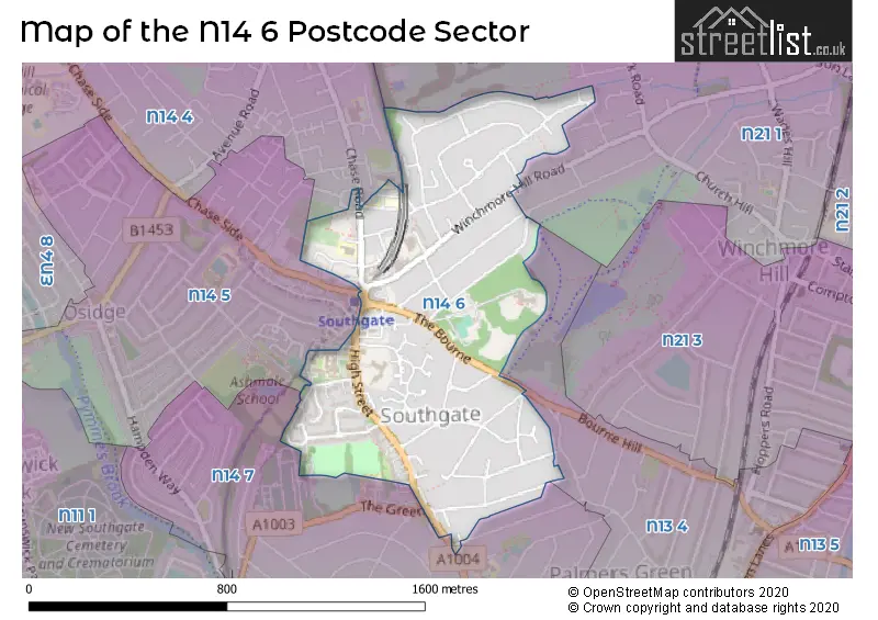
The N14 6 postcode sector is within the county of Greater London.
Did you know? According to the 2021 Census, the N14 6 postcode sector is home to a bustling 7,455 residents!
Given that each sector allows for 400 unique postcode combinations. Letters C, I, K, M, O and V are not allowed in the last two letters of a postcode. With 159 postcodes already in use, this leaves 241 units available.
The largest settlements in the N14 6 postal code are SOUTHGATE and NEW SOUTHGATE .
The N14 6 Postcode shares a border with N14 5 (SOUTHGATE , NEW SOUTHGATE ), N14 7 (SOUTHGATE , WINCHMORE HILL , NEW SOUTHGATE ), N21 1 (SOUTHGATE , WINCHMORE HILL ), N13 4 (SOUTHGATE ) and N14 4 (SOUTHGATE , NEW SOUTHGATE ).
The sector is within the post town of LONDON.
N14 6 is a postcode sector within the N14 postcode district which is within the N North London postcode area.
The Royal Mail delivery office for the N14 6 postal sector is the Southgate Sdelivery Office.
The area of the N14 6 postcode sector is 0.51 square miles which is 1.33 square kilometres or 327.45 square acres.

Map of the N14 6 Postcode Sector
Explore the N14 6 postcode sector by using our free interactive map.
| N | 1 | 4 | - | 6 | X | X |
| N | 1 | 4 | Space | 6 | Letter | Letter |
Official List of Streets
Enfield (48 Streets)
Unofficial Streets or Alternative Spellings
Weather Forecast for N14 6
Press Button to Show Forecast for Wood Green
| Time Period | Icon | Description | Temperature | Rain Probability | Wind |
|---|---|---|---|---|---|
| 21:00 to 00:00 | Cloudy | 15.0°C (feels like 14.0°C) | 4.00% | N 7 mph |
Press Button to Show Forecast for Wood Green
| Time Period | Icon | Description | Temperature | Rain Probability | Wind |
|---|---|---|---|---|---|
| 00:00 to 03:00 | Cloudy | 12.0°C (feels like 11.0°C) | 12.00% | N 9 mph | |
| 03:00 to 06:00 | Heavy rain | 11.0°C (feels like 9.0°C) | 74.00% | NNE 9 mph | |
| 06:00 to 09:00 | Light rain | 11.0°C (feels like 10.0°C) | 48.00% | N 7 mph | |
| 09:00 to 12:00 | Overcast | 14.0°C (feels like 13.0°C) | 11.00% | NNE 4 mph | |
| 12:00 to 15:00 | Cloudy | 17.0°C (feels like 17.0°C) | 5.00% | W 4 mph | |
| 15:00 to 18:00 | Cloudy | 18.0°C (feels like 17.0°C) | 6.00% | WSW 9 mph | |
| 18:00 to 21:00 | Cloudy | 17.0°C (feels like 15.0°C) | 12.00% | W 9 mph | |
| 21:00 to 00:00 | Overcast | 13.0°C (feels like 11.0°C) | 11.00% | W 11 mph |
Press Button to Show Forecast for Wood Green
| Time Period | Icon | Description | Temperature | Rain Probability | Wind |
|---|---|---|---|---|---|
| 00:00 to 03:00 | Overcast | 11.0°C (feels like 9.0°C) | 14.00% | W 11 mph | |
| 03:00 to 06:00 | Overcast | 11.0°C (feels like 8.0°C) | 44.00% | W 11 mph | |
| 06:00 to 09:00 | Light rain | 10.0°C (feels like 8.0°C) | 46.00% | WSW 11 mph | |
| 09:00 to 12:00 | Overcast | 11.0°C (feels like 8.0°C) | 46.00% | WSW 13 mph | |
| 12:00 to 15:00 | Light rain | 13.0°C (feels like 10.0°C) | 47.00% | WSW 13 mph | |
| 15:00 to 18:00 | Light rain | 14.0°C (feels like 11.0°C) | 43.00% | WSW 13 mph | |
| 18:00 to 21:00 | Cloudy | 14.0°C (feels like 12.0°C) | 11.00% | WSW 9 mph | |
| 21:00 to 00:00 | Partly cloudy (night) | 11.0°C (feels like 10.0°C) | 4.00% | SW 7 mph |
Press Button to Show Forecast for Wood Green
| Time Period | Icon | Description | Temperature | Rain Probability | Wind |
|---|---|---|---|---|---|
| 00:00 to 03:00 | Clear night | 10.0°C (feels like 8.0°C) | 2.00% | SW 7 mph | |
| 03:00 to 06:00 | Clear night | 8.0°C (feels like 7.0°C) | 1.00% | SW 4 mph | |
| 06:00 to 09:00 | Sunny day | 9.0°C (feels like 8.0°C) | 3.00% | SSW 4 mph | |
| 09:00 to 12:00 | Partly cloudy (day) | 13.0°C (feels like 12.0°C) | 6.00% | SSW 7 mph | |
| 12:00 to 15:00 | Cloudy | 16.0°C (feels like 14.0°C) | 12.00% | S 9 mph | |
| 15:00 to 18:00 | Cloudy | 17.0°C (feels like 15.0°C) | 13.00% | S 7 mph | |
| 18:00 to 21:00 | Cloudy | 15.0°C (feels like 14.0°C) | 14.00% | SSE 7 mph | |
| 21:00 to 00:00 | Clear night | 12.0°C (feels like 11.0°C) | 10.00% | SSE 7 mph |
Press Button to Show Forecast for Wood Green
| Time Period | Icon | Description | Temperature | Rain Probability | Wind |
|---|---|---|---|---|---|
| 00:00 to 03:00 | Partly cloudy (night) | 10.0°C (feels like 9.0°C) | 11.00% | SSE 4 mph | |
| 03:00 to 06:00 | Overcast | 9.0°C (feels like 8.0°C) | 11.00% | SSE 4 mph | |
| 06:00 to 09:00 | Cloudy | 10.0°C (feels like 9.0°C) | 11.00% | SE 4 mph | |
| 09:00 to 12:00 | Cloudy | 13.0°C (feels like 12.0°C) | 11.00% | SE 7 mph | |
| 12:00 to 15:00 | Cloudy | 16.0°C (feels like 14.0°C) | 13.00% | SE 7 mph | |
| 15:00 to 18:00 | Light rain shower (day) | 15.0°C (feels like 14.0°C) | 36.00% | S 7 mph | |
| 18:00 to 21:00 | Cloudy | 15.0°C (feels like 14.0°C) | 10.00% | S 4 mph | |
| 21:00 to 00:00 | Cloudy | 13.0°C (feels like 12.0°C) | 9.00% | S 4 mph |
Schools and Places of Education Within the N14 6 Postcode Sector
St Andrew's Southgate Primary School (CE)
Voluntary aided school
297 Chase Road, London, , N14 6JA
Head: Mrs Stamatia Pitsillides
Ofsted Rating: Good
Inspection: 2019-09-26 (1679 days ago)
Website: Visit St Andrew's Southgate Primary School (CE) Website
Phone: 02088863379
Number of Pupils: 197
House Prices in the N14 6 Postcode Sector
| Type of Property | 2018 Average | 2018 Sales | 2017 Average | 2017 Sales | 2016 Average | 2016 Sales | 2015 Average | 2015 Sales |
|---|---|---|---|---|---|---|---|---|
| Detached | £671,667 | 3 | £1,207,225 | 6 | £1,072,786 | 14 | £892,200 | 5 |
| Semi-Detached | £774,344 | 24 | £779,162 | 17 | £821,630 | 23 | £705,033 | 30 |
| Terraced | £570,000 | 3 | £677,079 | 7 | £624,750 | 4 | £528,286 | 7 |
| Flats | £403,013 | 22 | £386,658 | 19 | £359,693 | 23 | £331,419 | 31 |
Important Postcodes N14 6 in the Postcode Sector
N14 6AD is the postcode for Southgate Leisure Centre, Winchmore Hill Road
N14 6BN is the postcode for THE MEWS, Durants School, High Street, Durants School, High Street, DINING BLOCK, Durants School, High Street, and London Fire Brigade, Fire Station, 96 High Street
N14 6BP is the postcode for Southgate Circus Library, High Street
N14 6BS is the postcode for ADMISSIONS/LRC, Barnet and Southgate College, High Street, LLDD CENTRE, Barnet and Southgate College, High Street, B BLOCK, Barnet and Southgate College, High Street, FARBY BUILDING/SOUTHGATE HOUSE, Barnet and Southgate College, High Street, SIXTH FORM COLLEGE, Barnet and Southgate College, High Street, and MAIN SITE, Barnet and Southgate College, High Street
N14 6BW is the postcode for Royal Mail, Southgate Delivery Office, 139 High Street
N14 6JA is the postcode for St. Andrews Primary School Southagte, 297 Chase Road
N14 6LZ is the postcode for Chase House, 305 Chase Road
N14 6PW is the postcode for The Grange, 100 High Street
| The N14 6 Sector is within these Local Authorities |
|
|---|---|
| The N14 6 Sector is within these Counties |
|
| The N14 6 Sector is within these Water Company Areas |
|