The N21 2 postcode sector is within the county of Greater London.
Did you know? According to the 2021 Census, the N21 2 postcode sector is home to a bustling 7,661 residents!
Given that each sector allows for 400 unique postcode combinations. Letters C, I, K, M, O and V are not allowed in the last two letters of a postcode. With 169 postcodes already in use, this leaves 231 units available.
The largest settlements in the N21 2 postal code are SOUTHGATE and WINCHMORE HILL .
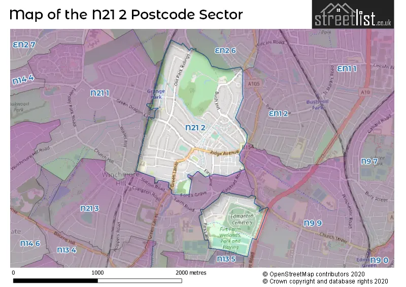
The N21 2 Postcode shares a border with N21 1 (SOUTHGATE , WINCHMORE HILL ), N21 3 (SOUTHGATE , WINCHMORE HILL ), N9 9 (EDMONTON ), N13 5 (SOUTHGATE , PALMERS GREEN ), EN1 2 (ENFIELD ), EN2 6 (ENFIELD ) and EN2 7 (ENFIELD , ENFIELD NORTH ).
The sector is within the post town of LONDON.
N21 2 is a postcode sector within the N21 postcode district which is within the N North London postcode area.
The Royal Mail delivery office for the N21 2 postal sector is the Winchmore Hill Sdelivery Office.
The area of the N21 2 postcode sector is 0.78 square miles which is 2.03 square kilometres or 501.09 square acres.
Waterways within the N21 2 postcode sector include the Salmons Brook, New River.


Map of the N21 2 Postcode Sector
Explore the N21 2 postcode sector by using our free interactive map.
| N | 2 | 1 | - | 2 | X | X |
| N | 2 | 1 | Space | 2 | Letter | Letter |
Official List of Streets
Enfield (55 Streets)
Unofficial Streets or Alternative Spellings
Weather Forecast for N21 2
Press Button to Show Forecast for Enfield
| Time Period | Icon | Description | Temperature | Rain Probability | Wind |
|---|---|---|---|---|---|
| 15:00 to 18:00 | Overcast | 11.0°C (feels like 9.0°C) | 47.00% | NE 9 mph | |
| 18:00 to 21:00 | Heavy rain | 10.0°C (feels like 8.0°C) | 85.00% | NE 11 mph | |
| 21:00 to 00:00 | Heavy rain | 9.0°C (feels like 6.0°C) | 91.00% | NE 11 mph |
Press Button to Show Forecast for Enfield
| Time Period | Icon | Description | Temperature | Rain Probability | Wind |
|---|---|---|---|---|---|
| 00:00 to 03:00 | Heavy rain | 8.0°C (feels like 6.0°C) | 92.00% | NNE 9 mph | |
| 03:00 to 06:00 | Heavy rain | 9.0°C (feels like 8.0°C) | 93.00% | E 7 mph | |
| 06:00 to 09:00 | Cloudy | 9.0°C (feels like 8.0°C) | 44.00% | SW 7 mph | |
| 09:00 to 12:00 | Heavy rain | 10.0°C (feels like 8.0°C) | 79.00% | WSW 9 mph | |
| 12:00 to 15:00 | Light rain | 8.0°C (feels like 5.0°C) | 58.00% | W 13 mph | |
| 15:00 to 18:00 | Cloudy | 9.0°C (feels like 6.0°C) | 49.00% | WSW 11 mph | |
| 18:00 to 21:00 | Cloudy | 10.0°C (feels like 8.0°C) | 7.00% | SW 9 mph | |
| 21:00 to 00:00 | Clear night | 9.0°C (feels like 7.0°C) | 1.00% | SW 7 mph |
Press Button to Show Forecast for Enfield
| Time Period | Icon | Description | Temperature | Rain Probability | Wind |
|---|---|---|---|---|---|
| 00:00 to 03:00 | Clear night | 8.0°C (feels like 6.0°C) | 1.00% | SW 7 mph | |
| 03:00 to 06:00 | Clear night | 6.0°C (feels like 5.0°C) | 0.00% | SSW 4 mph | |
| 06:00 to 09:00 | Sunny day | 7.0°C (feels like 5.0°C) | 0.00% | S 7 mph | |
| 09:00 to 12:00 | Partly cloudy (day) | 12.0°C (feels like 10.0°C) | 1.00% | SSW 11 mph | |
| 12:00 to 15:00 | Partly cloudy (day) | 14.0°C (feels like 12.0°C) | 2.00% | S 11 mph | |
| 15:00 to 18:00 | Partly cloudy (day) | 15.0°C (feels like 12.0°C) | 1.00% | S 13 mph | |
| 18:00 to 21:00 | Sunny day | 14.0°C (feels like 12.0°C) | 2.00% | S 11 mph | |
| 21:00 to 00:00 | Clear night | 11.0°C (feels like 10.0°C) | 1.00% | SSE 7 mph |
Press Button to Show Forecast for Enfield
| Time Period | Icon | Description | Temperature | Rain Probability | Wind |
|---|---|---|---|---|---|
| 00:00 to 03:00 | Clear night | 10.0°C (feels like 8.0°C) | 1.00% | SE 7 mph | |
| 03:00 to 06:00 | Clear night | 9.0°C (feels like 7.0°C) | 1.00% | ESE 7 mph | |
| 06:00 to 09:00 | Partly cloudy (day) | 10.0°C (feels like 8.0°C) | 1.00% | ESE 7 mph | |
| 09:00 to 12:00 | Cloudy | 13.0°C (feels like 12.0°C) | 8.00% | SE 7 mph | |
| 12:00 to 15:00 | Light rain shower (day) | 16.0°C (feels like 14.0°C) | 31.00% | SE 9 mph | |
| 15:00 to 18:00 | Light rain shower (day) | 16.0°C (feels like 15.0°C) | 31.00% | SE 9 mph | |
| 18:00 to 21:00 | Cloudy | 16.0°C (feels like 14.0°C) | 12.00% | SE 7 mph | |
| 21:00 to 00:00 | Cloudy | 13.0°C (feels like 12.0°C) | 12.00% | ESE 7 mph |
Press Button to Show Forecast for Enfield
| Time Period | Icon | Description | Temperature | Rain Probability | Wind |
|---|---|---|---|---|---|
| 00:00 to 03:00 | Cloudy | 12.0°C (feels like 11.0°C) | 15.00% | ESE 4 mph | |
| 03:00 to 06:00 | Cloudy | 11.0°C (feels like 11.0°C) | 11.00% | ESE 4 mph | |
| 06:00 to 09:00 | Fog | 11.0°C (feels like 11.0°C) | 19.00% | E 4 mph | |
| 09:00 to 12:00 | Cloudy | 14.0°C (feels like 14.0°C) | 13.00% | E 4 mph | |
| 12:00 to 15:00 | Partly cloudy (day) | 17.0°C (feels like 17.0°C) | 12.00% | E 4 mph | |
| 15:00 to 18:00 | Cloudy | 19.0°C (feels like 18.0°C) | 15.00% | ESE 7 mph | |
| 18:00 to 21:00 | Cloudy | 17.0°C (feels like 16.0°C) | 11.00% | SE 7 mph | |
| 21:00 to 00:00 | Cloudy | 14.0°C (feels like 13.0°C) | 11.00% | N 7 mph |
Schools and Places of Education Within the N21 2 Postcode Sector
St Paul's CofE Primary School
Voluntary aided school
Ringwood Way, London, , N21 2RA
Head: Miss Cathyrn Mann
Ofsted Rating: Good
Inspection: 2023-12-14 (135 days ago)
Website: Visit St Paul's CofE Primary School Website
Phone: 02083603137
Number of Pupils: 415
House Prices in the N21 2 Postcode Sector
| Type of Property | 2018 Average | 2018 Sales | 2017 Average | 2017 Sales | 2016 Average | 2016 Sales | 2015 Average | 2015 Sales |
|---|---|---|---|---|---|---|---|---|
| Detached | £1,005,375 | 8 | £1,026,607 | 14 | £1,262,385 | 13 | £1,122,500 | 10 |
| Semi-Detached | £838,500 | 17 | £764,780 | 25 | £760,747 | 25 | £687,403 | 28 |
| Terraced | £651,432 | 22 | £589,602 | 28 | £599,711 | 19 | £503,800 | 20 |
| Flats | £348,770 | 20 | £354,163 | 21 | £322,284 | 35 | £309,303 | 40 |
Important Postcodes N21 2 in the Postcode Sector
N21 2RA is the postcode for St. Pauls C of E Primary School, Ringwood Way, and MAIN BUILDING, St. Pauls C of E Primary School, Ringwood Way
N21 2RH is the postcode for London Borough of Enfield, Ridge Avenue Library, Ridge Avenue
N21 2ST is the postcode for H M Revenue & Customs, Capitol House, 794 Green Lanes
| The N21 2 Sector is within these Local Authorities |
|
|---|---|
| The N21 2 Sector is within these Counties |
|
| The N21 2 Sector is within these Water Company Areas |
|