The N22 6 postcode sector is within the county of Greater London.
Did you know? According to the 2021 Census, the N22 6 postcode sector is home to a bustling 13,085 residents!
Given that each sector allows for 400 unique postcode combinations. Letters C, I, K, M, O and V are not allowed in the last two letters of a postcode. With 198 postcodes already in use, this leaves 202 units available.
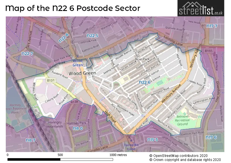
The largest settlements in the N22 6 postal code are WOOD GREEN and TOTTENHAM .
The N22 6 Postcode shares a border with N8 0 (HORNSEY , WOOD GREEN , TOTTENHAM ), N8 7 (HORNSEY ), N22 5 (WOOD GREEN ), N22 7 (WOOD GREEN , HORNSEY ), N22 8 (WOOD GREEN , SOUTHGATE ), N15 3 (TOTTENHAM ) and N17 6 (TOTTENHAM ).
The sector is within the post town of LONDON.
N22 6 is a postcode sector within the N22 postcode district which is within the N North London postcode area.
The Royal Mail delivery office for the N22 6 postal sector is the Wood Green Sdelivery Office.
The area of the N22 6 postcode sector is 0.42 square miles which is 1.09 square kilometres or 269.10 square acres.

Map of the N22 6 Postcode Sector
Explore the N22 6 postcode sector by using our free interactive map.
| N | 2 | 2 | - | 6 | X | X |
| N | 2 | 2 | Space | 6 | Letter | Letter |
Official List of Streets
Haringey (54 Streets)
Unofficial Streets or Alternative Spellings
Haringey
ALEXANDRA ROAD BULLER ROAD COLERAINE ROAD COURCY ROAD CUMBERLAND ROAD DOWNHILLS PARK ROAD IVATT WAY LANGHAM ROAD LORDSHIP LANE MARY NEUNER ROAD RIVER PARK ROAD AMBER MEWS BARBARA HUCKLESBURY CLOSE BITTERN PLACE DOVECOTE AVENUE MARTINS WALK MICHAEL THOMPSON PASSAGE PENSTOCK PATH PENSTOCK TUNNEL RUSSELL GATE SILSOE ROAD VINCENT SQUAREWeather Forecast for N22 6
Press Button to Show Forecast for Wood Green
| Time Period | Icon | Description | Temperature | Rain Probability | Wind |
|---|---|---|---|---|---|
| 03:00 to 06:00 | Heavy rain | 7.0°C (feels like 5.0°C) | 85.00% | NE 7 mph | |
| 06:00 to 09:00 | Heavy rain | 6.0°C (feels like 4.0°C) | 87.00% | NE 7 mph | |
| 09:00 to 12:00 | Overcast | 8.0°C (feels like 5.0°C) | 41.00% | NE 9 mph | |
| 12:00 to 15:00 | Overcast | 11.0°C (feels like 9.0°C) | 13.00% | ENE 9 mph | |
| 15:00 to 18:00 | Cloudy | 12.0°C (feels like 11.0°C) | 17.00% | NE 7 mph | |
| 18:00 to 21:00 | Light rain | 11.0°C (feels like 9.0°C) | 61.00% | NE 9 mph | |
| 21:00 to 00:00 | Heavy rain | 10.0°C (feels like 7.0°C) | 89.00% | NE 9 mph |
Press Button to Show Forecast for Wood Green
| Time Period | Icon | Description | Temperature | Rain Probability | Wind |
|---|---|---|---|---|---|
| 00:00 to 03:00 | Heavy rain | 9.0°C (feels like 6.0°C) | 92.00% | NNE 11 mph | |
| 03:00 to 06:00 | Heavy rain | 9.0°C (feels like 7.0°C) | 92.00% | NE 9 mph | |
| 06:00 to 09:00 | Heavy rain | 9.0°C (feels like 7.0°C) | 86.00% | NNW 7 mph | |
| 09:00 to 12:00 | Heavy rain | 9.0°C (feels like 7.0°C) | 83.00% | WNW 9 mph | |
| 12:00 to 15:00 | Light rain | 9.0°C (feels like 7.0°C) | 56.00% | W 13 mph | |
| 15:00 to 18:00 | Overcast | 10.0°C (feels like 8.0°C) | 16.00% | W 11 mph | |
| 18:00 to 21:00 | Cloudy | 11.0°C (feels like 9.0°C) | 8.00% | W 9 mph | |
| 21:00 to 00:00 | Partly cloudy (night) | 9.0°C (feels like 8.0°C) | 4.00% | SW 7 mph |
Press Button to Show Forecast for Wood Green
| Time Period | Icon | Description | Temperature | Rain Probability | Wind |
|---|---|---|---|---|---|
| 00:00 to 03:00 | Clear night | 8.0°C (feels like 7.0°C) | 2.00% | SW 4 mph | |
| 03:00 to 06:00 | Clear night | 7.0°C (feels like 5.0°C) | 1.00% | SSW 4 mph | |
| 06:00 to 09:00 | Sunny day | 7.0°C (feels like 6.0°C) | 1.00% | S 4 mph | |
| 09:00 to 12:00 | Partly cloudy (day) | 12.0°C (feels like 10.0°C) | 1.00% | SSW 9 mph | |
| 12:00 to 15:00 | Cloudy | 14.0°C (feels like 12.0°C) | 6.00% | S 9 mph | |
| 15:00 to 18:00 | Partly cloudy (day) | 15.0°C (feels like 13.0°C) | 2.00% | S 11 mph | |
| 18:00 to 21:00 | Sunny day | 14.0°C (feels like 12.0°C) | 3.00% | S 9 mph | |
| 21:00 to 00:00 | Clear night | 11.0°C (feels like 10.0°C) | 1.00% | SSE 7 mph |
Press Button to Show Forecast for Wood Green
| Time Period | Icon | Description | Temperature | Rain Probability | Wind |
|---|---|---|---|---|---|
| 00:00 to 03:00 | Clear night | 10.0°C (feels like 8.0°C) | 1.00% | SE 7 mph | |
| 03:00 to 06:00 | Clear night | 9.0°C (feels like 7.0°C) | 2.00% | ESE 7 mph | |
| 06:00 to 09:00 | Cloudy | 9.0°C (feels like 8.0°C) | 7.00% | ESE 7 mph | |
| 09:00 to 12:00 | Cloudy | 13.0°C (feels like 12.0°C) | 6.00% | ESE 7 mph | |
| 12:00 to 15:00 | Cloudy | 16.0°C (feels like 14.0°C) | 8.00% | SE 9 mph | |
| 15:00 to 18:00 | Cloudy | 17.0°C (feels like 15.0°C) | 10.00% | SE 9 mph | |
| 18:00 to 21:00 | Cloudy | 16.0°C (feels like 14.0°C) | 11.00% | SE 9 mph | |
| 21:00 to 00:00 | Cloudy | 13.0°C (feels like 12.0°C) | 15.00% | ESE 7 mph |
Schools and Places of Education Within the N22 6 Postcode Sector
Alexandra Primary School
Community school
Western Road, London, , N22 6UH
Head: Mrs Stephanie Clarke
Ofsted Rating: Good
Inspection: 2022-03-16 (773 days ago)
Website: Visit Alexandra Primary School Website
Phone: 02088889771
Number of Pupils: 403
Area 51 Education Ltd
Special post 16 institution
1 Mallard Place, London, , N22 6TS
Head: Nicki Quarterman
Ofsted Rating: Requires improvement
Inspection: 2022-09-23 (582 days ago)
Website: Visit Area 51 Education Ltd Website
Phone: 02088817739
Number of Pupils: 0
Belmont Infant School
Community school
Rusper Road, London, , N22 6RA
Head: Ms Fiona Crean
Ofsted Rating: Good
Inspection: 2023-03-09 (415 days ago)
Website: Visit Belmont Infant School Website
Phone: 02088887140
Number of Pupils: 212
Belmont Junior School
Community school
Rusper Road, London, , N22 6RA
Head: Ms Claire Piggott
Ofsted Rating: Good
Inspection: 2022-04-21 (737 days ago)
Website: Visit Belmont Junior School Website
Phone: 02088888261
Number of Pupils: 222
Noel Park Primary School
Academy sponsor led
Gladstone Avenue, London, , N22 6LH
Head: Ms Tamsin Brown
Ofsted Rating: Outstanding
Inspection: 2019-03-20 (1865 days ago)
Website: Visit Noel Park Primary School Website
Phone: 02088888967
Number of Pupils: 587
House Prices in the N22 6 Postcode Sector
| Type of Property | 2018 Average | 2018 Sales | 2017 Average | 2017 Sales | 2016 Average | 2016 Sales | 2015 Average | 2015 Sales |
|---|---|---|---|---|---|---|---|---|
| Detached | £0 | 0 | £0 | 0 | £0 | 0 | £1,025,000 | 1 |
| Semi-Detached | £472,500 | 2 | £0 | 0 | £581,000 | 2 | £480,000 | 1 |
| Terraced | £521,724 | 43 | £546,956 | 44 | £523,823 | 66 | £474,891 | 63 |
| Flats | £366,889 | 29 | £374,448 | 30 | £370,514 | 47 | £281,545 | 41 |
Important Postcodes N22 6 in the Postcode Sector
N22 6BA is the postcode for Wood Green Library Shopping Arcade, 187-197 High Road
N22 6HE is the postcode for Unit 7, 88-96 High Road, and MPS FIRST FLOOR, Unit 7, 88-96 High Road
N22 6LH is the postcode for Noel Park Primary School, Gladstone Avenue
N22 6RA is the postcode for Belmont Infants School, Rusper Road, Belmont Junior & Infant School, Rusper Road, and Belmont Junior School, Rusper Road
N22 6UG is the postcode for Haringey Council, 95 Western Road
N22 6UH is the postcode for BLOCK B & NURSERY, Alexandra Junior & Infant School, Western Road, Alexandra Junior & Infant School, Western Road, and BLOCK A, Alexandra Junior & Infant School, Western Road
N22 6UR is the postcode for Cambridge House, 109 Mayes Road
N22 6UU is the postcode for Granta House, 1 Western Road, and Jobcentre Plus, Granta House, 1 Western Road
N22 6UW is the postcode for 13-27 Station Road
N22 6UX is the postcode for 36-46 Station Road
N22 6XD is the postcode for Haringey Council, Wood Green Central Library, High Road, and Wood Green Library, 187-197A High Road
| The N22 6 Sector is within these Local Authorities |
|
|---|---|
| The N22 6 Sector is within these Counties |
|
| The N22 6 Sector is within these Water Company Areas |
|