The N5 postcode district is a postal district located in the N London - N postcode area with a population of 25,724 residents according to the 2021 England and Wales Census.
The area of the N5 postcode district is 0.70 square miles which is 1.81 square kilometres or 448.42 acres.
Currently, the N5 district has about 418 postcode units spread across 2 geographic postcode sectors.
Given that each sector allows for 400 unique postcode combinations, the district has a capacity of 800 postcodes. With 418 postcodes already in use, this leaves 382 units available.
The N5 postal code covers the settlement of ISLINGTON.
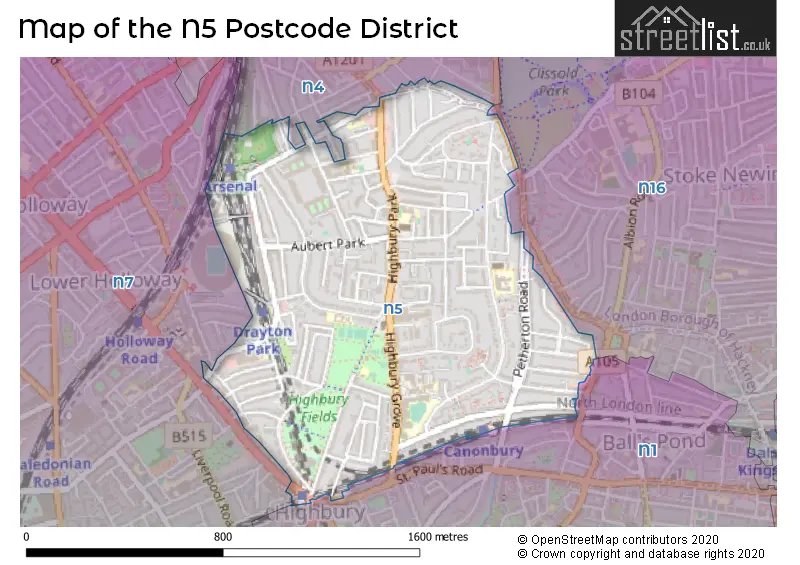
The N5 Postcode shares a border with N16 (HACKNEY), N4 (HACKNEY, HORNSEY, ISLINGTON), N7 (ISLINGTON) and N1 (ISLINGTON, HACKNEY).
In the N5 postcode district, the primary settlement is Islington, located in the post town of London, in the Greater London county. Hackney is another significant settlement within the same postcode district.
For the district N5, we have data on 3 postcode sectors. Here's a breakdown: The sector N5 1, covers Islington in Greater London. The sector N5 2, covers Islington in Greater London. The sector N5 9 is non-geographic. It's often designated for PO Boxes, large organisations, or special services.

Map of the N5 Postcode District
Explore the N5 postcode district by using our free interactive map.
When it comes to local government, postal geography often disregards political borders. However, for a breakdown in the N5 District: the district mostly encompasses the Islington London Boro (411 postcodes), and finally, the Hackney London Boro area (6 postcodes).
Recent House Sales in N5
| Date | Price | Address |
|---|---|---|
| 16/10/2023 | £840,000 | Poets Road, London, N5 2SH |
| 13/10/2023 | £440,000 | Highbury Grove, London, N5 2AG |
| 11/09/2023 | £451,000 | Mountgrove Road, London, N5 2LT |
| 04/09/2023 | £545,000 | Highbury Stadium Square, London, N5 1FE |
| 04/09/2023 | £500,000 | Highbury Estate, London, N5 2NU |
| 04/09/2023 | £570,000 | Melgund Road, London, N5 1PT |
| 01/09/2023 | £675,000 | Highbury Stadium Square, London, N5 1FD |
| 31/08/2023 | £1,310,000 | Leigh Road, London, N5 1ST |
| 30/08/2023 | £625,000 | Highbury Hill, London, N5 1AL |
| 28/08/2023 | £750,000 | Highbury Stadium Square, London, N5 1FJ |
Weather Forecast for N5
Press Button to Show Forecast for Arsenal F.C.
| Time Period | Icon | Description | Temperature | Rain Probability | Wind |
|---|---|---|---|---|---|
| 15:00 to 18:00 | Cloudy | 11.0°C (feels like 10.0°C) | 9.00% | NE 9 mph | |
| 18:00 to 21:00 | Heavy rain | 10.0°C (feels like 8.0°C) | 88.00% | NE 9 mph | |
| 21:00 to 00:00 | Heavy rain | 9.0°C (feels like 6.0°C) | 91.00% | NE 11 mph |
Press Button to Show Forecast for Arsenal F.C.
| Time Period | Icon | Description | Temperature | Rain Probability | Wind |
|---|---|---|---|---|---|
| 00:00 to 03:00 | Heavy rain | 9.0°C (feels like 7.0°C) | 91.00% | NNE 9 mph | |
| 03:00 to 06:00 | Heavy rain | 10.0°C (feels like 8.0°C) | 91.00% | E 7 mph | |
| 06:00 to 09:00 | Cloudy | 10.0°C (feels like 8.0°C) | 51.00% | SW 7 mph | |
| 09:00 to 12:00 | Light rain | 10.0°C (feels like 8.0°C) | 62.00% | WSW 9 mph | |
| 12:00 to 15:00 | Light rain | 8.0°C (feels like 5.0°C) | 58.00% | W 13 mph | |
| 15:00 to 18:00 | Cloudy | 9.0°C (feels like 6.0°C) | 21.00% | WSW 11 mph | |
| 18:00 to 21:00 | Cloudy | 11.0°C (feels like 9.0°C) | 6.00% | SW 9 mph | |
| 21:00 to 00:00 | Clear night | 9.0°C (feels like 7.0°C) | 1.00% | SW 7 mph |
Press Button to Show Forecast for Arsenal F.C.
| Time Period | Icon | Description | Temperature | Rain Probability | Wind |
|---|---|---|---|---|---|
| 00:00 to 03:00 | Clear night | 8.0°C (feels like 6.0°C) | 0.00% | SSW 7 mph | |
| 03:00 to 06:00 | Clear night | 7.0°C (feels like 5.0°C) | 0.00% | SSW 7 mph | |
| 06:00 to 09:00 | Sunny day | 8.0°C (feels like 6.0°C) | 0.00% | S 7 mph | |
| 09:00 to 12:00 | Partly cloudy (day) | 12.0°C (feels like 10.0°C) | 2.00% | S 9 mph | |
| 12:00 to 15:00 | Partly cloudy (day) | 15.0°C (feels like 12.0°C) | 3.00% | S 11 mph | |
| 15:00 to 18:00 | Partly cloudy (day) | 15.0°C (feels like 12.0°C) | 3.00% | S 13 mph | |
| 18:00 to 21:00 | Sunny day | 14.0°C (feels like 12.0°C) | 3.00% | S 9 mph | |
| 21:00 to 00:00 | Clear night | 11.0°C (feels like 10.0°C) | 1.00% | SSE 7 mph |
Press Button to Show Forecast for Arsenal F.C.
| Time Period | Icon | Description | Temperature | Rain Probability | Wind |
|---|---|---|---|---|---|
| 00:00 to 03:00 | Clear night | 10.0°C (feels like 8.0°C) | 1.00% | SE 7 mph | |
| 03:00 to 06:00 | Clear night | 9.0°C (feels like 8.0°C) | 1.00% | ESE 4 mph | |
| 06:00 to 09:00 | Partly cloudy (day) | 10.0°C (feels like 8.0°C) | 1.00% | ESE 7 mph | |
| 09:00 to 12:00 | Partly cloudy (day) | 14.0°C (feels like 13.0°C) | 6.00% | SE 7 mph | |
| 12:00 to 15:00 | Light rain shower (day) | 16.0°C (feels like 14.0°C) | 33.00% | SE 9 mph | |
| 15:00 to 18:00 | Light rain shower (day) | 17.0°C (feels like 15.0°C) | 31.00% | SE 9 mph | |
| 18:00 to 21:00 | Light rain shower (day) | 16.0°C (feels like 15.0°C) | 33.00% | SE 7 mph | |
| 21:00 to 00:00 | Partly cloudy (night) | 14.0°C (feels like 13.0°C) | 11.00% | ESE 4 mph |
Press Button to Show Forecast for Arsenal F.C.
| Time Period | Icon | Description | Temperature | Rain Probability | Wind |
|---|---|---|---|---|---|
| 00:00 to 03:00 | Cloudy | 12.0°C (feels like 12.0°C) | 15.00% | ESE 4 mph | |
| 03:00 to 06:00 | Overcast | 11.0°C (feels like 11.0°C) | 13.00% | ESE 4 mph | |
| 06:00 to 09:00 | Fog | 11.0°C (feels like 11.0°C) | 19.00% | ESE 4 mph | |
| 09:00 to 12:00 | Cloudy | 14.0°C (feels like 13.0°C) | 15.00% | ENE 4 mph | |
| 12:00 to 15:00 | Partly cloudy (day) | 17.0°C (feels like 16.0°C) | 11.00% | E 4 mph | |
| 15:00 to 18:00 | Cloudy | 19.0°C (feels like 18.0°C) | 14.00% | ENE 7 mph | |
| 18:00 to 21:00 | Cloudy | 18.0°C (feels like 17.0°C) | 11.00% | SSE 7 mph | |
| 21:00 to 00:00 | Cloudy | 15.0°C (feels like 14.0°C) | 11.00% | S 7 mph |
Where is the N5 Postcode District?
The postcode district N5 is located in London. It is specifically in the district town of Islington, which is situated southwest of the centre of London. Additionally, nearby towns include Hackney to the east, Barbican to the south, Hornsey to the northwest, and Tottenham to the north. The distance from N5 to the centre of London is approximately 3.45 miles.
The district is within the post town of LONDON.
The sector has postcodes within the nation of England.
The N5 Postcode District is covers the following regions.
- Haringey and Islington - Inner London - East - London
- Hackney and Newham - Inner London - East - London
| Postcode Sector | Delivery Office |
|---|---|
| N5 1 | Highbury Sdelivery Office |
| N5 2 | Highbury Sdelivery Office |
| N | 5 | - | X | X | X |
| N | 5 | Space | Numeric | Letter | Letter |
Current Monthly Rental Prices
| # Bedrooms | Min Price | Max Price | Avg Price |
|---|---|---|---|
| £100 | £3,033 | £1,382 | |
| 1 | £1,699 | £2,700 | £2,087 |
| 2 | £2,253 | £5,200 | £2,977 |
| 3 | £3,000 | £8,212 | £4,297 |
| 4 | £2,999 | £6,000 | £4,212 |
Current House Prices
| # Bedrooms | Min Price | Max Price | Avg Price |
|---|---|---|---|
| £280,000 | £3,500,000 | £1,396,000 | |
| 1 | £150,000 | £800,000 | £466,354 |
| 2 | £375,000 | £1,500,000 | £690,656 |
| 3 | £525,000 | £1,650,000 | £989,550 |
| 4 | £500,000 | £2,850,000 | £1,753,329 |
| 5 | £2,000,000 | £3,500,000 | £2,621,429 |
| 6 | £2,500,000 | £2,800,000 | £2,700,000 |
| 7 | £8,000,000 | £8,000,000 | £8,000,000 |
Estate Agents who Operate in the N5 District
| Logo | Name | Brand Name | Address | Contact Number | Total Properties |
|---|---|---|---|---|---|
 | Islington | Foxtons | 355 Upper Street London N1 0PD | 020 3840 3931 | 24 |
 | Highbury Park | Winkworth | 106 Highbury Park, London, N5 2XE | 020 3889 9071 | 23 |
 | Highbury | Hotblack Desiato | 2 Highbury Park, London, N5 2AB | 020 3866 5533 | 23 |
 | Islington | Hamptons Sales | 97-99 Upper Street London N1 0NP | 020 3835 5298 | 17 |
 | Islington | Dexters | 76 Upper Street London N1 0NU | 020 7483 6374 | 14 |
| Type of Property | 2018 Average | 2018 Sales | 2017 Average | 2017 Sales | 2016 Average | 2016 Sales | 2015 Average | 2015 Sales |
|---|---|---|---|---|---|---|---|---|
| Detached | £2,000,000 | 2 | £1,880,000 | 2 | £2,722,700 | 2 | £3,620,000 | 2 |
| Semi-Detached | £1,281,667 | 3 | £1,900,000 | 2 | £1,355,475 | 2 | £2,630,143 | 7 |
| Terraced | £1,413,265 | 49 | £1,436,925 | 70 | £1,378,515 | 51 | £1,483,932 | 75 |
| Flats | £564,980 | 214 | £579,216 | 223 | £597,437 | 273 | £586,356 | 252 |