The N4 postcode district is a postal district located in the N London - N postcode area with a population of 53,182 residents according to the 2021 England and Wales Census.
The area of the N4 postcode district is 1.63 square miles which is 4.21 square kilometres or 1,041.41 acres.
Currently, the N4 district has about 858 postcode units spread across 4 geographic postcode sectors.
Given that each sector allows for 400 unique postcode combinations, the district has a capacity of 1,600 postcodes. With 858 postcodes already in use, this leaves 742 units available.
The largest settlement in the N4 postal code is HACKNEY followed by HORNSEY, and ISLINGTON.
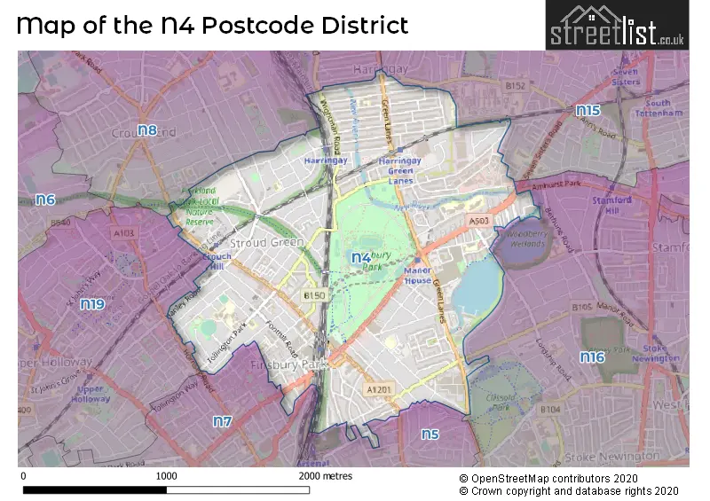
The N4 Postcode shares a border with N15 (TOTTENHAM), N16 (HACKNEY), N19 (ISLINGTON), N5 (ISLINGTON), N7 (ISLINGTON) and N8 (HORNSEY).
The primary settlement in the N4 postcode district is Hackney, located in the county of Greater London, England. Other significant settlements in the district include Haringey and Islington, also in Greater London. The most significant post town in the N4 postcode district is London.
For the district N4, we have data on 5 postcode sectors. Here's a breakdown: The sector N4 1, covers Haringey and Hackney in Greater London. The sector N4 2, covers Hackney and Islington in Greater London. The sector N4 3, covers Islington and Haringey in Greater London. The sector N4 4, covers Haringey and Islington in Greater London. The sector N4 9 is non-geographic. It's often designated for PO Boxes, large organisations, or special services.


Map of the N4 Postcode District
Explore the N4 postcode district by using our free interactive map.
When it comes to local government, postal geography often disregards political borders. However, for a breakdown in the N4 District: the district mostly encompasses the Haringey London Boro (332 postcodes), followed by the Islington London Boro area (277 postcodes), and finally, the Hackney London Boro area (256 postcodes).
Recent House Sales in N4
| Date | Price | Address |
|---|---|---|
| 06/10/2023 | £352,500 | Cavendish Road, London, N4 1RT |
| 27/09/2023 | £718,000 | Blackstock Road, London, N4 2JS |
| 25/09/2023 | £910,000 | Myddleton Avenue, London, N4 2FL |
| 25/09/2023 | £480,000 | Murrain Road, London, N4 2BN |
| 22/09/2023 | £847,000 | Tollington Park, London, N4 3QZ |
| 20/09/2023 | £900,000 | Stapleton Hall Road, London, N4 4QR |
| 19/09/2023 | £435,000 | Pemberton Road, London, N4 1AX |
| 18/09/2023 | £765,000 | Devan Grove, London, N4 2GL |
| 11/09/2023 | £745,000 | Lancaster Road, London, N4 4PR |
| 08/09/2023 | £835,000 | Hermitage Road, London, N4 1NP |
Where is the N4 Postcode District?
The postcode district N4 is located in LONDON. It is approximately 4.5 miles away from the center of London. The nearby towns to N4 district include Hornsey (1.6 miles to the North West), Islington (1.7 miles to the South), Tottenham (1.9 miles to the North East), Wood Green (2.1 miles to the North), Hackney (2.2 miles to the South East), and Camden Town (2.9 miles to the South West).
The district is within the post town of LONDON.
The sector has postcodes within the nation of England.
The N4 Postcode District is covers the following regions.
- Haringey and Islington - Inner London - East - London
- Hackney and Newham - Inner London - East - London
- Enfield - Outer London - East and North East - London
Weather Forecast for N4
Press Button to Show Forecast for Harringay
| Time Period | Icon | Description | Temperature | Rain Probability | Wind |
|---|---|---|---|---|---|
| 06:00 to 09:00 | Overcast | 12.0°C (feels like 11.0°C) | 8.00% | E 7 mph | |
| 09:00 to 12:00 | Cloudy | 16.0°C (feels like 15.0°C) | 3.00% | ENE 7 mph | |
| 12:00 to 15:00 | Partly cloudy (day) | 22.0°C (feels like 20.0°C) | 0.00% | E 11 mph | |
| 15:00 to 18:00 | Partly cloudy (day) | 23.0°C (feels like 20.0°C) | 0.00% | E 11 mph | |
| 18:00 to 21:00 | Sunny day | 20.0°C (feels like 18.0°C) | 0.00% | E 11 mph | |
| 21:00 to 00:00 | Clear night | 16.0°C (feels like 15.0°C) | 0.00% | E 9 mph |
Press Button to Show Forecast for Harringay
| Time Period | Icon | Description | Temperature | Rain Probability | Wind |
|---|---|---|---|---|---|
| 00:00 to 03:00 | Cloudy | 15.0°C (feels like 14.0°C) | 3.00% | ENE 7 mph | |
| 03:00 to 06:00 | Partly cloudy (night) | 15.0°C (feels like 14.0°C) | 1.00% | ENE 7 mph | |
| 06:00 to 09:00 | Cloudy | 15.0°C (feels like 15.0°C) | 4.00% | ENE 7 mph | |
| 09:00 to 12:00 | Partly cloudy (day) | 19.0°C (feels like 18.0°C) | 1.00% | E 7 mph | |
| 12:00 to 15:00 | Partly cloudy (day) | 24.0°C (feels like 22.0°C) | 1.00% | ESE 9 mph | |
| 15:00 to 18:00 | Partly cloudy (day) | 24.0°C (feels like 23.0°C) | 5.00% | ESE 9 mph | |
| 18:00 to 21:00 | Cloudy | 23.0°C (feels like 22.0°C) | 8.00% | SE 7 mph | |
| 21:00 to 00:00 | Cloudy | 19.0°C (feels like 17.0°C) | 8.00% | SSW 7 mph |
Press Button to Show Forecast for Harringay
| Time Period | Icon | Description | Temperature | Rain Probability | Wind |
|---|---|---|---|---|---|
| 00:00 to 03:00 | Cloudy | 16.0°C (feels like 15.0°C) | 16.00% | SSW 7 mph | |
| 03:00 to 06:00 | Partly cloudy (night) | 14.0°C (feels like 13.0°C) | 7.00% | SSW 7 mph | |
| 06:00 to 09:00 | Cloudy | 14.0°C (feels like 13.0°C) | 9.00% | SSW 9 mph | |
| 09:00 to 12:00 | Cloudy | 16.0°C (feels like 14.0°C) | 9.00% | SSW 11 mph | |
| 12:00 to 15:00 | Cloudy | 18.0°C (feels like 15.0°C) | 10.00% | S 13 mph | |
| 15:00 to 18:00 | Cloudy | 18.0°C (feels like 15.0°C) | 18.00% | S 13 mph | |
| 18:00 to 21:00 | Cloudy | 17.0°C (feels like 15.0°C) | 25.00% | SSE 11 mph | |
| 21:00 to 00:00 | Heavy rain | 16.0°C (feels like 14.0°C) | 79.00% | SSE 11 mph |
Press Button to Show Forecast for Harringay
| Time Period | Icon | Description | Temperature | Rain Probability | Wind |
|---|---|---|---|---|---|
| 00:00 to 03:00 | Heavy rain | 15.0°C (feels like 13.0°C) | 77.00% | SSE 9 mph | |
| 03:00 to 06:00 | Heavy rain | 14.0°C (feels like 13.0°C) | 75.00% | SSE 9 mph | |
| 06:00 to 09:00 | Heavy rain | 14.0°C (feels like 13.0°C) | 76.00% | SSE 7 mph | |
| 09:00 to 12:00 | Light rain | 15.0°C (feels like 13.0°C) | 58.00% | S 9 mph | |
| 12:00 to 15:00 | Cloudy | 17.0°C (feels like 14.0°C) | 23.00% | S 13 mph | |
| 15:00 to 18:00 | Cloudy | 18.0°C (feels like 15.0°C) | 18.00% | S 13 mph | |
| 18:00 to 21:00 | Partly cloudy (day) | 17.0°C (feels like 14.0°C) | 8.00% | S 11 mph | |
| 21:00 to 00:00 | Clear night | 14.0°C (feels like 13.0°C) | 7.00% | SSE 9 mph |
Press Button to Show Forecast for Harringay
| Time Period | Icon | Description | Temperature | Rain Probability | Wind |
|---|---|---|---|---|---|
| 00:00 to 03:00 | Partly cloudy (night) | 13.0°C (feels like 12.0°C) | 4.00% | SSE 9 mph | |
| 03:00 to 06:00 | Partly cloudy (night) | 12.0°C (feels like 11.0°C) | 4.00% | S 7 mph | |
| 06:00 to 09:00 | Partly cloudy (day) | 13.0°C (feels like 11.0°C) | 5.00% | S 9 mph | |
| 09:00 to 12:00 | Partly cloudy (day) | 15.0°C (feels like 13.0°C) | 8.00% | S 11 mph | |
| 12:00 to 15:00 | Partly cloudy (day) | 17.0°C (feels like 14.0°C) | 10.00% | S 13 mph | |
| 15:00 to 18:00 | Partly cloudy (day) | 18.0°C (feels like 15.0°C) | 7.00% | S 11 mph | |
| 18:00 to 21:00 | Sunny day | 17.0°C (feels like 15.0°C) | 9.00% | S 9 mph | |
| 21:00 to 00:00 | Clear night | 14.0°C (feels like 13.0°C) | 4.00% | S 7 mph |
| Postcode Sector | Delivery Office |
|---|---|
| N4 1 | Finsbury Park Sdelivery Office |
| N4 2 | Finsbury Park Sdelivery Office |
| N4 3 | Finsbury Park Sdelivery Office |
| N4 4 | Finsbury Park Sdelivery Office |
| N | 4 | - | X | X | X |
| N | 4 | Space | Numeric | Letter | Letter |
Current Monthly Rental Prices
| # Bedrooms | Min Price | Max Price | Avg Price |
|---|---|---|---|
| £300 | £1,700 | £1,372 | |
| 1 | £801 | £2,500 | £1,958 |
| 2 | £1,800 | £4,000 | £2,788 |
| 3 | £2,500 | £5,417 | £3,366 |
| 4 | £2,900 | £8,502 | £4,765 |
| 5 | £4,329 | £5,000 | £4,582 |
| 6 | £4,999 | £5,200 | £5,100 |
| 12 | £1,350 | £1,350 | £1,350 |
Current House Prices
| # Bedrooms | Min Price | Max Price | Avg Price |
|---|---|---|---|
| £175,000 | £3,200,000 | £777,714 | |
| 1 | £180,000 | £635,000 | £454,424 |
| 2 | £170,000 | £1,100,000 | £599,058 |
| 3 | £425,000 | £1,500,000 | £771,758 |
| 4 | £795,000 | £1,850,000 | £1,235,550 |
| 5 | £975,000 | £2,700,000 | £1,797,222 |
| 6 | £1,090,000 | £1,500,000 | £1,360,000 |
| 8 | £1,500,000 | £1,500,000 | £1,500,000 |
Estate Agents who Operate in the N4 District
| Logo | Name | Brand Name | Address | Contact Number | Total Properties |
|---|---|---|---|---|---|
 | Finsbury Park | Dexters | 87 Stroud Green Road London N4 3PX | 020 7483 6361 | 50 |
 | Finsbury Park | JLL | Unit B, Parkway Apartments, Goodchild Road, London, N4 2BL | 020 3906 2910 | 29 |
 | London | OpenRent | 39 Great Windmill Street London W1D 7LX | 020 3322 3265 | 24 |
 | Stroud Green | David Andrew | 167 Stroud Green Road, London, N4 3PZ | 020 3889 9127 | 17 |
 | London - Highbury | David Andrew | 90 Highbury Park, London, N5 2XE | 020 3889 9038 | 15 |
Yearly House Price Averages for the N4 Postcode District
| Type of Property | 2018 Average | 2018 Sales | 2017 Average | 2017 Sales | 2016 Average | 2016 Sales | 2015 Average | 2015 Sales |
|---|---|---|---|---|---|---|---|---|
| Detached | £1,750,000 | 3 | £1,687,499 | 2 | £1,425,000 | 1 | £2,100,000 | 1 |
| Semi-Detached | £1,150,278 | 9 | £1,222,950 | 10 | £1,397,313 | 8 | £1,201,250 | 6 |
| Terraced | £915,172 | 107 | £945,693 | 105 | £951,801 | 117 | £868,897 | 122 |
| Flats | £526,597 | 575 | £475,273 | 661 | £503,189 | 580 | £442,977 | 659 |