The N15 postcode district is a postal district located in the N London - N postcode area with a population of 48,426 residents according to the 2021 England and Wales Census.
The area of the N15 postcode district is 1.39 square miles which is 3.61 square kilometres or 891.46 acres.
Currently, the N15 district has about 700 postcode units spread across 4 geographic postcode sectors.
Given that each sector allows for 400 unique postcode combinations, the district has a capacity of 1,600 postcodes. With 700 postcodes already in use, this leaves 900 units available.
The N15 postal code covers the settlement of TOTTENHAM.
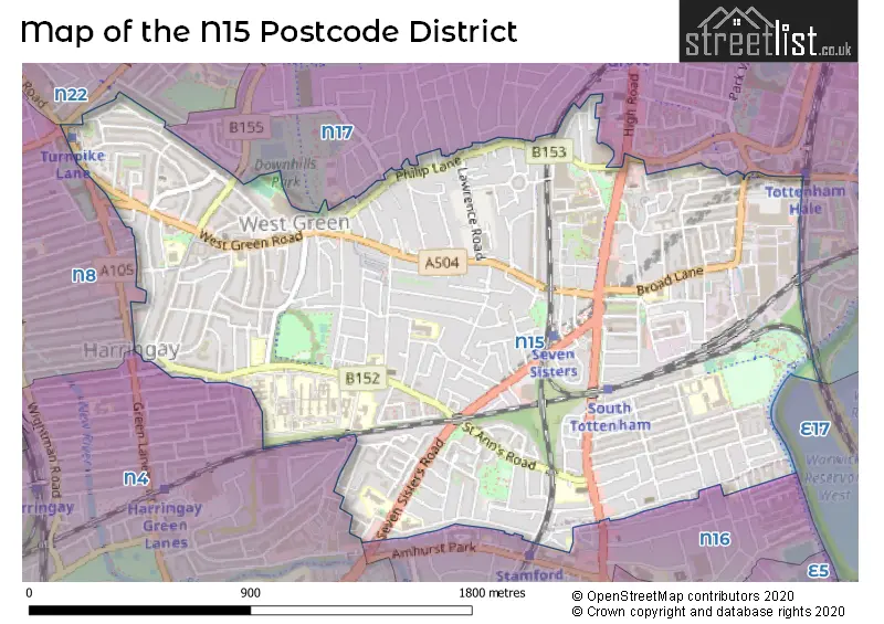
The N15 Postcode shares a border with N16 (HACKNEY), N17 (TOTTENHAM), N4 (HACKNEY, HORNSEY, ISLINGTON), N8 (HORNSEY) and N22 (WOOD GREEN).
The primary settlement in the N15 postcode district is Haringey. It is located in the county of Greater London, in the country of England. The most significant postal town in this district is London.
For the district N15, we have data on 5 postcode sectors. Here's a breakdown: The sector N15 3, covers Haringey in Greater London. The sector N15 4, covers Haringey in Greater London. The sector N15 5, covers Haringey in Greater London. The sector N15 6, covers Haringey in Greater London. The sector N15 9 is non-geographic. It's often designated for PO Boxes, large organisations, or special services.

Map of the N15 Postcode District
Explore the N15 postcode district by using our free interactive map.
When it comes to local government, postal geography often disregards political borders. However, for a breakdown in the N15 District: the district mostly encompasses the Haringey London Boro (688 postcodes), followed by the Islington London Boro area (14 postcodes), and finally, the Hackney London Boro area (5 postcodes).
Recent House Sales in N15
| Date | Price | Address |
|---|---|---|
| 05/10/2023 | £275,000 | Culross Close, London, N15 3RH |
| 29/09/2023 | £725,000 | Hanover Road, London, N15 4DL |
| 25/09/2023 | £545,000 | Howard Road, London, N15 6NS |
| 22/09/2023 | £785,000 | Dorset Road, South Tottenham, London, N15 5AJ |
| 22/09/2023 | £995,000 | St Anns Road, London, N15 3ST |
| 08/09/2023 | £420,000 | Abbotsford Avenue, London, N15 3BS |
| 08/09/2023 | £378,000 | Woodlands Park Road, South Tottenham, London, N15 3RT |
| 04/09/2023 | £435,000 | Bathurst Square, London, N15 4FA |
| 01/09/2023 | £750,000 | Beaconsfield Road, London, N15 4SJ |
| 01/09/2023 | £200,000 | Tynemouth Road, London, N15 4AT |
Weather Forecast for N15
Press Button to Show Forecast for Harringay
| Time Period | Icon | Description | Temperature | Rain Probability | Wind |
|---|---|---|---|---|---|
| 06:00 to 09:00 | Heavy rain | 7.0°C (feels like 4.0°C) | 87.00% | NE 9 mph | |
| 09:00 to 12:00 | Light rain | 8.0°C (feels like 5.0°C) | 44.00% | NE 9 mph | |
| 12:00 to 15:00 | Overcast | 11.0°C (feels like 9.0°C) | 13.00% | ENE 9 mph | |
| 15:00 to 18:00 | Cloudy | 12.0°C (feels like 11.0°C) | 14.00% | NE 7 mph | |
| 18:00 to 21:00 | Light rain | 11.0°C (feels like 10.0°C) | 61.00% | NE 9 mph | |
| 21:00 to 00:00 | Heavy rain | 10.0°C (feels like 8.0°C) | 89.00% | NE 9 mph |
Press Button to Show Forecast for Harringay
| Time Period | Icon | Description | Temperature | Rain Probability | Wind |
|---|---|---|---|---|---|
| 00:00 to 03:00 | Heavy rain | 9.0°C (feels like 7.0°C) | 92.00% | NNE 11 mph | |
| 03:00 to 06:00 | Heavy rain | 9.0°C (feels like 7.0°C) | 92.00% | NE 9 mph | |
| 06:00 to 09:00 | Heavy rain | 9.0°C (feels like 7.0°C) | 91.00% | NNW 7 mph | |
| 09:00 to 12:00 | Heavy rain | 9.0°C (feels like 7.0°C) | 83.00% | WNW 9 mph | |
| 12:00 to 15:00 | Light rain | 10.0°C (feels like 7.0°C) | 56.00% | W 13 mph | |
| 15:00 to 18:00 | Overcast | 10.0°C (feels like 8.0°C) | 16.00% | W 11 mph | |
| 18:00 to 21:00 | Cloudy | 11.0°C (feels like 9.0°C) | 8.00% | WSW 9 mph | |
| 21:00 to 00:00 | Partly cloudy (night) | 10.0°C (feels like 8.0°C) | 4.00% | SW 7 mph |
Press Button to Show Forecast for Harringay
| Time Period | Icon | Description | Temperature | Rain Probability | Wind |
|---|---|---|---|---|---|
| 00:00 to 03:00 | Clear night | 8.0°C (feels like 7.0°C) | 2.00% | SW 4 mph | |
| 03:00 to 06:00 | Clear night | 7.0°C (feels like 5.0°C) | 1.00% | SSW 4 mph | |
| 06:00 to 09:00 | Sunny day | 7.0°C (feels like 6.0°C) | 1.00% | S 4 mph | |
| 09:00 to 12:00 | Partly cloudy (day) | 12.0°C (feels like 10.0°C) | 1.00% | SSW 9 mph | |
| 12:00 to 15:00 | Cloudy | 15.0°C (feels like 12.0°C) | 6.00% | S 11 mph | |
| 15:00 to 18:00 | Partly cloudy (day) | 16.0°C (feels like 13.0°C) | 2.00% | S 11 mph | |
| 18:00 to 21:00 | Sunny day | 14.0°C (feels like 12.0°C) | 3.00% | S 9 mph | |
| 21:00 to 00:00 | Clear night | 12.0°C (feels like 10.0°C) | 1.00% | SSE 7 mph |
Press Button to Show Forecast for Harringay
| Time Period | Icon | Description | Temperature | Rain Probability | Wind |
|---|---|---|---|---|---|
| 00:00 to 03:00 | Clear night | 10.0°C (feels like 8.0°C) | 1.00% | SE 7 mph | |
| 03:00 to 06:00 | Clear night | 9.0°C (feels like 8.0°C) | 2.00% | ESE 7 mph | |
| 06:00 to 09:00 | Cloudy | 9.0°C (feels like 8.0°C) | 7.00% | ESE 7 mph | |
| 09:00 to 12:00 | Cloudy | 13.0°C (feels like 12.0°C) | 6.00% | ESE 7 mph | |
| 12:00 to 15:00 | Cloudy | 16.0°C (feels like 14.0°C) | 8.00% | SE 9 mph | |
| 15:00 to 18:00 | Cloudy | 17.0°C (feels like 15.0°C) | 10.00% | SE 9 mph | |
| 18:00 to 21:00 | Cloudy | 16.0°C (feels like 14.0°C) | 11.00% | SE 9 mph | |
| 21:00 to 00:00 | Cloudy | 13.0°C (feels like 12.0°C) | 15.00% | ESE 7 mph |
Where is the N15 Postcode District?
The postcode district N15 is located in LONDON. It is in close proximity to several nearby towns. To the North, there is Tottenham, which is approximately 0.71 miles away. Wood Green is situated to the North West and is about 2.02 miles away. Walthamstow is located to the East, approximately 2.32 miles away. Hackney is to the South, at a distance of 2.38 miles. Hornsey is situated to the West and is approximately 2.46 miles away. Finally, Islington is found to the South West, around 2.80 miles away. The postcode district N15 is about 5.64 miles away from the center of London.
The district is within the post town of LONDON.
The sector has postcodes within the nation of England.
The N15 Postcode District is covers the following regions.
- Haringey and Islington - Inner London - East - London
- Hackney and Newham - Inner London - East - London
| Postcode Sector | Delivery Office |
|---|---|
| N15 3 | South Tottenham Sdelivery Office |
| N15 4 | South Tottenham Sdelivery Office |
| N15 5 | South Tottenham Sdelivery Office |
| N15 6 | South Tottenham Sdelivery Office |
| N | 1 | 5 | - | X | X | X |
| N | 1 | 5 | Space | Numeric | Letter | Letter |
Current Monthly Rental Prices
| # Bedrooms | Min Price | Max Price | Avg Price |
|---|---|---|---|
| £750 | £2,050 | £1,353 | |
| 1 | £600 | £2,050 | £1,443 |
| 2 | £1,700 | £2,249 | £1,902 |
| 3 | £2,250 | £3,000 | £2,625 |
| 4 | £3,000 | £3,600 | £3,342 |
| 5 | £3,300 | £3,300 | £3,300 |
| 6 | £3,200 | £5,500 | £4,074 |
| 8 | £4,400 | £4,495 | £4,448 |
Current House Prices
| # Bedrooms | Min Price | Max Price | Avg Price |
|---|---|---|---|
| £1,400,000 | £1,400,000 | £1,400,000 | |
| 1 | £170,000 | £490,000 | £351,354 |
| 2 | £275,000 | £675,000 | £473,801 |
| 3 | £350,000 | £1,200,000 | £643,421 |
| 4 | £599,999 | £850,000 | £721,875 |
| 5 | £750,000 | £1,000,000 | £883,333 |
| 9 | £1,900,000 | £1,900,000 | £1,900,000 |
Estate Agents who Operate in the N15 District
| Logo | Name | Brand Name | Address | Contact Number | Total Properties |
|---|---|---|---|---|---|
 | Harringay | Winkworth | 10-11 Grand Parade, Green Lanes, London, N4 1JX | 020 3892 9585 | 20 |
 | London | OpenRent | 39 Great Windmill Street London W1D 7LX | 020 3322 3265 | 12 |
 | Kingsbury Stone | Kingsbury Stone | Percy House, 33-34 Gresse Street, London, W1T 1QU | 020 3909 8926 | 12 |
 | Hackney Wick Fish Island | Savills New Homes | 61 Wallis Road, Hackney Wick, London, E9 5LH | 020 3907 3469 | 10 |
 | Harringay | Property Inc | 7 Turnpike Parade, Green Lanes, London, N15 3EA | 020 3907 9804 | 9 |
| Type of Property | 2018 Average | 2018 Sales | 2017 Average | 2017 Sales | 2016 Average | 2016 Sales | 2015 Average | 2015 Sales |
|---|---|---|---|---|---|---|---|---|
| Detached | £635,000 | 1 | £0 | 0 | £815,000 | 1 | £550,000 | 1 |
| Semi-Detached | £711,375 | 12 | £599,870 | 10 | £605,148 | 10 | £565,571 | 14 |
| Terraced | £638,059 | 156 | £621,451 | 151 | £572,914 | 180 | £513,026 | 208 |
| Flats | £364,496 | 164 | £354,427 | 183 | £329,083 | 266 | £317,538 | 172 |