The N8 postcode district is a postal district located in the N London - N postcode area with a population of 40,057 residents according to the 2021 England and Wales Census.
The area of the N8 postcode district is 1.44 square miles which is 3.73 square kilometres or 922.84 acres.
Currently, the N8 district has about 680 postcode units spread across 4 geographic postcode sectors.
Given that each sector allows for 400 unique postcode combinations, the district has a capacity of 1,600 postcodes. With 680 postcodes already in use, this leaves 920 units available.
The N8 postal code covers the settlement of HORNSEY.
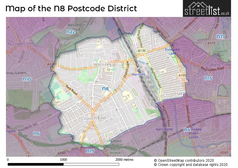
The N8 Postcode shares a border with N10 (HORNSEY, MUSWELL HILL), N6 (HORNSEY, LONDON), N15 (TOTTENHAM), N19 (ISLINGTON), N4 (HACKNEY, HORNSEY, ISLINGTON) and N22 (WOOD GREEN).
The primary settlement in the N8 postcode district is Haringey, which is located in the county of Greater London in England. Other significant settlements in the district include Brent and Islington. The post town associated with the N8 postcode district is London.
For the district N8, we have data on 5 postcode sectors. Here's a breakdown: The sector N8 0, covers Haringey in Greater London. The sector N8 1 is non-geographic. It's often designated for PO Boxes, large organisations, or special services. The sector N8 7, covers Haringey in Greater London. The sector N8 8, covers Haringey in Greater London. The sector N8 9, covers Haringey in Greater London.

Map of the N8 Postcode District
Explore the N8 postcode district by using our free interactive map.
When it comes to local government, postal geography often disregards political borders. However, for a breakdown in the N8 District: the district mostly encompasses the Haringey London Boro (674 postcodes), followed by the Brent London Boro area (13 postcodes), and finally, the Islington London Boro area (6 postcodes).
Recent House Sales in N8
| Date | Price | Address |
|---|---|---|
| 16/10/2023 | £450,000 | Church Lane, Hornsey, London, N8 7BT |
| 13/10/2023 | £370,000 | Tottenham Lane, London, N8 7EE |
| 29/09/2023 | £491,000 | Haringey Park, London, N8 9JB |
| 29/09/2023 | £820,000 | Nelson Road, Hornsey, London, N8 9RN |
| 14/09/2023 | £450,000 | Priory Road, London, N8 8LR |
| 13/09/2023 | £668,686 | High Street, London, N8 7QB |
| 06/09/2023 | £585,000 | Primezone Mews, London, N8 9JP |
| 01/09/2023 | £1,032,000 | Sydney Road, London, N8 0EX |
| 01/09/2023 | £1,060,000 | Bourne Road, London, N8 9HJ |
| 01/09/2023 | £920,000 | Frobisher Road, London, N8 0QX |
Weather Forecast for N8
Press Button to Show Forecast for Harringay
| Time Period | Icon | Description | Temperature | Rain Probability | Wind |
|---|---|---|---|---|---|
| 09:00 to 12:00 | Light rain | 8.0°C (feels like 5.0°C) | 44.00% | NE 9 mph | |
| 12:00 to 15:00 | Overcast | 11.0°C (feels like 9.0°C) | 13.00% | ENE 9 mph | |
| 15:00 to 18:00 | Cloudy | 12.0°C (feels like 11.0°C) | 14.00% | NE 7 mph | |
| 18:00 to 21:00 | Light rain | 11.0°C (feels like 10.0°C) | 61.00% | NE 9 mph | |
| 21:00 to 00:00 | Heavy rain | 10.0°C (feels like 8.0°C) | 89.00% | NE 9 mph |
Press Button to Show Forecast for Harringay
| Time Period | Icon | Description | Temperature | Rain Probability | Wind |
|---|---|---|---|---|---|
| 00:00 to 03:00 | Heavy rain | 9.0°C (feels like 7.0°C) | 92.00% | NNE 11 mph | |
| 03:00 to 06:00 | Heavy rain | 9.0°C (feels like 7.0°C) | 92.00% | NE 9 mph | |
| 06:00 to 09:00 | Heavy rain | 9.0°C (feels like 7.0°C) | 91.00% | NNW 7 mph | |
| 09:00 to 12:00 | Heavy rain | 9.0°C (feels like 7.0°C) | 83.00% | WNW 9 mph | |
| 12:00 to 15:00 | Light rain | 10.0°C (feels like 7.0°C) | 56.00% | W 13 mph | |
| 15:00 to 18:00 | Overcast | 10.0°C (feels like 8.0°C) | 16.00% | W 11 mph | |
| 18:00 to 21:00 | Cloudy | 11.0°C (feels like 9.0°C) | 8.00% | WSW 9 mph | |
| 21:00 to 00:00 | Partly cloudy (night) | 10.0°C (feels like 8.0°C) | 4.00% | SW 7 mph |
Press Button to Show Forecast for Harringay
| Time Period | Icon | Description | Temperature | Rain Probability | Wind |
|---|---|---|---|---|---|
| 00:00 to 03:00 | Clear night | 8.0°C (feels like 7.0°C) | 2.00% | SW 4 mph | |
| 03:00 to 06:00 | Clear night | 7.0°C (feels like 5.0°C) | 1.00% | SSW 4 mph | |
| 06:00 to 09:00 | Sunny day | 7.0°C (feels like 6.0°C) | 1.00% | S 4 mph | |
| 09:00 to 12:00 | Partly cloudy (day) | 12.0°C (feels like 10.0°C) | 1.00% | SSW 9 mph | |
| 12:00 to 15:00 | Cloudy | 15.0°C (feels like 12.0°C) | 6.00% | S 11 mph | |
| 15:00 to 18:00 | Partly cloudy (day) | 16.0°C (feels like 13.0°C) | 2.00% | S 11 mph | |
| 18:00 to 21:00 | Sunny day | 14.0°C (feels like 12.0°C) | 3.00% | S 9 mph | |
| 21:00 to 00:00 | Clear night | 12.0°C (feels like 10.0°C) | 1.00% | SSE 7 mph |
Press Button to Show Forecast for Harringay
| Time Period | Icon | Description | Temperature | Rain Probability | Wind |
|---|---|---|---|---|---|
| 00:00 to 03:00 | Clear night | 10.0°C (feels like 8.0°C) | 1.00% | SE 7 mph | |
| 03:00 to 06:00 | Clear night | 9.0°C (feels like 8.0°C) | 2.00% | ESE 7 mph | |
| 06:00 to 09:00 | Cloudy | 9.0°C (feels like 8.0°C) | 7.00% | ESE 7 mph | |
| 09:00 to 12:00 | Cloudy | 13.0°C (feels like 12.0°C) | 6.00% | ESE 7 mph | |
| 12:00 to 15:00 | Cloudy | 16.0°C (feels like 14.0°C) | 8.00% | SE 9 mph | |
| 15:00 to 18:00 | Cloudy | 17.0°C (feels like 15.0°C) | 10.00% | SE 9 mph | |
| 18:00 to 21:00 | Cloudy | 16.0°C (feels like 14.0°C) | 11.00% | SE 9 mph | |
| 21:00 to 00:00 | Cloudy | 13.0°C (feels like 12.0°C) | 15.00% | ESE 7 mph |
Where is the N8 Postcode District?
The postcode district N8 is located in the town of London. It is closely situated to several nearby towns. To the West, there is Hornsey, which is approximately 0.81 miles away. To the North, there is Wood Green, which is about 1.10 miles away. In the North West, there is Muswell Hill, which is approximately 1.84 miles away. In the East, there is Tottenham, which is about 1.85 miles away. Additionally, to the South, there is Islington, which is approximately 2.59 miles away. The distance from N8 to the centre of London is 5.32 miles.
The district is within the post town of LONDON.
The sector has postcodes within the nation of England.
The N8 Postcode District is covers the following regions.
- Haringey and Islington - Inner London - East - London
- Brent - Outer London - West and North West - London
| Postcode Sector | Delivery Office |
|---|---|
| N8 0 | Hornsey Sdelivery Office |
| N8 1 | Hornsey Sdelivery Office |
| N8 2 | Hornsey Sdelivery Office |
| N8 3 | Hornsey Sdelivery Office |
| N8 4 | Hornsey Sdelivery Office |
| N8 5 | Hornsey Sdelivery Office |
| N8 6 | Hornsey Sdelivery Office |
| N8 7 | Hornsey Sdelivery Office |
| N | 8 | - | X | X | X |
| N | 8 | Space | Numeric | Letter | Letter |
Tourist Attractions within the Postcode Area
We found 3 visitor attractions within the N8 postcode area
| Hornsey Historical Society |
|---|
| Historic Properties |
| Other Historic Property |
| View Hornsey Historical Society on Google Maps |
| Weston Park |
| Historic Properties |
| Historic House / House and Garden / Palace |
| View Weston Park on Google Maps |
| The Manor |
| Historic Properties |
| Historic House / House and Garden / Palace |
| View The Manor on Google Maps |
Current Monthly Rental Prices
| # Bedrooms | Min Price | Max Price | Avg Price |
|---|---|---|---|
| £1,100 | £1,712 | £1,323 | |
| 1 | £975 | £2,383 | £1,767 |
| 2 | £1,600 | £5,950 | £2,514 |
| 3 | £2,400 | £3,500 | £2,938 |
| 4 | £3,250 | £5,300 | £3,821 |
| 6 | £4,500 | £4,500 | £4,500 |
Current House Prices
| # Bedrooms | Min Price | Max Price | Avg Price |
|---|---|---|---|
| £89,375 | £650,000 | £343,875 | |
| 1 | £106,875 | £700,000 | £416,188 |
| 2 | £118,750 | £1,050,000 | £549,203 |
| 3 | £162,500 | £1,550,000 | £800,637 |
| 4 | £795,000 | £1,800,000 | £1,111,944 |
| 5 | £760,000 | £4,250,000 | £1,721,786 |
| 8 | £1,000,000 | £1,000,000 | £1,000,000 |
Estate Agents who Operate in the N8 District
| Logo | Name | Brand Name | Address | Contact Number | Total Properties |
|---|---|---|---|---|---|
 | London | David Astburys Ltd | 15 Park Road London N8 8TE | 020 3889 9033 | 28 |
 | Crouch End | Castles Estate Agents | 12 Topsfield Parade, Tottenham Lane, London, N8 8PR | 020 3893 8716 | 22 |
 | Crouch End | Foxtons | 3-5 Crouch End Hill, London, N8 8DH | 020 3906 2945 | 21 |
 | N8 | Philip Alexander | 52 High Street, Hornsey, London, N8 7NX | 020 3840 3773 | 19 |
 | Crouch End | Kinleigh Folkard & Hayward - Sales | 36-37 Topsfield Parade, Tottenham Lane, London, N8 8PT | 020 3870 5449 | 19 |
| Type of Property | 2018 Average | 2018 Sales | 2017 Average | 2017 Sales | 2016 Average | 2016 Sales | 2015 Average | 2015 Sales |
|---|---|---|---|---|---|---|---|---|
| Detached | £2,475,833 | 3 | £2,280,000 | 2 | £874,435 | 5 | £1,682,414 | 7 |
| Semi-Detached | £1,066,660 | 14 | £1,122,485 | 26 | £1,227,974 | 19 | £1,117,154 | 20 |
| Terraced | £995,940 | 129 | £1,046,071 | 133 | £959,017 | 142 | £924,483 | 160 |
| Flats | £475,719 | 533 | £503,976 | 268 | £480,575 | 308 | £448,873 | 382 |