The N8 9 postcode sector is within the county of Greater London.
Did you know? According to the 2021 Census, the N8 9 postcode sector is home to a bustling 9,821 residents!
Given that each sector allows for 400 unique postcode combinations. Letters C, I, K, M, O and V are not allowed in the last two letters of a postcode. With 175 postcodes already in use, this leaves 225 units available.
The largest settlements in the N8 9 postal code are HORNSEY and ISLINGTON .
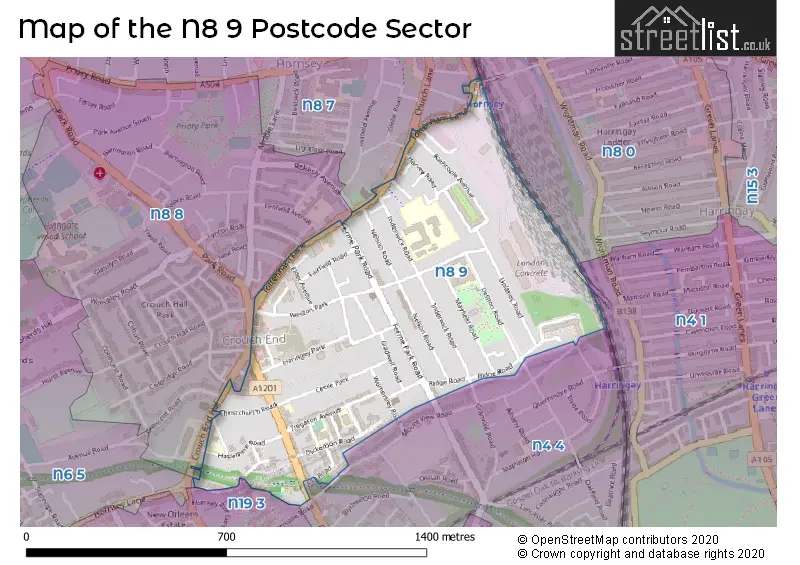
The N8 9 Postcode shares a border with N4 1 (TOTTENHAM , HORNSEY , HACKNEY ), N6 5 (HORNSEY , ISLINGTON , LONDON ), N8 0 (HORNSEY , WOOD GREEN , TOTTENHAM ), N8 7 (HORNSEY ), N8 8 (HORNSEY ), N19 3 (ISLINGTON ) and N4 4 (HORNSEY , ISLINGTON ).
The sector is within the post town of LONDON.
N8 9 is a postcode sector within the N8 postcode district which is within the N North London postcode area.
The Royal Mail delivery office for the N8 9 postal sector is the unknown.
The area of the N8 9 postcode sector is 0.38 square miles which is 0.98 square kilometres or 242.58 square acres.

Map of the N8 9 Postcode Sector
Explore the N8 9 postcode sector by using our free interactive map.
| N | 8 | - | 9 | X | X |
| N | 8 | Space | 9 | Letter | Letter |
Official List of Streets
Haringey (48 Streets)
Unofficial Streets or Alternative Spellings
Haringey
CHURCH LANE CRESCENT ROAD CROUCH END HILL EDISON ROAD GRANVILLE ROAD HAROLD ROAD MIDDLE LANE MOUNT VIEW ROAD OAKFIELD ROAD RIBBLESDALE ROAD ROKESLY AVENUE ROSEBERY GARDENS SLOANE MEWS STAPLETON HALL ROAD BROAD LANE CAIRNCROSS MEWS CHRIST CHURCH ROAD HARVEY MEWS KINGS GATE MEWS OAKFIELD COURT OLIVERS ROW PARKLAND WALK ROSE PLACE SAXON CHASE SUBSTATION ACCESS ROAD VICARAGE WALK WARLTERSVILLE MANSIONSWeather Forecast for N8 9
Press Button to Show Forecast for Harringay
| Time Period | Icon | Description | Temperature | Rain Probability | Wind |
|---|---|---|---|---|---|
| 06:00 to 09:00 | Cloudy | 10.0°C (feels like 8.0°C) | 41.00% | SW 7 mph | |
| 09:00 to 12:00 | Light rain | 10.0°C (feels like 8.0°C) | 62.00% | W 9 mph | |
| 12:00 to 15:00 | Light rain | 8.0°C (feels like 5.0°C) | 58.00% | W 13 mph | |
| 15:00 to 18:00 | Cloudy | 9.0°C (feels like 6.0°C) | 49.00% | WSW 11 mph | |
| 18:00 to 21:00 | Cloudy | 11.0°C (feels like 9.0°C) | 11.00% | SW 9 mph | |
| 21:00 to 00:00 | Clear night | 9.0°C (feels like 8.0°C) | 1.00% | SW 7 mph |
Press Button to Show Forecast for Harringay
| Time Period | Icon | Description | Temperature | Rain Probability | Wind |
|---|---|---|---|---|---|
| 00:00 to 03:00 | Clear night | 8.0°C (feels like 6.0°C) | 0.00% | SW 7 mph | |
| 03:00 to 06:00 | Clear night | 7.0°C (feels like 5.0°C) | 0.00% | SSW 7 mph | |
| 06:00 to 09:00 | Sunny day | 8.0°C (feels like 6.0°C) | 0.00% | S 7 mph | |
| 09:00 to 12:00 | Partly cloudy (day) | 12.0°C (feels like 10.0°C) | 1.00% | S 11 mph | |
| 12:00 to 15:00 | Partly cloudy (day) | 15.0°C (feels like 12.0°C) | 2.00% | S 11 mph | |
| 15:00 to 18:00 | Partly cloudy (day) | 16.0°C (feels like 13.0°C) | 1.00% | S 13 mph | |
| 18:00 to 21:00 | Sunny day | 14.0°C (feels like 12.0°C) | 2.00% | S 9 mph | |
| 21:00 to 00:00 | Clear night | 11.0°C (feels like 10.0°C) | 1.00% | SSE 7 mph |
Press Button to Show Forecast for Harringay
| Time Period | Icon | Description | Temperature | Rain Probability | Wind |
|---|---|---|---|---|---|
| 00:00 to 03:00 | Clear night | 10.0°C (feels like 8.0°C) | 1.00% | SE 7 mph | |
| 03:00 to 06:00 | Clear night | 9.0°C (feels like 8.0°C) | 1.00% | ESE 4 mph | |
| 06:00 to 09:00 | Partly cloudy (day) | 10.0°C (feels like 8.0°C) | 1.00% | ESE 7 mph | |
| 09:00 to 12:00 | Partly cloudy (day) | 14.0°C (feels like 13.0°C) | 6.00% | SE 7 mph | |
| 12:00 to 15:00 | Light rain shower (day) | 16.0°C (feels like 14.0°C) | 31.00% | SE 9 mph | |
| 15:00 to 18:00 | Cloudy | 17.0°C (feels like 15.0°C) | 14.00% | SE 9 mph | |
| 18:00 to 21:00 | Cloudy | 16.0°C (feels like 15.0°C) | 12.00% | SE 7 mph | |
| 21:00 to 00:00 | Cloudy | 13.0°C (feels like 13.0°C) | 12.00% | ESE 7 mph |
Press Button to Show Forecast for Harringay
| Time Period | Icon | Description | Temperature | Rain Probability | Wind |
|---|---|---|---|---|---|
| 00:00 to 03:00 | Cloudy | 12.0°C (feels like 12.0°C) | 14.00% | ESE 4 mph | |
| 03:00 to 06:00 | Cloudy | 11.0°C (feels like 10.0°C) | 11.00% | ESE 4 mph | |
| 06:00 to 09:00 | Fog | 11.0°C (feels like 11.0°C) | 19.00% | E 4 mph | |
| 09:00 to 12:00 | Cloudy | 14.0°C (feels like 14.0°C) | 13.00% | ENE 4 mph | |
| 12:00 to 15:00 | Partly cloudy (day) | 17.0°C (feels like 17.0°C) | 12.00% | E 4 mph | |
| 15:00 to 18:00 | Cloudy | 19.0°C (feels like 18.0°C) | 14.00% | ESE 7 mph | |
| 18:00 to 21:00 | Cloudy | 17.0°C (feels like 17.0°C) | 11.00% | SE 7 mph | |
| 21:00 to 00:00 | Cloudy | 14.0°C (feels like 13.0°C) | 11.00% | N 7 mph |
Schools and Places of Education Within the N8 9 Postcode Sector
Ashmount Primary School
Community school
Crouch Hill Park, London, , N8 9EG
Head: Mr Anthony Carmel
Ofsted Rating: Good
Inspection: 2023-05-18 (346 days ago)
Website: Visit Ashmount Primary School Website
Phone: 02072727145
Number of Pupils: 403
Hornsey School for Girls
Community school
Inderwick Road, London, , N8 9JF
Head: Ms Kuljit Rahelu
Ofsted Rating: Good
Inspection: 2022-03-17 (773 days ago)
Website: Visit Hornsey School for Girls Website
Phone: 02083486191
Number of Pupils: 754
Kestrel House School
Other independent special school
104 Crouch Hill, London, , N8 9EA
Head: Ms Lorna Bailey
Ofsted Rating: Outstanding
Inspection: 2023-03-30 (395 days ago)
Website: Visit Kestrel House School Website
Phone: 02083488500
Number of Pupils: 39
St Gildas' Catholic Junior School
Voluntary aided school
Oakington Way, London, , N8 9EP
Head: Mr Peter O'Shannessy
Ofsted Rating: Good
Inspection: 2019-02-27 (1887 days ago)
Website: Visit St Gildas' Catholic Junior School Website
Phone: 02083481902
Number of Pupils: 121
St Peter-in-Chains RC Infant School
Voluntary aided school
Elm Grove, London, , N8 9AJ
Head: Mr Peter O'Shannessy
Ofsted Rating: Good
Inspection: 2019-02-13 (1901 days ago)
Website: Visit St Peter-in-Chains RC Infant School Website
Phone: 02083406789
Number of Pupils: 64
Weston Park Primary School
Community school
Denton Road, London, , N8 9WP
Head: Mrs Katie Coombes
Ofsted Rating: Good
Inspection: 2023-03-01 (424 days ago)
Website: Visit Weston Park Primary School Website
Phone: 02083475000
Number of Pupils: 218
House Prices in the N8 9 Postcode Sector
| Type of Property | 2018 Average | 2018 Sales | 2017 Average | 2017 Sales | 2016 Average | 2016 Sales | 2015 Average | 2015 Sales |
|---|---|---|---|---|---|---|---|---|
| Detached | £2,182,500 | 2 | £0 | 0 | £961,087 | 2 | £2,790,000 | 2 |
| Semi-Detached | £1,290,248 | 3 | £1,970,000 | 2 | £1,445,000 | 5 | £1,356,300 | 5 |
| Terraced | £1,169,153 | 32 | £1,247,208 | 21 | £1,123,823 | 28 | £1,077,434 | 41 |
| Flats | £536,470 | 89 | £527,373 | 87 | £518,550 | 81 | £489,243 | 106 |
Important Postcodes N8 9 in the Postcode Sector
N8 9AJ is the postcode for St Peter In Chains RC Infant School, Elm Grove
N8 9EA is the postcode for Kestrel House School, 104 Crouch Hill
N8 9EG is the postcode for Ashmount Primary School, 83 Crouch Hill
N8 9EP is the postcode for St. Gildas' Catholic Junior School, Oakington Way, St. Gildas RC Junior School, Oakington Way, and BLOCK B, St. Gildas RC Junior School, Oakington Way
N8 9JA is the postcode for Haringey Council, Hornsey Library, Haringey Park, and Hornsey Central Library, Haringey Park, Hornsey
N8 9JF is the postcode for SPORTS HALL, Hornsey School for Girls, Inderwick Road, LIBRARY, Hornsey School for Girls, Inderwick Road, G-BLOCK, Hornsey School for Girls, Inderwick Road, MAIN BLOCK, Hornsey School for Girls, Inderwick Road, PERFORMING ARTS BLOCK, Hornsey School for Girls, Inderwick Road, and Hornsey School for Girls, Inderwick Road
N8 9JJ is the postcode for Haringey Council, Hornsey Town Hall, The Broadway
N8 9LP is the postcode for Hornsey Vale Community Association, Hornsey Vale Community Centre, 60 Mayfield Road
N8 9WP is the postcode for Weston Park Primary School, Denton Road, Hornsey, and Weston Park Primary School, Denton Road
| The N8 9 Sector is within these Local Authorities |
|
|---|---|
| The N8 9 Sector is within these Counties |
|
| The N8 9 Sector is within these Water Company Areas |
|
Tourist Attractions within the N8 9 Postcode Area
We found 1 visitor attractions within the N8 postcode area
| Weston Park |
|---|
| Historic Properties |
| Historic House / House and Garden / Palace |
| View Weston Park on Google Maps |