The N8 7 postcode sector is within the county of Greater London.
Did you know? According to the 2021 Census, the N8 7 postcode sector is home to a bustling 10,855 residents!
Given that each sector allows for 400 unique postcode combinations. Letters C, I, K, M, O and V are not allowed in the last two letters of a postcode. With 187 postcodes already in use, this leaves 213 units available.
The N8 7 postal code covers the settlement of HORNSEY .
The N8 7 Postcode shares a border with N8 0 (HORNSEY , WOOD GREEN , TOTTENHAM ), N8 8 (HORNSEY ), N8 9 (HORNSEY , ISLINGTON ), N10 3 (HORNSEY ), N22 6 (WOOD GREEN , TOTTENHAM ) and N22 7 (WOOD GREEN , HORNSEY ).
The sector is within the post town of LONDON.
N8 7 is a postcode sector within the N8 postcode district which is within the N North London postcode area.
The Royal Mail delivery office for the N8 7 postal sector is the Hornsey Sdelivery Office.
The area of the N8 7 postcode sector is 0.32 square miles which is 0.83 square kilometres or 204.45 square acres.
Waterways within the N8 7 postcode sector include the New River.

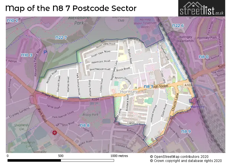
Map of the N8 7 Postcode Sector
Explore the N8 7 postcode sector by using our free interactive map.
| N | 8 | - | 7 | X | X |
| N | 8 | Space | 7 | Letter | Letter |
Official List of Streets
Haringey (51 Streets)
Unofficial Streets or Alternative Spellings
Weather Forecast for N8 7
Press Button to Show Forecast for Harringay
| Time Period | Icon | Description | Temperature | Rain Probability | Wind |
|---|---|---|---|---|---|
| 09:00 to 12:00 | Light rain | 8.0°C (feels like 5.0°C) | 44.00% | NE 9 mph | |
| 12:00 to 15:00 | Overcast | 11.0°C (feels like 9.0°C) | 13.00% | ENE 9 mph | |
| 15:00 to 18:00 | Cloudy | 12.0°C (feels like 11.0°C) | 14.00% | NE 7 mph | |
| 18:00 to 21:00 | Light rain | 11.0°C (feels like 10.0°C) | 61.00% | NE 9 mph | |
| 21:00 to 00:00 | Heavy rain | 10.0°C (feels like 8.0°C) | 89.00% | NE 9 mph |
Press Button to Show Forecast for Harringay
| Time Period | Icon | Description | Temperature | Rain Probability | Wind |
|---|---|---|---|---|---|
| 00:00 to 03:00 | Heavy rain | 9.0°C (feels like 7.0°C) | 92.00% | NNE 11 mph | |
| 03:00 to 06:00 | Heavy rain | 9.0°C (feels like 7.0°C) | 92.00% | NE 9 mph | |
| 06:00 to 09:00 | Heavy rain | 9.0°C (feels like 7.0°C) | 91.00% | NNW 7 mph | |
| 09:00 to 12:00 | Heavy rain | 9.0°C (feels like 7.0°C) | 83.00% | WNW 9 mph | |
| 12:00 to 15:00 | Light rain | 10.0°C (feels like 7.0°C) | 56.00% | W 13 mph | |
| 15:00 to 18:00 | Overcast | 10.0°C (feels like 8.0°C) | 16.00% | W 11 mph | |
| 18:00 to 21:00 | Cloudy | 11.0°C (feels like 9.0°C) | 8.00% | WSW 9 mph | |
| 21:00 to 00:00 | Partly cloudy (night) | 10.0°C (feels like 8.0°C) | 4.00% | SW 7 mph |
Press Button to Show Forecast for Harringay
| Time Period | Icon | Description | Temperature | Rain Probability | Wind |
|---|---|---|---|---|---|
| 00:00 to 03:00 | Clear night | 8.0°C (feels like 7.0°C) | 2.00% | SW 4 mph | |
| 03:00 to 06:00 | Clear night | 7.0°C (feels like 5.0°C) | 1.00% | SSW 4 mph | |
| 06:00 to 09:00 | Sunny day | 7.0°C (feels like 6.0°C) | 1.00% | S 4 mph | |
| 09:00 to 12:00 | Partly cloudy (day) | 12.0°C (feels like 10.0°C) | 1.00% | SSW 9 mph | |
| 12:00 to 15:00 | Cloudy | 15.0°C (feels like 12.0°C) | 6.00% | S 11 mph | |
| 15:00 to 18:00 | Partly cloudy (day) | 16.0°C (feels like 13.0°C) | 2.00% | S 11 mph | |
| 18:00 to 21:00 | Sunny day | 14.0°C (feels like 12.0°C) | 3.00% | S 9 mph | |
| 21:00 to 00:00 | Clear night | 12.0°C (feels like 10.0°C) | 1.00% | SSE 7 mph |
Press Button to Show Forecast for Harringay
| Time Period | Icon | Description | Temperature | Rain Probability | Wind |
|---|---|---|---|---|---|
| 00:00 to 03:00 | Clear night | 10.0°C (feels like 8.0°C) | 1.00% | SE 7 mph | |
| 03:00 to 06:00 | Clear night | 9.0°C (feels like 8.0°C) | 2.00% | ESE 7 mph | |
| 06:00 to 09:00 | Cloudy | 9.0°C (feels like 8.0°C) | 7.00% | ESE 7 mph | |
| 09:00 to 12:00 | Cloudy | 13.0°C (feels like 12.0°C) | 6.00% | ESE 7 mph | |
| 12:00 to 15:00 | Cloudy | 16.0°C (feels like 14.0°C) | 8.00% | SE 9 mph | |
| 15:00 to 18:00 | Cloudy | 17.0°C (feels like 15.0°C) | 10.00% | SE 9 mph | |
| 18:00 to 21:00 | Cloudy | 16.0°C (feels like 14.0°C) | 11.00% | SE 9 mph | |
| 21:00 to 00:00 | Cloudy | 13.0°C (feels like 12.0°C) | 15.00% | ESE 7 mph |
Schools and Places of Education Within the N8 7 Postcode Sector
Campsbourne Infant School
Community school
Nightingale Lane, London, , N8 7AF
Head: Mr Jonathan Smith
Ofsted Rating: Good
Inspection: 2023-04-26 (367 days ago)
Website: Visit Campsbourne Infant School Website
Phone: 02083402064
Number of Pupils: 204
Campsbourne Junior School
Community school
Nightingale Lane, London, , N8 7AF
Head: Mr Jonathan Smith
Ofsted Rating: Good
Inspection: 2023-01-19 (464 days ago)
Website: Visit Campsbourne Junior School Website
Phone: 02083402064
Number of Pupils: 213
Greig City Academy
Academy sponsor led
High Street, London, , N8 7NU
Head: Mr Paul Sutton
Ofsted Rating: Good
Inspection: 2019-11-28 (1612 days ago)
Website: Visit Greig City Academy Website
Phone: 02086090100
Number of Pupils: 1144
North London Rudolf Steiner School
Other independent school
1-3 Campsbourne, London, , N8 7PN
Head: Ms Gabriele Woelfle
Ofsted Rating: Good
Inspection: 2021-05-20 (1073 days ago)
Website: Visit North London Rudolf Steiner School Website
Phone: 02083413770
Number of Pupils: 19
St Mary's CofE Primary School
Voluntary aided school
Church Lane, London, , N8 7BU
Head: Mrs Jane O'Brien
Ofsted Rating: Good
Inspection: 2022-11-10 (534 days ago)
Website: Visit St Mary's CofE Primary School Website
Phone: 02083404898
Number of Pupils: 425
House Prices in the N8 7 Postcode Sector
| Type of Property | 2018 Average | 2018 Sales | 2017 Average | 2017 Sales | 2016 Average | 2016 Sales | 2015 Average | 2015 Sales |
|---|---|---|---|---|---|---|---|---|
| Detached | £0 | 0 | £0 | 0 | £630,000 | 1 | £872,500 | 2 |
| Semi-Detached | £1,312,500 | 2 | £902,438 | 8 | £1,001,333 | 3 | £1,042,500 | 2 |
| Terraced | £894,000 | 23 | £1,027,927 | 33 | £912,442 | 26 | £835,659 | 41 |
| Flats | £461,827 | 346 | £450,200 | 89 | £442,503 | 124 | £414,134 | 129 |
Important Postcodes N8 7 in the Postcode Sector
N8 7AF is the postcode for Campsbourne School, Nightingale Lane, JUNIOR SCHOOL, Campsbourne School, Nightingale Lane, and Campsbourne Infant School, Nightingale Lane
N8 7BU is the postcode for St. Marys School, Church Lane, St Mary's CE Infant School, Church Lane, and St. Marys C of E Primary School, Church Lane
N8 7DY is the postcode for Royal Mail, Hornsey Delivery Office, 44 Tottenham Lane
N8 7EJ is the postcode for Metropolitan Police, Hornsey Police Station, 98 Tottenham Lane, and HORNSEY POLICE STATION, Metropolitan Police, Hornsey Police Station, 98 Tottenham Lane
N8 7NU is the postcode for Greig City Academy, High Street
N8 7QN is the postcode for St. Marys C of E Primary School, Rectory Gardens
N8 7QT is the postcode for MAIN BUILDING, Territorial Army, 2 Priory Road
| The N8 7 Sector is within these Local Authorities |
|
|---|---|
| The N8 7 Sector is within these Counties |
|
| The N8 7 Sector is within these Water Company Areas |
|
Tourist Attractions within the N8 7 Postcode Area
We found 2 visitor attractions within the N8 postcode area
| Hornsey Historical Society |
|---|
| Historic Properties |
| Other Historic Property |
| View Hornsey Historical Society on Google Maps |
| The Manor |
| Historic Properties |
| Historic House / House and Garden / Palace |
| View The Manor on Google Maps |