The N19 3 postcode sector is within the county of Greater London.
Did you know? According to the 2021 Census, the N19 3 postcode sector is home to a bustling 13,665 residents!
Given that each sector allows for 400 unique postcode combinations. Letters C, I, K, M, O and V are not allowed in the last two letters of a postcode. With 234 postcodes already in use, this leaves 166 units available.
The N19 3 postal code covers the settlement of ISLINGTON .
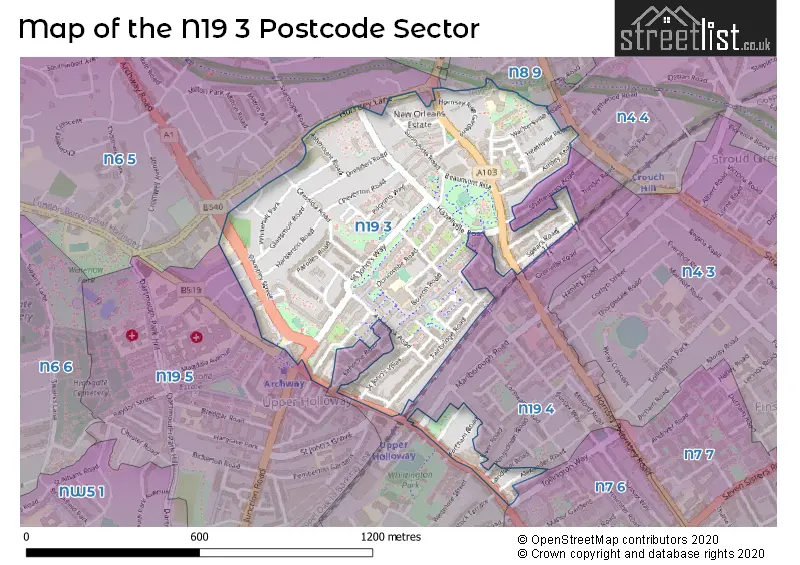
The N19 3 Postcode shares a border with N6 5 (HORNSEY , ISLINGTON , LONDON ), N7 6 (ISLINGTON ), N8 9 (HORNSEY , ISLINGTON ), N19 5 (ISLINGTON , LONDON ), N19 4 (ISLINGTON ) and N4 4 (HORNSEY , ISLINGTON ).
The sector is within the post town of LONDON.
N19 3 is a postcode sector within the N19 postcode district which is within the N North London postcode area.
The Royal Mail delivery office for the N19 3 postal sector is the Upper Holloway Sdelivery Office.
The area of the N19 3 postcode sector is 0.34 square miles which is 0.89 square kilometres or 220.00 square acres.


Map of the N19 3 Postcode Sector
Explore the N19 3 postcode sector by using our free interactive map.
| N | 1 | 9 | - | 3 | X | X |
| N | 1 | 9 | Space | 3 | Letter | Letter |
Official List of Streets
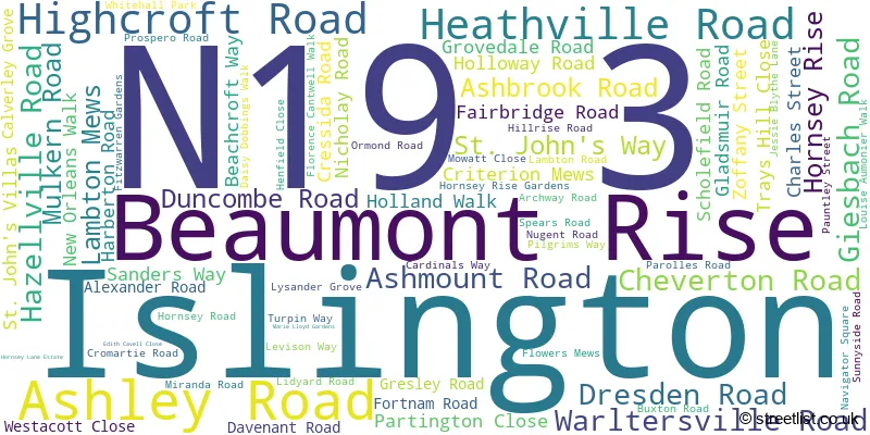
Islington (73 Streets)
Unofficial Streets or Alternative Spellings
Islington
BOOTHBY ROAD BYWORTH WALK COURTAULD ROAD DESPARD ROAD ELTHORNE ROAD KINGSDOWN ROAD KIVER ROAD LANDSEER ROAD MARLBOROUGH ROAD MARLBOROUGH YARD OLD FORGE ROAD PEMBERTON GARDENS SHAFTESBURY ROAD SUSSEX WAY TAVISTOCK TERRACE WATERLOW ROAD WINDERMERE ROAD WITLEY ROADHaringey
ARCHWAY ROAD BLYTHWOOD ROAD CROUCH HILL HANNAY LANE HORNSEY LANE RIDGEWAY GARDENS DAISY DOBBING WALK EDITH TURBEVILLE COURT EMILY HEARTWELL COURT HILLRISE MANSIONS LYSANDER MEWS MARY KINGSLEY COURT MIRIAM PRICE COURT PARKLAND WALK PEGASUS COURT SANDRIDGE STREET SCHOLARS COURT ST JOHNS GROVE TOLLHOUSE WAY WALLACE WAY WARLTERSVILLE MANSIONSCamden
HIGHGATE HILLWeather Forecast for N19 3
Press Button to Show Forecast for Harringay
| Time Period | Icon | Description | Temperature | Rain Probability | Wind |
|---|---|---|---|---|---|
| 00:00 to 03:00 | Cloudy | 7.0°C (feels like 4.0°C) | 5.00% | NE 7 mph | |
| 03:00 to 06:00 | Cloudy | 5.0°C (feels like 3.0°C) | 4.00% | NE 7 mph | |
| 06:00 to 09:00 | Cloudy | 5.0°C (feels like 2.0°C) | 4.00% | NE 7 mph | |
| 09:00 to 12:00 | Partly cloudy (day) | 8.0°C (feels like 6.0°C) | 2.00% | ENE 7 mph | |
| 12:00 to 15:00 | Cloudy | 11.0°C (feels like 10.0°C) | 9.00% | E 4 mph | |
| 15:00 to 18:00 | Overcast | 11.0°C (feels like 10.0°C) | 13.00% | ENE 7 mph | |
| 18:00 to 21:00 | Cloudy | 10.0°C (feels like 9.0°C) | 11.00% | E 7 mph | |
| 21:00 to 00:00 | Cloudy | 7.0°C (feels like 5.0°C) | 11.00% | E 7 mph |
Press Button to Show Forecast for Harringay
| Time Period | Icon | Description | Temperature | Rain Probability | Wind |
|---|---|---|---|---|---|
| 00:00 to 03:00 | Cloudy | 6.0°C (feels like 3.0°C) | 14.00% | ENE 7 mph | |
| 03:00 to 06:00 | Cloudy | 5.0°C (feels like 3.0°C) | 18.00% | NE 7 mph | |
| 06:00 to 09:00 | Cloudy | 6.0°C (feels like 3.0°C) | 21.00% | NE 7 mph | |
| 09:00 to 12:00 | Overcast | 10.0°C (feels like 8.0°C) | 19.00% | ENE 9 mph | |
| 12:00 to 15:00 | Cloudy | 12.0°C (feels like 10.0°C) | 18.00% | E 9 mph | |
| 15:00 to 18:00 | Light rain | 12.0°C (feels like 10.0°C) | 52.00% | E 11 mph | |
| 18:00 to 21:00 | Light rain | 11.0°C (feels like 9.0°C) | 53.00% | ENE 9 mph | |
| 21:00 to 00:00 | Light rain | 10.0°C (feels like 7.0°C) | 51.00% | ENE 11 mph |
Press Button to Show Forecast for Harringay
| Time Period | Icon | Description | Temperature | Rain Probability | Wind |
|---|---|---|---|---|---|
| 00:00 to 03:00 | Light rain | 9.0°C (feels like 7.0°C) | 54.00% | NE 9 mph | |
| 03:00 to 06:00 | Light rain | 10.0°C (feels like 8.0°C) | 56.00% | ESE 9 mph | |
| 06:00 to 09:00 | Overcast | 10.0°C (feels like 8.0°C) | 51.00% | SE 7 mph | |
| 09:00 to 12:00 | Light rain shower (day) | 11.0°C (feels like 9.0°C) | 46.00% | SE 9 mph | |
| 12:00 to 15:00 | Heavy rain shower (day) | 13.0°C (feels like 11.0°C) | 61.00% | SSW 9 mph | |
| 15:00 to 18:00 | Light rain shower (day) | 14.0°C (feels like 12.0°C) | 42.00% | SW 11 mph | |
| 18:00 to 21:00 | Cloudy | 12.0°C (feels like 10.0°C) | 17.00% | SW 11 mph | |
| 21:00 to 00:00 | Cloudy | 10.0°C (feels like 9.0°C) | 8.00% | SW 7 mph |
Schools and Places of Education Within the N19 3 Postcode Sector
City of London Academy, Highgate Hill
Free schools
Holland Walk, Duncombe Road, London, , N19 3EU
Head: Mr Prince Gennuh
Ofsted Rating: Requires improvement
Inspection: 2022-01-19 (828 days ago)
Website: Visit City of London Academy, Highgate Hill Website
Phone: 02072813536
Number of Pupils: 675
Margaret McMillan Nursery School
Local authority nursery school
Hornsey Rise, London, , N19 3SF
Head: Mrs K Smith
Ofsted Rating: Good
Inspection: 2021-10-19 (920 days ago)
Website: Visit Margaret McMillan Nursery School Website
Phone: 02072812745
Number of Pupils: 89
The Bridge Satellite Provision
Free schools special
Duncombe Road, London, , N19 3DL
Head: Ms Rosie Whur
Ofsted Rating: Good
Inspection: 2022-02-23 (793 days ago)
Website: Visit The Bridge Satellite Provision Website
Phone: 02076191000
Number of Pupils: 29

House Prices in the N19 3 Postcode Sector
| Type of Property | 2018 Average | 2018 Sales | 2017 Average | 2017 Sales | 2016 Average | 2016 Sales | 2015 Average | 2015 Sales |
|---|---|---|---|---|---|---|---|---|
| Detached | £0 | 0 | £960,000 | 1 | £0 | 0 | £1,950,000 | 1 |
| Semi-Detached | £0 | 0 | £1,376,750 | 2 | £851,445 | 4 | £310,000 | 1 |
| Terraced | £913,671 | 17 | £1,026,749 | 19 | £1,054,529 | 17 | £896,528 | 30 |
| Flats | £473,561 | 73 | £488,105 | 57 | £503,174 | 90 | £429,872 | 94 |
Important Postcodes N19 3 in the Postcode Sector
N19 3BH is the postcode for Ashmount School, Ashmount Road
N19 3EU is the postcode for City Of London Academy N19 3EU, Holland Walk, Islington, City of London Highgate Hill Academy, Holland Walk, Duncombe Road, and CITY OF LONDON ACADEMY HIGHGATE HILL, HOLLAND WALK, ISLINGTON
N19 3RQ is the postcode for Islington Council, Islington Outlook
N19 3SF is the postcode for Margaret McMillan Nursery School, Hornsey Rise, and Margaret McMillan Nursery, 31 Hornsey Rise, Islington
N19 3TA is the postcode for Highview Community Resettlement Project, 30 Sunnyside Road
N19 3YU is the postcode for Hornsey Rise Health Centre, Hornsey Rise, and Camden & Islington Community Health Service N H S Trust, Hornsey Rise Health Centre, Hornsey Rise
| The N19 3 Sector is within these Local Authorities |
|
|---|---|
| The N19 3 Sector is within these Counties |
|
| The N19 3 Sector is within these Water Company Areas |
|