The N15 4 postcode sector is within the county of Greater London.
Did you know? According to the 2021 Census, the N15 4 postcode sector is home to a bustling 12,724 residents!
Given that each sector allows for 400 unique postcode combinations. Letters C, I, K, M, O and V are not allowed in the last two letters of a postcode. With 208 postcodes already in use, this leaves 192 units available.
The N15 4 postal code covers the settlement of TOTTENHAM .
The N15 4 Postcode shares a border with N15 5 (TOTTENHAM ), N17 9 (TOTTENHAM ), E17 7 (WALTHAMSTOW ), N15 3 (TOTTENHAM ), N15 6 (TOTTENHAM ) and N17 6 (TOTTENHAM ).
The sector is within the post town of LONDON.
N15 4 is a postcode sector within the N15 postcode district which is within the N North London postcode area.
The Royal Mail delivery office for the N15 4 postal sector is the South Tottenham Sdelivery Office.
The area of the N15 4 postcode sector is 0.46 square miles which is 1.18 square kilometres or 292.34 square acres.
Waterways within the N15 4 postcode sector include the River Lea Navigation.

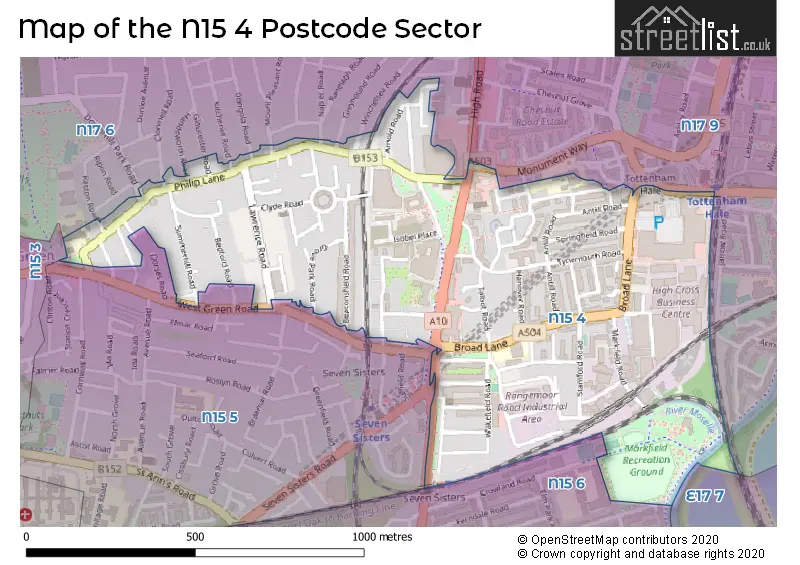
Map of the N15 4 Postcode Sector
Explore the N15 4 postcode sector by using our free interactive map.
| N | 1 | 5 | - | 4 | X | X |
| N | 1 | 5 | Space | 4 | Letter | Letter |
Official List of Streets
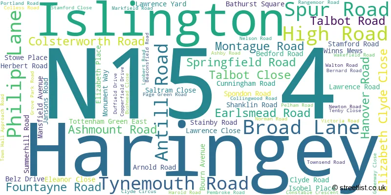
Haringey (71 Streets)
Unofficial Streets or Alternative Spellings
Haringey
BELZ DRIVE CLONMELL ROAD DONGOLA ROAD DOWNHILLS PARK ROAD FERRY LANE GLOUCESTER ROAD GREYHOUND ROAD HANDSWORTH ROAD KESTON ROAD KITCHENER ROAD MOUNT PLEASANT ROAD NAPIER ROAD STONEMASONS CLOSE WEST GREEN ROAD WINCHELSEA ROAD BLENHEIM RISE BRAMBLE CLOSE ENTERPRISE ROW FAIRWEATHER CLOSE LEA COURT PAGE GREEN TERRACE PORTLAND PLACE TOTTENHAM GREEN EAST SOUTH SIDEHackney
SEVEN SISTERS ROADWeather Forecast for N15 4
Press Button to Show Forecast for Tottenham Hotspur F.C.
| Time Period | Icon | Description | Temperature | Rain Probability | Wind |
|---|---|---|---|---|---|
| 09:00 to 12:00 | Light rain | 11.0°C (feels like 9.0°C) | 61.00% | WSW 9 mph | |
| 12:00 to 15:00 | Light rain | 8.0°C (feels like 5.0°C) | 58.00% | W 13 mph | |
| 15:00 to 18:00 | Cloudy | 9.0°C (feels like 6.0°C) | 49.00% | WSW 11 mph | |
| 18:00 to 21:00 | Cloudy | 11.0°C (feels like 9.0°C) | 46.00% | SW 9 mph | |
| 21:00 to 00:00 | Clear night | 9.0°C (feels like 8.0°C) | 1.00% | SW 7 mph |
Press Button to Show Forecast for Tottenham Hotspur F.C.
| Time Period | Icon | Description | Temperature | Rain Probability | Wind |
|---|---|---|---|---|---|
| 00:00 to 03:00 | Clear night | 8.0°C (feels like 7.0°C) | 0.00% | SW 7 mph | |
| 03:00 to 06:00 | Clear night | 7.0°C (feels like 5.0°C) | 0.00% | SSW 7 mph | |
| 06:00 to 09:00 | Sunny day | 8.0°C (feels like 6.0°C) | 0.00% | S 7 mph | |
| 09:00 to 12:00 | Partly cloudy (day) | 12.0°C (feels like 10.0°C) | 1.00% | S 11 mph | |
| 12:00 to 15:00 | Partly cloudy (day) | 15.0°C (feels like 12.0°C) | 2.00% | S 11 mph | |
| 15:00 to 18:00 | Partly cloudy (day) | 16.0°C (feels like 13.0°C) | 1.00% | S 13 mph | |
| 18:00 to 21:00 | Sunny day | 14.0°C (feels like 12.0°C) | 2.00% | S 9 mph | |
| 21:00 to 00:00 | Clear night | 11.0°C (feels like 10.0°C) | 1.00% | SSE 7 mph |
Press Button to Show Forecast for Tottenham Hotspur F.C.
| Time Period | Icon | Description | Temperature | Rain Probability | Wind |
|---|---|---|---|---|---|
| 00:00 to 03:00 | Clear night | 10.0°C (feels like 9.0°C) | 1.00% | SE 7 mph | |
| 03:00 to 06:00 | Clear night | 9.0°C (feels like 8.0°C) | 1.00% | ESE 4 mph | |
| 06:00 to 09:00 | Partly cloudy (day) | 10.0°C (feels like 8.0°C) | 1.00% | ESE 7 mph | |
| 09:00 to 12:00 | Partly cloudy (day) | 14.0°C (feels like 13.0°C) | 6.00% | SE 7 mph | |
| 12:00 to 15:00 | Light rain shower (day) | 16.0°C (feels like 14.0°C) | 31.00% | SE 9 mph | |
| 15:00 to 18:00 | Cloudy | 17.0°C (feels like 15.0°C) | 14.00% | SE 9 mph | |
| 18:00 to 21:00 | Cloudy | 16.0°C (feels like 15.0°C) | 12.00% | SE 7 mph | |
| 21:00 to 00:00 | Cloudy | 13.0°C (feels like 13.0°C) | 12.00% | ESE 7 mph |
Press Button to Show Forecast for Tottenham Hotspur F.C.
| Time Period | Icon | Description | Temperature | Rain Probability | Wind |
|---|---|---|---|---|---|
| 00:00 to 03:00 | Cloudy | 12.0°C (feels like 12.0°C) | 14.00% | ESE 4 mph | |
| 03:00 to 06:00 | Cloudy | 11.0°C (feels like 10.0°C) | 11.00% | ESE 4 mph | |
| 06:00 to 09:00 | Fog | 11.0°C (feels like 11.0°C) | 19.00% | E 4 mph | |
| 09:00 to 12:00 | Cloudy | 14.0°C (feels like 14.0°C) | 13.00% | ENE 4 mph | |
| 12:00 to 15:00 | Partly cloudy (day) | 17.0°C (feels like 17.0°C) | 12.00% | E 4 mph | |
| 15:00 to 18:00 | Cloudy | 19.0°C (feels like 18.0°C) | 14.00% | ESE 7 mph | |
| 18:00 to 21:00 | Cloudy | 17.0°C (feels like 17.0°C) | 11.00% | SE 7 mph | |
| 21:00 to 00:00 | Cloudy | 14.0°C (feels like 14.0°C) | 11.00% | N 7 mph |
Schools and Places of Education Within the N15 4 Postcode Sector
Ambitious College
Special post 16 institution
Pears Campus At the College of North East London, London, , N15 4RX
Head: Mrs Vivienne Berkeley
Ofsted Rating: Good
Inspection: 2023-06-23 (310 days ago)
Website: Visit Ambitious College Website
Phone: 02038708775
Number of Pupils: 0
Earlsmead Primary School
Community school
Broad Lane, London, , N15 4PW
Head: Ms Hina Shah
Ofsted Rating: Good
Inspection: 2022-09-15 (591 days ago)
Website: Visit Earlsmead Primary School Website
Phone: 02088087915
Number of Pupils: 478
Harris Primary Academy Philip Lane
Academy sponsor led
Philip Lane, London, , N15 4AB
Head: Miss Lois Longstaff
Ofsted Rating: Outstanding
Inspection: 2019-02-06 (1908 days ago)
Website: Visit Harris Primary Academy Philip Lane Website
Phone: 02088083231
Number of Pupils: 439
Welbourne Primary School
Community school
Stainby Road, London, , N15 4EA
Head: Mr Robert Lane
Ofsted Rating: Requires improvement
Inspection: 2023-06-07 (326 days ago)
Website: Visit Welbourne Primary School Website
Phone: 02088080427
Number of Pupils: 485
House Prices in the N15 4 Postcode Sector
| Type of Property | 2018 Average | 2018 Sales | 2017 Average | 2017 Sales | 2016 Average | 2016 Sales | 2015 Average | 2015 Sales |
|---|---|---|---|---|---|---|---|---|
| Detached | £635,000 | 1 | £0 | 0 | £0 | 0 | £0 | 0 |
| Semi-Detached | £627,500 | 1 | £561,165 | 3 | £722,500 | 2 | £562,400 | 10 |
| Terraced | £530,567 | 29 | £517,844 | 22 | £561,091 | 43 | £525,889 | 56 |
| Flats | £334,158 | 40 | £334,265 | 54 | £331,336 | 120 | £297,705 | 55 |
Important Postcodes N15 4 in the Postcode Sector
N15 4AB is the postcode for Harris Primary Academy, Philip Lane
N15 4BN is the postcode for Mulberry Junction, Units 1 & 2, 332-334 High Road
N15 4EA is the postcode for Wellbourne Primary School, Stainby Road, and NEW CLASSROOM BLOCK, Wellbourne Primary School, Stainby Road
N15 4JA is the postcode for Tottenham Green Leisure Centre, 1 Philip Lane
N15 4PW is the postcode for Earlsmead Primary School, Broad Lane
N15 4RH is the postcode for Haringey Teaching Primary Care Trust, Tynemouth Road Health Centre, 24 Tynemouth Road
N15 4RU is the postcode for The College of Haringey, Enfield and North East London, Tottenham Centre, and College of North East London, Tottenham Centre, High Road
N15 4RY is the postcode for London Borough of Haringey, Tottenham Town Hall, Town Hall Approach Road, and Tottenham Green Centre, Town Hall Approach Road
| The N15 4 Sector is within these Local Authorities |
|
|---|---|
| The N15 4 Sector is within these Counties |
|
| The N15 4 Sector is within these Water Company Areas |
|