The NE17 7 postcode sector lies where the three counties of Durham, Northumberland, and Tyne & Wear meet.
Did you know? According to the 2021 Census, the NE17 7 postcode sector is home to a bustling 4,563 residents!
Given that each sector allows for 400 unique postcode combinations. Letters C, I, K, M, O and V are not allowed in the last two letters of a postcode. With 166 postcodes already in use, this leaves 234 units available.
The largest settlement in the NE17 7 postal code is Chopwell followed by Hamsterley Colliery, and Blackhall Mill.
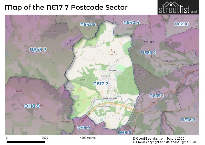
The NE17 7 Postcode shares a border with NE39 2 (ROWLANDS GILL, High Spen, Highfield), DH8 6 (CONSETT, Medomsley, Villa Real), DH8 9 (CONSETT, Blanchland, Castleside), NE39 1 (ROWLANDS GILL, Hamsterley Mill, Lintzford), NE40 4 (RYTON, Greenside, Crawcrook), NE42 5 (PRUDHOE, Cottier Grange), NE43 7 (STOCKSFIELD, Mickley, Newton) and DH8 0 (CONSETT, Shotley Bridge, Blackhill).
The sector is within the post town of NEWCASTLE UPON TYNE.
NE17 7 is a postcode sector within the NE17 postcode district which is within the NE Newcastle upon Tyne postcode area.
The Royal Mail delivery office for the NE17 7 postal sector is the Prudhoe Delivery Office.
The area of the NE17 7 postcode sector is 5.96 square miles which is 15.44 square kilometres or 3,815.46 square acres.
Waterways within the NE17 7 postcode sector include the River Derwent, Stanley Burn, Milkwell Burn.

Map of the NE17 7 Postcode Sector
Explore the NE17 7 postcode sector by using our free interactive map.
| N | E | 1 | 7 | - | 7 | X | X |
| N | E | 1 | 7 | Space | 7 | Letter | Letter |
Official List of Streets
Blackhall Mill (17 Streets)
Hamsterley Colliery (13 Streets)
Chopwell (72 Streets)
Low Westwood (6 Streets)
High Westwood (2 Streets)
Allendale Cottages (1 Streets)
Unofficial Streets or Alternative Spellings
Greenside
LEAD ROADCONSETT
SHAW LANE VINDOMORA ROADWeather Forecast for NE17 7
Press Button to Show Forecast for Powerline Mountain Bike Trail
| Time Period | Icon | Description | Temperature | Rain Probability | Wind |
|---|---|---|---|---|---|
| 03:00 to 06:00 | Clear night | -1.0°C (feels like -2.0°C) | 0.00% | WNW 2 mph | |
| 06:00 to 09:00 | Sunny day | 2.0°C (feels like 1.0°C) | 0.00% | NW 2 mph | |
| 09:00 to 12:00 | Cloudy | 7.0°C (feels like 5.0°C) | 5.00% | ENE 4 mph | |
| 12:00 to 15:00 | Cloudy | 9.0°C (feels like 6.0°C) | 6.00% | E 9 mph | |
| 15:00 to 18:00 | Cloudy | 8.0°C (feels like 6.0°C) | 10.00% | E 9 mph | |
| 18:00 to 21:00 | Cloudy | 7.0°C (feels like 4.0°C) | 14.00% | E 7 mph | |
| 21:00 to 00:00 | Partly cloudy (night) | 4.0°C (feels like 3.0°C) | 11.00% | ENE 4 mph |
Press Button to Show Forecast for Powerline Mountain Bike Trail
| Time Period | Icon | Description | Temperature | Rain Probability | Wind |
|---|---|---|---|---|---|
| 00:00 to 03:00 | Light rain shower (night) | 4.0°C (feels like 2.0°C) | 31.00% | N 4 mph | |
| 03:00 to 06:00 | Cloudy | 4.0°C (feels like 2.0°C) | 8.00% | N 4 mph | |
| 06:00 to 09:00 | Cloudy | 5.0°C (feels like 2.0°C) | 18.00% | N 7 mph | |
| 09:00 to 12:00 | Overcast | 6.0°C (feels like 3.0°C) | 16.00% | N 11 mph | |
| 12:00 to 15:00 | Heavy rain | 7.0°C (feels like 4.0°C) | 77.00% | NNW 11 mph | |
| 15:00 to 18:00 | Light rain | 8.0°C (feels like 6.0°C) | 43.00% | NW 9 mph | |
| 18:00 to 21:00 | Partly cloudy (day) | 9.0°C (feels like 7.0°C) | 6.00% | W 7 mph | |
| 21:00 to 00:00 | Clear night | 6.0°C (feels like 3.0°C) | 1.00% | WSW 9 mph |
Press Button to Show Forecast for Powerline Mountain Bike Trail
| Time Period | Icon | Description | Temperature | Rain Probability | Wind |
|---|---|---|---|---|---|
| 00:00 to 03:00 | Clear night | 5.0°C (feels like 2.0°C) | 0.00% | SW 9 mph | |
| 03:00 to 06:00 | Clear night | 4.0°C (feels like 2.0°C) | 7.00% | SSW 7 mph | |
| 06:00 to 09:00 | Partly cloudy (day) | 6.0°C (feels like 3.0°C) | 1.00% | S 7 mph | |
| 09:00 to 12:00 | Partly cloudy (day) | 10.0°C (feels like 8.0°C) | 1.00% | S 11 mph | |
| 12:00 to 15:00 | Cloudy | 13.0°C (feels like 10.0°C) | 5.00% | S 13 mph | |
| 15:00 to 18:00 | Cloudy | 13.0°C (feels like 10.0°C) | 5.00% | S 13 mph | |
| 18:00 to 21:00 | Cloudy | 12.0°C (feels like 10.0°C) | 6.00% | SSE 11 mph | |
| 21:00 to 00:00 | Partly cloudy (night) | 9.0°C (feels like 7.0°C) | 3.00% | SSE 9 mph |
Press Button to Show Forecast for Powerline Mountain Bike Trail
| Time Period | Icon | Description | Temperature | Rain Probability | Wind |
|---|---|---|---|---|---|
| 00:00 to 03:00 | Partly cloudy (night) | 8.0°C (feels like 5.0°C) | 1.00% | SSE 9 mph | |
| 03:00 to 06:00 | Clear night | 6.0°C (feels like 4.0°C) | 4.00% | SE 7 mph | |
| 06:00 to 09:00 | Partly cloudy (day) | 7.0°C (feels like 5.0°C) | 2.00% | SE 7 mph | |
| 09:00 to 12:00 | Cloudy | 11.0°C (feels like 9.0°C) | 7.00% | ESE 9 mph | |
| 12:00 to 15:00 | Cloudy | 13.0°C (feels like 11.0°C) | 10.00% | ESE 11 mph | |
| 15:00 to 18:00 | Partly cloudy (day) | 13.0°C (feels like 11.0°C) | 7.00% | E 11 mph | |
| 18:00 to 21:00 | Cloudy | 11.0°C (feels like 9.0°C) | 10.00% | E 9 mph | |
| 21:00 to 00:00 | Overcast | 9.0°C (feels like 7.0°C) | 12.00% | ENE 7 mph |
Schools and Places of Education Within the NE17 7 Postcode Sector
Chopwell Primary School
Community school
Derwent Street, Newcastle-upon-Tyne, Tyne and Wear, NE17 7HS
Head: Mrs Vic Bruce
Ofsted Rating: Good
Inspection: 2022-04-07 (751 days ago)
Website: Visit Chopwell Primary School Website
Phone: 01207561322
Number of Pupils: 224
House Prices in the NE17 7 Postcode Sector
| Type of Property | 2018 Average | 2018 Sales | 2017 Average | 2017 Sales | 2016 Average | 2016 Sales | 2015 Average | 2015 Sales |
|---|---|---|---|---|---|---|---|---|
| Detached | £228,591 | 11 | £204,750 | 14 | £187,833 | 15 | £176,541 | 11 |
| Semi-Detached | £112,955 | 11 | £105,386 | 11 | £93,500 | 6 | £136,188 | 8 |
| Terraced | £72,331 | 45 | £71,715 | 44 | £72,083 | 47 | £67,959 | 57 |
| Flats | £83,000 | 1 | £88,000 | 2 | £93,000 | 1 | £45,375 | 4 |
Important Postcodes NE17 7 in the Postcode Sector
NE17 7HS is the postcode for Chopwell Cp School, Derwent Street
NE17 7SB is the postcode for Oakfields Health Centre, Hamsterley Colliery
| The NE17 7 Sector is within these Local Authorities |
|
|---|---|
| The NE17 7 Sector is within these Counties |
|
| The NE17 7 Sector is within these Water Company Areas |
|