The NE32 3 postcode sector is within the county of Tyne & Wear.
Did you know? According to the 2021 Census, the NE32 3 postcode sector is home to a bustling 5,106 residents!
Given that each sector allows for 400 unique postcode combinations. Letters C, I, K, M, O and V are not allowed in the last two letters of a postcode. With 182 postcodes already in use, this leaves 218 units available.
The NE32 3 postal code covers the settlement of JARROW.
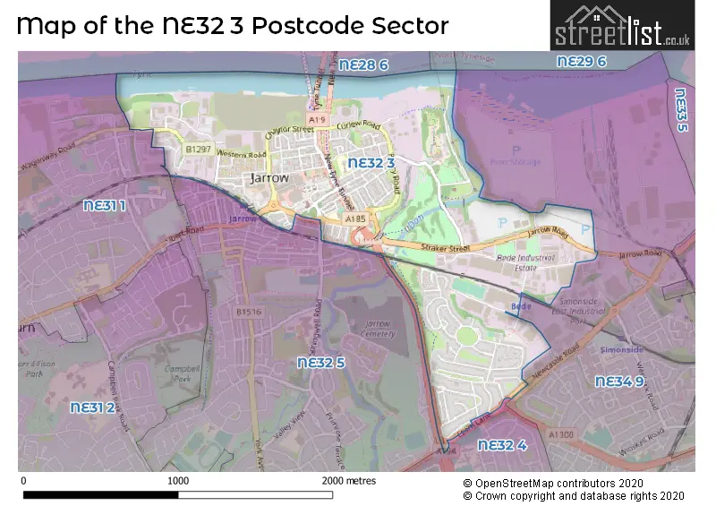
The NE32 3 Postcode shares a border with NE32 4 (JARROW), NE32 5 (JARROW, Monkton Village), NE34 9 (SOUTH SHIELDS) and NE31 1 (HEBBURN).
The sector is within the post town of JARROW.
NE32 3 is a postcode sector within the NE32 postcode district which is within the NE Newcastle upon Tyne postcode area.
The Royal Mail delivery office for the NE32 3 postal sector is the Jarrow Delivery Office.
The area of the NE32 3 postcode sector is 1.09 square miles which is 2.82 square kilometres or 696.39 square acres.
The NE32 3 postcode sector is crossed by the A19 Major A road.
Waterways within the NE32 3 postcode sector include the Don.

Map of the NE32 3 Postcode Sector
Explore the NE32 3 postcode sector by using our free interactive map.
| N | E | 3 | 2 | - | 3 | X | X |
| N | E | 3 | 2 | Space | 3 | Letter | Letter |
Official List of Streets
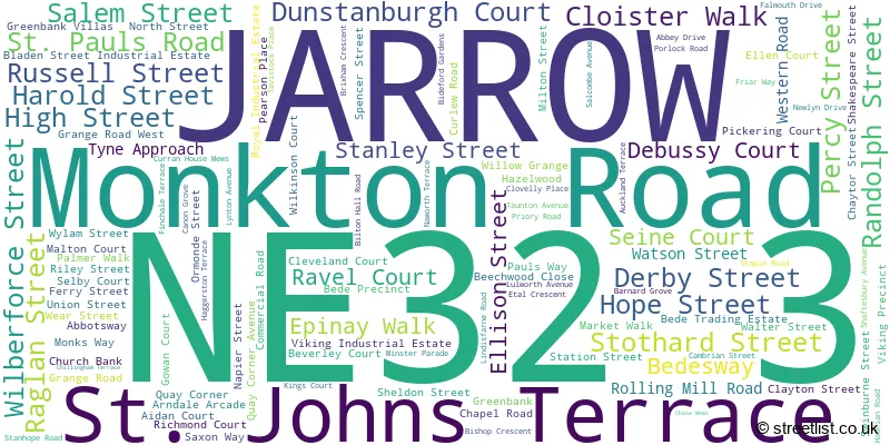
JARROW (114 Streets)
Unofficial Streets or Alternative Spellings
SOUTH SHIELDS
JARROW ROAD NEWCASTLE ROAD TOWERS PLACE ALBERT ROAD BLADEN STREET BURNS STREET CUTHBERT COURT CYCLE TUNNEL DEE STREET DON ROAD EDWARD STREET ELLISON PLACE GRANGE PLACE HANLON COURT HIBERNIAN ROAD HOWARD STREET JARROW BRIDGE JARROW INTERCHANGE LINDISFARNE COURT LINDISFARNE INTERCHANGE LINDISFARNE ROAD (EVEN NUMBERS) MARKET SQUARE MONKTON CYCLEWAY NEW TYNE TUNNEL NEWMARCH STREET PALMER STREET PEDESTRIAN TUNNEL PILGRIMSWAY POTTER STREET SLAKE ROAD STRAKER STREET TYNE STREET TYNE TUNNEL VEHICLE INSPECTION LANE VIKING CENTRE WELLINGTON PLACEJARROW
ALBERT ROAD CONCORDE WAY LEAM LANE MONKTON TERRACE SPENCER STREETJARROW,
SHAFTESBURY AVENUEHEBBURN
BLACKETT STREETWeather Forecast for NE32 3
Press Button to Show Forecast for Jarrow
| Time Period | Icon | Description | Temperature | Rain Probability | Wind |
|---|---|---|---|---|---|
| 09:00 to 12:00 | Partly cloudy (day) | 6.0°C (feels like 4.0°C) | 35.00% | NNE 7 mph | |
| 12:00 to 15:00 | Cloudy | 8.0°C (feels like 6.0°C) | 11.00% | ENE 7 mph | |
| 15:00 to 18:00 | Cloudy | 8.0°C (feels like 6.0°C) | 10.00% | E 7 mph | |
| 18:00 to 21:00 | Sunny day | 7.0°C (feels like 5.0°C) | 4.00% | E 7 mph | |
| 21:00 to 00:00 | Clear night | 4.0°C (feels like 2.0°C) | 2.00% | SE 4 mph |
Press Button to Show Forecast for Jarrow
| Time Period | Icon | Description | Temperature | Rain Probability | Wind |
|---|---|---|---|---|---|
| 00:00 to 03:00 | Partly cloudy (night) | 3.0°C (feels like 1.0°C) | 2.00% | S 4 mph | |
| 03:00 to 06:00 | Clear night | 2.0°C (feels like 0.0°C) | 3.00% | SSW 4 mph | |
| 06:00 to 09:00 | Partly cloudy (day) | 4.0°C (feels like 2.0°C) | 5.00% | SSE 4 mph | |
| 09:00 to 12:00 | Partly cloudy (day) | 8.0°C (feels like 6.0°C) | 7.00% | ESE 7 mph | |
| 12:00 to 15:00 | Partly cloudy (day) | 9.0°C (feels like 7.0°C) | 8.00% | ESE 9 mph | |
| 15:00 to 18:00 | Sunny day | 9.0°C (feels like 6.0°C) | 6.00% | E 11 mph | |
| 18:00 to 21:00 | Partly cloudy (day) | 8.0°C (feels like 5.0°C) | 6.00% | E 11 mph | |
| 21:00 to 00:00 | Cloudy | 6.0°C (feels like 4.0°C) | 10.00% | E 9 mph |
Press Button to Show Forecast for Jarrow
| Time Period | Icon | Description | Temperature | Rain Probability | Wind |
|---|---|---|---|---|---|
| 00:00 to 03:00 | Cloudy | 5.0°C (feels like 3.0°C) | 14.00% | ENE 9 mph | |
| 03:00 to 06:00 | Cloudy | 6.0°C (feels like 3.0°C) | 14.00% | NE 9 mph | |
| 06:00 to 09:00 | Overcast | 7.0°C (feels like 4.0°C) | 17.00% | NE 13 mph | |
| 09:00 to 12:00 | Light rain | 8.0°C (feels like 4.0°C) | 50.00% | NE 16 mph | |
| 12:00 to 15:00 | Light rain | 8.0°C (feels like 5.0°C) | 52.00% | NNE 16 mph | |
| 15:00 to 18:00 | Light rain | 8.0°C (feels like 5.0°C) | 50.00% | NNE 13 mph | |
| 18:00 to 21:00 | Cloudy | 9.0°C (feels like 7.0°C) | 17.00% | N 9 mph | |
| 21:00 to 00:00 | Partly cloudy (night) | 6.0°C (feels like 4.0°C) | 11.00% | ESE 9 mph |
Schools and Places of Education Within the NE32 3 Postcode Sector
Dunn Street Primary School
Community school
Minster Parade, Jarrow, , NE32 3QH
Head: Mrs Alison Burden
Ofsted Rating: Good
Inspection: 2022-05-13 (714 days ago)
Website: Visit Dunn Street Primary School Website
Phone: 01914836619
Number of Pupils: 133
House Prices in the NE32 3 Postcode Sector
| Type of Property | 2018 Average | 2018 Sales | 2017 Average | 2017 Sales | 2016 Average | 2016 Sales | 2015 Average | 2015 Sales |
|---|---|---|---|---|---|---|---|---|
| Detached | £310,000 | 2 | £0 | 0 | £252,500 | 2 | £0 | 0 |
| Semi-Detached | £108,535 | 12 | £97,022 | 20 | £97,594 | 16 | £99,843 | 11 |
| Terraced | £96,948 | 20 | £93,550 | 16 | £61,767 | 6 | £80,267 | 15 |
| Flats | £48,875 | 4 | £59,717 | 9 | £62,122 | 9 | £40,000 | 5 |
Important Postcodes NE32 3 in the Postcode Sector
NE32 3AA is the postcode for Royal Mail, Jarrow Delivery Office, Monkton Road
NE32 3AJ is the postcode for St. Bedes RC Primary School, Harold Street
NE32 3BX is the postcode for 54-64 Ellison Street
NE32 3DS is the postcode for Northumbria Police, Marine Unit, Tyne Approach, Northumbria Police Marine Unit, Tyne Approach, Northumbria Police, International Diving & Marine School, Blackett Street, and Northumbria Police,, Marine Unit,, Tyne Approach,
NE32 3JR is the postcode for South Tyneside and Sunderland NHS Foundation Trust, Palmer Community Hospital, Clayton Street, and Palmer Community Hospital, Clayton Street
NE32 3LE is the postcode for South Tyneside Metropolitan Borough Council, Town Hall, Grange Road
NE32 3QH is the postcode for Dunn Street Primary School, Minster Parade
NE32 3QN is the postcode for Community Centre, Cambrian Street, and South Tyneside Metropolitan Borough Council, Jarrow Branch Library, Cambrian Street
NE32 3RT is the postcode for Low Simonside Community Centre, Taunton Avenue
NE32 3UX is the postcode for South Tyneside NHS Foundation Trust, Palmer Community Hospital
| The NE32 3 Sector is within these Local Authorities |
|
|---|---|
| The NE32 3 Sector is within these Counties |
|
| The NE32 3 Sector is within these Water Company Areas |
|