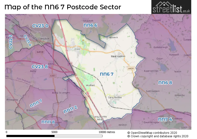
The NN6 7 postcode sector stands on the Northamptonshire and Warwickshire border.
Did you know? According to the 2021 Census, the NN6 7 postcode sector is home to a bustling 9,307 residents!
Given that each sector allows for 400 unique postcode combinations. Letters C, I, K, M, O and V are not allowed in the last two letters of a postcode. With 266 postcodes already in use, this leaves 134 units available.
The largest settlement in the NN6 7 postal code is Long Buckby followed by Crick, and West Haddon.
The NN6 7 Postcode shares a border with NN6 6 (Welford, Naseby, Yelvertoft), NN6 8 (Spratton, East Haddon, Chapel Brampton), NN7 4 (Weedon, Harpole, Kislingbury), NN11 2 (DAVENTRY, Welton, Whilton), CV23 8 (Kilsby, Barby, Willoughby) and CV23 0 (RUGBY, Clifton Upon Dunsmore, Brinklow).
The sector is within the post town of NORTHAMPTON.
NN6 7 is a postcode sector within the NN6 postcode district which is within the NN Northampton postcode area.
The Royal Mail delivery office for the NN6 7 postal sector is the Long Buckby Scale Payment Delivery Office and West Haddelivery Officen Scale Payment Delivery Office and Watford (nn6) Scale Payment Delivery Office and Crick Scale Payment Delivery Office.
The area of the NN6 7 postcode sector is 24.08 square miles which is 62.36 square kilometres or 15,410.63 square acres.
The NN6 7 postcode sector is crossed by the A5 Major A road.
The NN6 7 postcode sector is crossed by the M45 motorway.
The NN6 7 postcode sector is crossed by the M1 motorway.
Waterways within the NN6 7 postcode sector include the Grand Union Canal Leicester Line, Crick Tunnel, Grand Union Canal, Crick Marina.

Map of the NN6 7 Postcode Sector
Explore the NN6 7 postcode sector by using our free interactive map.
| N | N | 6 | - | 7 | X | X |
| N | N | 6 | Space | 7 | Letter | Letter |
Official List of Streets
Daventry Rail Freight Terminal (6 Streets)
Crick (54 Streets)
Long Buckby (95 Streets)
West Haddon (41 Streets)
Watford (14 Streets)
Winwick (1 Streets)
Unofficial Streets or Alternative Spellings
Long Buckby
ST. JOSEPHS COURT ALICE CLOSE ALTHORP ROAD BRIDGE GL14 BYWAY CS8 CRICK BYPASS CRICK INTERCHANGE CROCKWELL HILL GRASS CROFT HENLEY COURT JUBILEE CLOSE LAWRENCE COURT MARRIOTS ROAD OSBOURNE ROAD PYTCHLEY COURT SKIN YARD LANE SOUTH FIELDS DRIVE SPENCER COURT SYLES CLOSE THE PADDOCKS TOWPATH WEST HADDON BYPASSDAVENTRY
LONG BUCKBY ROADHillmorton
CRICK ROADBurbage
WATLING STREETWeather Forecast for NN6 7
Press Button to Show Forecast for Watford (Northamptonshire)
| Time Period | Icon | Description | Temperature | Rain Probability | Wind |
|---|---|---|---|---|---|
| 21:00 to 00:00 | Cloudy | 6.0°C (feels like 3.0°C) | 6.00% | ENE 9 mph |
Press Button to Show Forecast for Watford (Northamptonshire)
| Time Period | Icon | Description | Temperature | Rain Probability | Wind |
|---|---|---|---|---|---|
| 00:00 to 03:00 | Cloudy | 5.0°C (feels like 2.0°C) | 8.00% | ENE 9 mph | |
| 03:00 to 06:00 | Cloudy | 4.0°C (feels like 2.0°C) | 8.00% | ENE 7 mph | |
| 06:00 to 09:00 | Cloudy | 5.0°C (feels like 2.0°C) | 10.00% | NE 9 mph | |
| 09:00 to 12:00 | Light rain | 7.0°C (feels like 4.0°C) | 50.00% | ENE 11 mph | |
| 12:00 to 15:00 | Overcast | 8.0°C (feels like 5.0°C) | 14.00% | ENE 11 mph | |
| 15:00 to 18:00 | Overcast | 9.0°C (feels like 6.0°C) | 14.00% | ENE 11 mph | |
| 18:00 to 21:00 | Overcast | 7.0°C (feels like 4.0°C) | 12.00% | NE 11 mph | |
| 21:00 to 00:00 | Overcast | 6.0°C (feels like 3.0°C) | 34.00% | NE 11 mph |
Press Button to Show Forecast for Watford (Northamptonshire)
| Time Period | Icon | Description | Temperature | Rain Probability | Wind |
|---|---|---|---|---|---|
| 00:00 to 03:00 | Light rain | 6.0°C (feels like 2.0°C) | 58.00% | NNE 13 mph | |
| 03:00 to 06:00 | Heavy rain | 6.0°C (feels like 2.0°C) | 88.00% | N 16 mph | |
| 06:00 to 09:00 | Heavy rain | 6.0°C (feels like 2.0°C) | 90.00% | N 13 mph | |
| 09:00 to 12:00 | Heavy rain | 6.0°C (feels like 3.0°C) | 82.00% | NNW 13 mph | |
| 12:00 to 15:00 | Light rain | 7.0°C (feels like 4.0°C) | 58.00% | WNW 11 mph | |
| 15:00 to 18:00 | Light rain | 9.0°C (feels like 7.0°C) | 45.00% | WNW 9 mph | |
| 18:00 to 21:00 | Cloudy | 9.0°C (feels like 7.0°C) | 8.00% | WSW 7 mph | |
| 21:00 to 00:00 | Clear night | 6.0°C (feels like 4.0°C) | 2.00% | SW 7 mph |
Press Button to Show Forecast for Watford (Northamptonshire)
| Time Period | Icon | Description | Temperature | Rain Probability | Wind |
|---|---|---|---|---|---|
| 00:00 to 03:00 | Clear night | 5.0°C (feels like 2.0°C) | 0.00% | SW 7 mph | |
| 03:00 to 06:00 | Clear night | 3.0°C (feels like 1.0°C) | 1.00% | SSW 7 mph | |
| 06:00 to 09:00 | Sunny day | 5.0°C (feels like 2.0°C) | 1.00% | S 7 mph | |
| 09:00 to 12:00 | Partly cloudy (day) | 10.0°C (feels like 8.0°C) | 1.00% | S 11 mph | |
| 12:00 to 15:00 | Cloudy | 13.0°C (feels like 10.0°C) | 6.00% | S 13 mph | |
| 15:00 to 18:00 | Cloudy | 13.0°C (feels like 11.0°C) | 7.00% | S 11 mph | |
| 18:00 to 21:00 | Sunny day | 12.0°C (feels like 10.0°C) | 1.00% | S 11 mph | |
| 21:00 to 00:00 | Clear night | 8.0°C (feels like 6.0°C) | 1.00% | SSE 7 mph |
Press Button to Show Forecast for Watford (Northamptonshire)
| Time Period | Icon | Description | Temperature | Rain Probability | Wind |
|---|---|---|---|---|---|
| 00:00 to 03:00 | Clear night | 6.0°C (feels like 4.0°C) | 2.00% | SE 7 mph | |
| 03:00 to 06:00 | Clear night | 6.0°C (feels like 4.0°C) | 2.00% | ESE 7 mph | |
| 06:00 to 09:00 | Sunny day | 7.0°C (feels like 5.0°C) | 3.00% | ESE 9 mph | |
| 09:00 to 12:00 | Partly cloudy (day) | 12.0°C (feels like 10.0°C) | 2.00% | ESE 11 mph | |
| 12:00 to 15:00 | Partly cloudy (day) | 15.0°C (feels like 13.0°C) | 5.00% | SE 11 mph | |
| 15:00 to 18:00 | Cloudy | 15.0°C (feels like 13.0°C) | 8.00% | SE 11 mph | |
| 18:00 to 21:00 | Cloudy | 14.0°C (feels like 12.0°C) | 7.00% | ESE 9 mph | |
| 21:00 to 00:00 | Cloudy | 11.0°C (feels like 9.0°C) | 8.00% | ESE 9 mph |
Schools and Places of Education Within the NN6 7 Postcode Sector
Crick Primary School
Community school
Main Road, Northampton, Northamptonshire, NN6 7TU
Head: Mrs Emma Staniforth
Ofsted Rating: Good
Inspection: 2022-02-03 (813 days ago)
Website: Visit Crick Primary School Website
Phone: 01788822633
Number of Pupils: 189
Long Buckby Infant School
Community school
High Street, Northampton, Northamptonshire, NN6 7RE
Head: Mrs Sarah Dugdale
Ofsted Rating: Good
Inspection: 2023-03-22 (401 days ago)
Website: Visit Long Buckby Infant School Website
Phone: 01327842637
Number of Pupils: 132
Long Buckby Junior School
Community school
South Close, Northampton, Northamptonshire, NN6 7PX
Head: Mr Tony Cox
Ofsted Rating: Good
Inspection: 2023-10-18 (191 days ago)
Website: Visit Long Buckby Junior School Website
Phone: 01327842445
Number of Pupils: 196
West Haddon Endowed Church of England Primary School
Voluntary controlled school
The Green, Northampton, Northamptonshire, NN6 7AN
Head: Mr David Rosevear
Ofsted Rating: Good
Inspection: 2020-02-12 (1535 days ago)
Website: Visit West Haddon Endowed Church of England Primary School Website
Phone: 01788510318
Number of Pupils: 243
House Prices in the NN6 7 Postcode Sector
| Type of Property | 2018 Average | 2018 Sales | 2017 Average | 2017 Sales | 2016 Average | 2016 Sales | 2015 Average | 2015 Sales |
|---|---|---|---|---|---|---|---|---|
| Detached | £394,755 | 134 | £387,981 | 162 | £405,222 | 130 | £356,085 | 118 |
| Semi-Detached | £244,543 | 43 | £224,483 | 47 | £227,543 | 56 | £214,417 | 62 |
| Terraced | £193,880 | 39 | £202,973 | 34 | £201,557 | 33 | £192,370 | 33 |
| Flats | £80,625 | 4 | £63,250 | 2 | £123,000 | 3 | £95,000 | 1 |
Important Postcodes NN6 7 in the Postcode Sector
NN6 7AN is the postcode for West Haddon Endowed Primary School, The Green
NN6 7DD is the postcode for Royal Mail, Daventry Rail Freight Terminal
NN6 7PX is the postcode for Long Buckby Junior School, South Close, and Long Buckby Junior School, South Close, Long Buckby
NN6 7QB is the postcode for Doctors Surgery, 24 Station Road
NN6 7RE is the postcode for Long Buckby Infant School, High Street, Long Buckby, and Long Buckby Infant School, High Street
NN6 7SL is the postcode for Units 8-12a, Eldon Way, and Units 14-16, Eldon Way
NN6 7TU is the postcode for Crick Cp School, Main Road, Crick Cp School, Main Road, Crick, and Crick Primary School, Main Road, Crick
| The NN6 7 Sector is within these Local Authorities |
|
|---|---|
| The NN6 7 Sector is within these Counties |
|
| The NN6 7 Sector is within these Water Company Areas |
|