The NN7 4 postcode sector is within the county of Northamptonshire.
Did you know? According to the 2021 Census, the NN7 4 postcode sector is home to a bustling 8,750 residents!
Given that each sector allows for 400 unique postcode combinations. Letters C, I, K, M, O and V are not allowed in the last two letters of a postcode. With 246 postcodes already in use, this leaves 154 units available.
The largest settlement in the NN7 4 postal code is Weedon followed by Harpole, and Kislingbury.
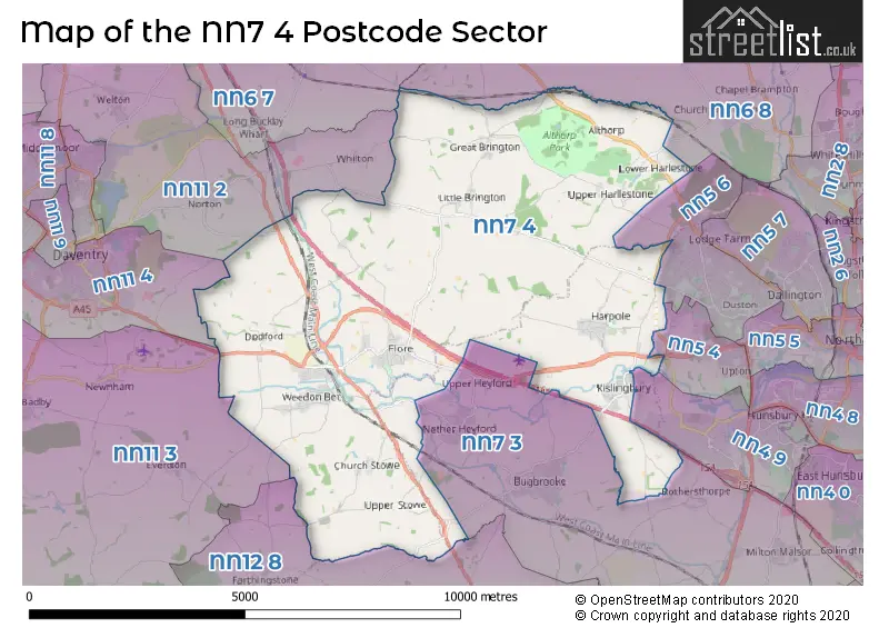
The NN7 4 Postcode shares a border with NN5 4 (NORTHAMPTON, Upton), NN5 6 (NORTHAMPTON, Duston, New Duston), NN11 4 (DAVENTRY, High March Industrial Estate), NN4 9 (NORTHAMPTON, Swan Valley), NN6 7 (Long Buckby, Crick, West Haddon), NN6 8 (Spratton, East Haddon, Chapel Brampton), NN7 3 (Bugbrooke, Blisworth, Nether Heyford), NN11 2 (DAVENTRY, Welton, Whilton), NN11 3 (Woodford Halse, Eydon, Badby) and NN12 8 (Silverstone, Greens Norton, Pattishall).
The sector is within the post town of NORTHAMPTON.
NN7 4 is a postcode sector within the NN7 postcode district which is within the NN Northampton postcode area.
The Royal Mail delivery office for the NN7 4 postal sector is the Northampton Rurals Delivery Office and Nether Heyford Scale Payment Delivery Office and Flore Scale Payment Delivery Office and Kislingbury Scale Payment Delivery Office and Weedelivery Officen Scale Payment Delivery Office.
The area of the NN7 4 postcode sector is 28.52 square miles which is 73.86 square kilometres or 18,250.99 square acres.
The NN7 4 postcode sector is crossed by the M1 motorway.
The NN7 4 postcode sector is crossed by the A5 Major A road.
Waterways within the NN7 4 postcode sector include the River Nene, Grand Union Canal.

Map of the NN7 4 Postcode Sector
Explore the NN7 4 postcode sector by using our free interactive map.
| N | N | 7 | - | 4 | X | X |
| N | N | 7 | Space | 4 | Letter | Letter |
Official List of Streets
Harpole (26 Streets)
Kislingbury (31 Streets)
Great Brington (7 Streets)
Weedon (55 Streets)
Little Brington (8 Streets)
Flore (31 Streets)
Dodford (5 Streets)
Lower Harlestone (4 Streets)
Upper Stowe (3 Streets)
Church Stowe (5 Streets)
Upper Harlestone (2 Streets)
Upper Heyford (1 Streets)
Unofficial Streets or Alternative Spellings
NORTHAMPTON
HARLESTONE ROAD PORT ROAD WEGGS FARM ROADRothersthorpe
KISLINGBURY ROADUpper Heyford
MAIN ROADFlore
YEW TREE GARDENSLong Buckby
BRINGTON ROADNorton
WEEDON LANENether Heyford
FURNACE LANENewnham
WEEDON ROADBurbage
WATLING STREETWeather Forecast for NN7 4
Press Button to Show Forecast for Daventry
| Time Period | Icon | Description | Temperature | Rain Probability | Wind |
|---|---|---|---|---|---|
| 00:00 to 03:00 | Partly cloudy (night) | 3.0°C (feels like 1.0°C) | 1.00% | E 4 mph | |
| 03:00 to 06:00 | Partly cloudy (night) | 2.0°C (feels like 0.0°C) | 1.00% | ENE 4 mph | |
| 06:00 to 09:00 | Partly cloudy (day) | 2.0°C (feels like 0.0°C) | 2.00% | ENE 7 mph | |
| 09:00 to 12:00 | Partly cloudy (day) | 6.0°C (feels like 4.0°C) | 1.00% | ENE 7 mph | |
| 12:00 to 15:00 | Overcast | 9.0°C (feels like 8.0°C) | 9.00% | ENE 4 mph | |
| 15:00 to 18:00 | Overcast | 9.0°C (feels like 8.0°C) | 10.00% | NE 4 mph | |
| 18:00 to 21:00 | Cloudy | 8.0°C (feels like 7.0°C) | 9.00% | NE 4 mph | |
| 21:00 to 00:00 | Cloudy | 5.0°C (feels like 2.0°C) | 11.00% | ENE 7 mph |
Press Button to Show Forecast for Daventry
| Time Period | Icon | Description | Temperature | Rain Probability | Wind |
|---|---|---|---|---|---|
| 00:00 to 03:00 | Cloudy | 4.0°C (feels like 1.0°C) | 12.00% | ENE 7 mph | |
| 03:00 to 06:00 | Cloudy | 3.0°C (feels like 0.0°C) | 13.00% | ENE 7 mph | |
| 06:00 to 09:00 | Cloudy | 4.0°C (feels like 1.0°C) | 14.00% | ENE 7 mph | |
| 09:00 to 12:00 | Cloudy | 7.0°C (feels like 4.0°C) | 18.00% | ENE 9 mph | |
| 12:00 to 15:00 | Overcast | 9.0°C (feels like 7.0°C) | 22.00% | ENE 9 mph | |
| 15:00 to 18:00 | Overcast | 10.0°C (feels like 8.0°C) | 20.00% | ENE 11 mph | |
| 18:00 to 21:00 | Cloudy | 9.0°C (feels like 6.0°C) | 18.00% | ENE 11 mph | |
| 21:00 to 00:00 | Light rain | 7.0°C (feels like 4.0°C) | 53.00% | NE 11 mph |
Press Button to Show Forecast for Daventry
| Time Period | Icon | Description | Temperature | Rain Probability | Wind |
|---|---|---|---|---|---|
| 00:00 to 03:00 | Light rain | 6.0°C (feels like 3.0°C) | 52.00% | NE 11 mph | |
| 03:00 to 06:00 | Heavy rain | 6.0°C (feels like 3.0°C) | 75.00% | NE 11 mph | |
| 06:00 to 09:00 | Heavy rain | 7.0°C (feels like 4.0°C) | 78.00% | NE 9 mph | |
| 09:00 to 12:00 | Light rain | 9.0°C (feels like 7.0°C) | 53.00% | ESE 9 mph | |
| 12:00 to 15:00 | Light rain | 10.0°C (feels like 8.0°C) | 53.00% | WSW 9 mph | |
| 15:00 to 18:00 | Heavy rain shower (day) | 10.0°C (feels like 7.0°C) | 60.00% | SW 11 mph | |
| 18:00 to 21:00 | Light rain shower (day) | 9.0°C (feels like 7.0°C) | 37.00% | SW 9 mph | |
| 21:00 to 00:00 | Cloudy | 7.0°C (feels like 5.0°C) | 11.00% | SW 7 mph |
Schools and Places of Education Within the NN7 4 Postcode Sector
Brington Primary School
Community school
Little Brington, Northampton, Northamptonshire, NN7 4HX
Head: Mrs KIrsten Carpenter
Ofsted Rating: Good
Inspection: 2023-09-13 (226 days ago)
Website: Visit Brington Primary School Website
Phone: 01604770286
Number of Pupils: 43
Flore Church of England Primary School
Voluntary controlled school
The Avenue, Northampton, Northamptonshire, NN7 4LZ
Head: Mrs Sarah Dugdale
Ofsted Rating: Requires improvement
Inspection: 2022-03-09 (779 days ago)
Website: Visit Flore Church of England Primary School Website
Phone: 01327340415
Number of Pupils: 85
Harlestone Primary School
Community school
Church Lane, Northampton, Northamptonshire, NN7 4EN
Head: Mrs Sam Phillips
Ofsted Rating: Good
Inspection: 2023-02-28 (423 days ago)
Website: Visit Harlestone Primary School Website
Phone: 01604842391
Number of Pupils: 51
Harpole Primary School
Voluntary controlled school
Larkhall Lane, Northampton, Northamptonshire, NN7 4DP
Head: Mr Duncan Thorpe
Ofsted Rating: Good
Inspection: 2019-01-16 (1927 days ago)
Website: Visit Harpole Primary School Website
Phone: 01604830072
Number of Pupils: 185
Kislingbury Primary School
Academy converter
High Street, Northampton, Northamptonshire, NN7 4AQ
Head: Mrs Rebecca Osborne
Ofsted Rating: Good
Inspection: 2023-03-08 (415 days ago)
Website: Visit Kislingbury Primary School Website
Phone: 01604831172
Number of Pupils: 122
Weedon Bec Primary School
Academy converter
West Street, Northampton, Northamptonshire, NN7 4QU
Head: Miss Jo Hatt
Ofsted Rating: Requires improvement
Inspection: 2023-06-07 (324 days ago)
Website: Visit Weedon Bec Primary School Website
Phone: 01327340547
Number of Pupils: 212
House Prices in the NN7 4 Postcode Sector
| Type of Property | 2018 Average | 2018 Sales | 2017 Average | 2017 Sales | 2016 Average | 2016 Sales | 2015 Average | 2015 Sales |
|---|---|---|---|---|---|---|---|---|
| Detached | £450,768 | 91 | £427,116 | 80 | £405,261 | 64 | £439,860 | 81 |
| Semi-Detached | £262,705 | 31 | £271,487 | 42 | £246,934 | 43 | £250,722 | 36 |
| Terraced | £234,210 | 19 | £236,556 | 30 | £238,425 | 24 | £219,616 | 38 |
| Flats | £231,500 | 8 | £145,875 | 8 | £136,500 | 4 | £128,417 | 12 |
Important Postcodes NN7 4 in the Postcode Sector
NN7 4AQ is the postcode for Kislingbury VC Primary School, High Street
NN7 4DP is the postcode for Harpole C of E Primary School, Larkhall Lane
NN7 4EN is the postcode for Harlestone Primary School, Church Lane
NN7 4HX is the postcode for Brington Primary School, Little Brington
NN7 4LZ is the postcode for Flore C of E Primary School, The Avenue, and Flore C of E Primary School, The Avenue, Flore
NN7 4PP is the postcode for Driver and Vehicle Standards Agency, Cavalry Hill Industrial Park, Weedon, and Driver and Vehicle Standards Agency, Cavalry Hill Industrial Park
NN7 4QU is the postcode for Weedon Bec Primary School, West Street, Weedon, and Weedon Bec Primary School, West Street
NN7 4RX is the postcode for Doctors Surgery, 57 New Croft
| The NN7 4 Sector is within these Local Authorities |
|
|---|---|
| The NN7 4 Sector is within these Counties |
|
| The NN7 4 Sector is within these Water Company Areas |
|