The PA12 postcode district is a postal district located in the PA Paisley postcode area with a population of 3,414 residents according to the 2011 Scotland Census.
The area of the PA12 postcode district is 22.56 square miles which is 58.44 square kilometres or 14,439.77 acres.
Currently, the PA12 district has about 112 postcode units spread across 1 geographic postcode sectors.
Given that each sector allows for 400 unique postcode combinations, the district has a capacity of 400 postcodes. With 112 postcodes already in use, this leaves 288 units available.
The PA12 postal code covers the settlement of LOCHWINNOCH.
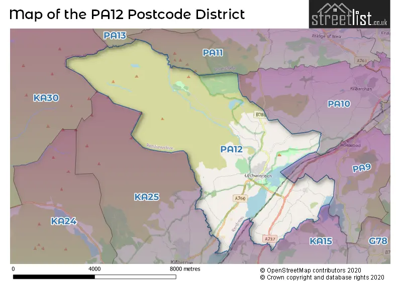
The PA12 Postcode shares a border with PA13 (KILMACOLM), KA30 (LARGS), KA25 (KILBIRNIE), PA9 (Howwood), PA10 (Kilbarchan), PA11 (BRIDGE OF WEIR, Quarrier's Village) and KA15 (BEITH, Barrmill, Burnhouse).
The primary settlement in the PA12 postcode district is Lochwinnoch, located in the county of Renfrewshire, Scotland. The most significant Postal Town in the district is Lochwinnoch.
For the district PA12, we have data on 1 postcode sectors. Here's a breakdown: The sector PA12 4, covers Lochwinnoch in Renfrewshire.
PA12 Postcode Sectors

Map of the PA12 Postcode District
Explore the PA12 postcode district by using our free interactive map.
When it comes to local government, postal geography often disregards political borders. However, for a breakdown in the PA12 District: the district mostly encompasses the Renfrewshire area with a total of 114 postcodes.
Where is the PA12 Postcode District?
The postcode district PA12 is located in Lochwinnoch. Lochwinnoch is surrounded by several nearby towns: Kilbirnie is located to the South and is approximately 3.66 miles away, Bridge of Weir is located to the Northeast and is approximately 4.15 miles away, Beith is located to the Southeast and is approximately 4.86 miles away, Kilmacolm is located to the North and is approximately 5.44 miles away, Kirkliston is located to the East and is approximately 6.12 miles away, Dalry is located to the Southwest and is approximately 6.28 miles away, and Largs is located to the West and is approximately 7.28 miles away. Additionally, Lochwinnoch is approximately 350.82 miles away from the center of London.
The district is within the post town of LOCHWINNOCH.
The sector has postcodes within the nation of Scotland.
The PA12 Postcode District is in the Inverclyde, East Renfrewshire and Renfrewshire region of West Central Scotland within the Scotland.
Weather Forecast for PA12
Press Button to Show Forecast for Lochwinnoch
| Time Period | Icon | Description | Temperature | Rain Probability | Wind |
|---|---|---|---|---|---|
| 06:00 to 09:00 | Cloudy | 16.0°C (feels like 16.0°C) | 8.00% | SE 2 mph | |
| 09:00 to 12:00 | Cloudy | 17.0°C (feels like 17.0°C) | 16.00% | E 4 mph | |
| 12:00 to 15:00 | Cloudy | 19.0°C (feels like 18.0°C) | 14.00% | E 4 mph | |
| 15:00 to 18:00 | Light rain shower (day) | 20.0°C (feels like 19.0°C) | 31.00% | SSW 7 mph | |
| 18:00 to 21:00 | Light rain shower (day) | 18.0°C (feels like 18.0°C) | 34.00% | SSE 4 mph | |
| 21:00 to 00:00 | Light rain shower (night) | 15.0°C (feels like 15.0°C) | 34.00% | SE 2 mph |
Press Button to Show Forecast for Lochwinnoch
| Time Period | Icon | Description | Temperature | Rain Probability | Wind |
|---|---|---|---|---|---|
| 00:00 to 03:00 | Light rain shower (night) | 14.0°C (feels like 14.0°C) | 31.00% | SE 2 mph | |
| 03:00 to 06:00 | Cloudy | 13.0°C (feels like 13.0°C) | 8.00% | NE 4 mph | |
| 06:00 to 09:00 | Cloudy | 13.0°C (feels like 13.0°C) | 7.00% | ENE 4 mph | |
| 09:00 to 12:00 | Cloudy | 16.0°C (feels like 15.0°C) | 7.00% | ENE 7 mph | |
| 12:00 to 15:00 | Light rain shower (day) | 18.0°C (feels like 17.0°C) | 33.00% | E 7 mph | |
| 15:00 to 18:00 | Cloudy | 18.0°C (feels like 17.0°C) | 33.00% | SE 7 mph | |
| 18:00 to 21:00 | Cloudy | 17.0°C (feels like 17.0°C) | 18.00% | SE 4 mph | |
| 21:00 to 00:00 | Cloudy | 15.0°C (feels like 14.0°C) | 15.00% | ENE 4 mph |
Press Button to Show Forecast for Lochwinnoch
| Time Period | Icon | Description | Temperature | Rain Probability | Wind |
|---|---|---|---|---|---|
| 00:00 to 03:00 | Cloudy | 14.0°C (feels like 13.0°C) | 19.00% | ENE 4 mph | |
| 03:00 to 06:00 | Light rain | 13.0°C (feels like 13.0°C) | 46.00% | ENE 4 mph | |
| 06:00 to 09:00 | Light rain | 13.0°C (feels like 13.0°C) | 46.00% | ENE 7 mph | |
| 09:00 to 12:00 | Light rain | 15.0°C (feels like 14.0°C) | 49.00% | ENE 7 mph | |
| 12:00 to 15:00 | Light rain shower (day) | 17.0°C (feels like 16.0°C) | 46.00% | E 9 mph | |
| 15:00 to 18:00 | Heavy rain shower (day) | 17.0°C (feels like 16.0°C) | 61.00% | ENE 9 mph | |
| 18:00 to 21:00 | Light rain shower (day) | 16.0°C (feels like 14.0°C) | 49.00% | E 11 mph | |
| 21:00 to 00:00 | Cloudy | 14.0°C (feels like 13.0°C) | 19.00% | ENE 9 mph |
Press Button to Show Forecast for Lochwinnoch
| Time Period | Icon | Description | Temperature | Rain Probability | Wind |
|---|---|---|---|---|---|
| 00:00 to 03:00 | Cloudy | 13.0°C (feels like 12.0°C) | 15.00% | ENE 7 mph | |
| 03:00 to 06:00 | Cloudy | 12.0°C (feels like 11.0°C) | 13.00% | ENE 7 mph | |
| 06:00 to 09:00 | Cloudy | 13.0°C (feels like 12.0°C) | 9.00% | ENE 7 mph | |
| 09:00 to 12:00 | Partly cloudy (day) | 15.0°C (feels like 15.0°C) | 5.00% | E 7 mph | |
| 12:00 to 15:00 | Partly cloudy (day) | 19.0°C (feels like 18.0°C) | 8.00% | ESE 7 mph | |
| 15:00 to 18:00 | Light rain shower (day) | 19.0°C (feels like 19.0°C) | 36.00% | SE 4 mph | |
| 18:00 to 21:00 | Light rain shower (day) | 18.0°C (feels like 18.0°C) | 35.00% | ESE 4 mph | |
| 21:00 to 00:00 | Partly cloudy (night) | 14.0°C (feels like 14.0°C) | 6.00% | E 4 mph |
Press Button to Show Forecast for Lochwinnoch
| Time Period | Icon | Description | Temperature | Rain Probability | Wind |
|---|---|---|---|---|---|
| 00:00 to 03:00 | Clear night | 12.0°C (feels like 11.0°C) | 4.00% | E 4 mph | |
| 03:00 to 06:00 | Cloudy | 11.0°C (feels like 10.0°C) | 6.00% | ENE 4 mph | |
| 06:00 to 09:00 | Cloudy | 12.0°C (feels like 11.0°C) | 8.00% | ENE 4 mph | |
| 09:00 to 12:00 | Cloudy | 15.0°C (feels like 14.0°C) | 8.00% | E 4 mph | |
| 12:00 to 15:00 | Cloudy | 18.0°C (feels like 17.0°C) | 11.00% | ENE 4 mph | |
| 15:00 to 18:00 | Cloudy | 19.0°C (feels like 18.0°C) | 14.00% | W 7 mph | |
| 18:00 to 21:00 | Cloudy | 18.0°C (feels like 17.0°C) | 11.00% | W 7 mph | |
| 21:00 to 00:00 | Partly cloudy (night) | 13.0°C (feels like 12.0°C) | 3.00% | WNW 7 mph |
Postcode Sectors within the PA12 District
| Postcode Sector | Delivery Office |
|---|---|
| PA12 4 | Johnstone Delivery Office |
| P | A | 1 | 2 | - | X | X | X |
| P | A | 1 | 2 | Space | Numeric | Letter | Letter |
Current Monthly Rental Prices
| # Bedrooms | Min Price | Max Price | Avg Price |
|---|---|---|---|
| 1 | £475 | £475 | £475 |
| 4 | £1,650 | £1,650 | £1,650 |
Current House Prices
| # Bedrooms | Min Price | Max Price | Avg Price |
|---|---|---|---|
| 1 | £139,999 | £139,999 | £139,999 |
| 2 | £150,000 | £425,000 | £287,500 |
| 3 | £260,000 | £260,000 | £260,000 |
| 4 | £320,000 | £320,000 | £320,000 |
Estate Agents who Operate in the PA12 District
| Logo | Name | Brand Name | Address | Contact Number | Total Properties |
|---|---|---|---|---|---|
 | Bridge Of Weir | Slater Hogg & Howison | 1 Windsor Place Windsor Place Main Street Bridge Of Weir PA11 3AF | 01505 801408 | 4 |
 | Glasgow | Ross & Liddell | 89 Byres Road Glasgow G11 5HN | 0141 673 1161 | 1 |
 | Paisley | Let It | 26 Causeyside Street, Paisley, PA1 1UN | 0141 673 7656 | 1 |
 | Glasgow | Robb Residential | The Beacon 176 St Vincent Street Glasgow G2 5SG | 0141 673 4582 | 1 |