The PH1 postcode district is a postal district located in the PH Perth postcode area with a population of 44,010 residents according to the 2011 Scotland Census.
The area of the PH1 postcode district is 129.17 square miles which is 334.54 square kilometres or 82,666.83 acres.
Currently, the PH1 district has about 1225 postcode units spread across 15 geographic postcode sectors.
Given that each sector allows for 400 unique postcode combinations, the district has a capacity of 6,000 postcodes. With 1225 postcodes already in use, this leaves 4775 units available.
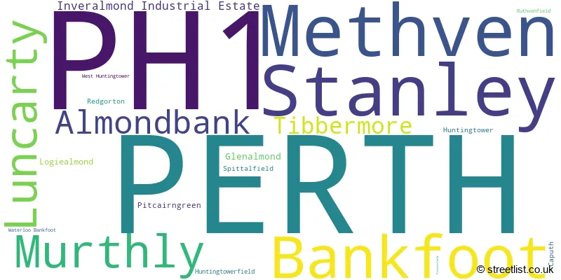
The largest settlement in the PH1 postal code is PERTH followed by Stanley, and Methven.
The postcode area has a boundary with The North Sea.
The PH1 Postcode shares a border with PH10 (BLAIRGOWRIE, Rattray, Bridge Of Cally), PH8 (DUNKELD, Birnam, Amulree), PH3 (AUCHTERARDER, Aberuthven, Gleneagles Village), PH7 (CRIEFF, Madderty, Gilmerton) and PH2 (PERTH, Scone, Bridge Of Earn).
In the PH1 postcode district in Perth and Kinross, the primary settlement is Perth, which has the highest count of 212. Other significant settlements include Tibbermore, Almondbank, Glenalmond, Huntingtower, Huntingtowerfield, Inveralmond Industrial Estate, Logiealmond, Luncarty, Methven, Pitcairngreen, Redgorton, Ruthvenfield, West Huntingtower, Bankfoot, Caputh, Murthly, Spittalfield, Stanley, and Waterloo Bankfoot. The post town for all these settlements is Perth. The PH1 postcode district is located in the county of Perth and Kinross in Scotland.
For the district PH1, we have data on 6 postcode sectors. Here's a breakdown: The sector PH1 0 is non-geographic. It's often designated for PO Boxes, large organisations, or special services. The sector PH1 1, covers Perth and Tibbermore in Perth and Kinross. The sector PH1 2, covers Perth in Perth and Kinross. The sector PH1 3, covers Perth and Methven and Luncarty and Almondbank in Perth and Kinross. The sector PH1 4, covers Stanley and Bankfoot and Murthly in Perth and Kinross. The sector PH1 5, covers Perth in Perth and Kinross.

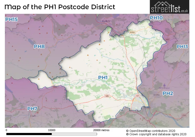
Map of the PH1 Postcode District
Explore the PH1 postcode district by using our free interactive map.
When it comes to local government, postal geography often disregards political borders. However, for a breakdown in the PH1 District: the district mostly encompasses the Perth and Kinross area with a total of 1242 postcodes.
Weather Forecast for PH1
Press Button to Show Forecast for Bankfoot
| Time Period | Icon | Description | Temperature | Rain Probability | Wind |
|---|---|---|---|---|---|
| 09:00 to 12:00 | Cloudy | 4.0°C (feels like 3.0°C) | 5.00% | NNW 4 mph | |
| 12:00 to 15:00 | Cloudy | 7.0°C (feels like 6.0°C) | 10.00% | S 4 mph | |
| 15:00 to 18:00 | Cloudy | 7.0°C (feels like 4.0°C) | 9.00% | S 9 mph | |
| 18:00 to 21:00 | Cloudy | 6.0°C (feels like 5.0°C) | 7.00% | E 4 mph | |
| 21:00 to 00:00 | Light rain | 5.0°C (feels like 3.0°C) | 47.00% | N 4 mph |
Press Button to Show Forecast for Bankfoot
| Time Period | Icon | Description | Temperature | Rain Probability | Wind |
|---|---|---|---|---|---|
| 00:00 to 03:00 | Cloudy | 4.0°C (feels like 3.0°C) | 13.00% | NE 2 mph | |
| 03:00 to 06:00 | Cloudy | 3.0°C (feels like 2.0°C) | 4.00% | NE 2 mph | |
| 06:00 to 09:00 | Cloudy | 4.0°C (feels like 3.0°C) | 4.00% | NNE 2 mph | |
| 09:00 to 12:00 | Cloudy | 7.0°C (feels like 6.0°C) | 7.00% | SE 2 mph | |
| 12:00 to 15:00 | Cloudy | 9.0°C (feels like 7.0°C) | 14.00% | SSE 7 mph | |
| 15:00 to 18:00 | Cloudy | 9.0°C (feels like 7.0°C) | 10.00% | SE 9 mph | |
| 18:00 to 21:00 | Cloudy | 8.0°C (feels like 5.0°C) | 5.00% | ESE 9 mph | |
| 21:00 to 00:00 | Partly cloudy (night) | 4.0°C (feels like 3.0°C) | 0.00% | ENE 4 mph |
Press Button to Show Forecast for Bankfoot
| Time Period | Icon | Description | Temperature | Rain Probability | Wind |
|---|---|---|---|---|---|
| 00:00 to 03:00 | Partly cloudy (night) | 3.0°C (feels like 1.0°C) | 0.00% | NE 4 mph | |
| 03:00 to 06:00 | Partly cloudy (night) | 2.0°C (feels like 0.0°C) | 1.00% | N 2 mph | |
| 06:00 to 09:00 | Partly cloudy (day) | 3.0°C (feels like 2.0°C) | 1.00% | NNW 2 mph | |
| 09:00 to 12:00 | Overcast | 8.0°C (feels like 6.0°C) | 8.00% | NNE 7 mph | |
| 12:00 to 15:00 | Cloudy | 10.0°C (feels like 9.0°C) | 7.00% | N 7 mph | |
| 15:00 to 18:00 | Cloudy | 11.0°C (feels like 9.0°C) | 6.00% | N 9 mph | |
| 18:00 to 21:00 | Cloudy | 10.0°C (feels like 9.0°C) | 6.00% | W 7 mph | |
| 21:00 to 00:00 | Clear night | 6.0°C (feels like 4.0°C) | 1.00% | W 4 mph |
Press Button to Show Forecast for Bankfoot
| Time Period | Icon | Description | Temperature | Rain Probability | Wind |
|---|---|---|---|---|---|
| 00:00 to 03:00 | Clear night | 4.0°C (feels like 2.0°C) | 1.00% | SSW 4 mph | |
| 03:00 to 06:00 | Partly cloudy (night) | 3.0°C (feels like 1.0°C) | 3.00% | SSW 4 mph | |
| 06:00 to 09:00 | Cloudy | 5.0°C (feels like 4.0°C) | 6.00% | SE 4 mph | |
| 09:00 to 12:00 | Cloudy | 9.0°C (feels like 8.0°C) | 14.00% | SSE 7 mph | |
| 12:00 to 15:00 | Light rain | 11.0°C (feels like 9.0°C) | 55.00% | S 11 mph | |
| 15:00 to 18:00 | Light rain shower (day) | 12.0°C (feels like 10.0°C) | 40.00% | S 11 mph | |
| 18:00 to 21:00 | Light rain shower (day) | 11.0°C (feels like 9.0°C) | 28.00% | SSE 9 mph | |
| 21:00 to 00:00 | Cloudy | 8.0°C (feels like 7.0°C) | 7.00% | SE 7 mph |
Press Button to Show Forecast for Bankfoot
| Time Period | Icon | Description | Temperature | Rain Probability | Wind |
|---|---|---|---|---|---|
| 00:00 to 03:00 | Cloudy | 7.0°C (feels like 5.0°C) | 8.00% | ESE 7 mph | |
| 03:00 to 06:00 | Cloudy | 7.0°C (feels like 5.0°C) | 7.00% | ESE 7 mph | |
| 06:00 to 09:00 | Cloudy | 8.0°C (feels like 6.0°C) | 9.00% | ESE 7 mph | |
| 09:00 to 12:00 | Partly cloudy (day) | 10.0°C (feels like 8.0°C) | 7.00% | ESE 9 mph | |
| 12:00 to 15:00 | Cloudy | 12.0°C (feels like 10.0°C) | 11.00% | ESE 11 mph | |
| 15:00 to 18:00 | Cloudy | 12.0°C (feels like 10.0°C) | 17.00% | E 11 mph | |
| 18:00 to 21:00 | Cloudy | 10.0°C (feels like 8.0°C) | 11.00% | E 11 mph | |
| 21:00 to 00:00 | Overcast | 8.0°C (feels like 6.0°C) | 19.00% | ENE 9 mph |
Where is the PH1 Postcode District?
The data shows that the postcode district of PH1 is located in the town of Perth, which is the district town. Perth is surrounded by several nearby towns, including Dunkeld to the North (7.89 miles away), Crieff to the South West (10.32 miles away), Blairgowrie to the North East (12.52 miles away), and Aberfeldy to the North West (17.28 miles away). Additionally, the distance from Perth to the center of London is 370.27 miles.
The district is within the post town of PERTH.
The sector has postcodes within the nation of Scotland.
The PH1 Postcode District is in the region of within the .
Postcode Sectors within the PH1 District
| Postcode Sector | Delivery Office |
|---|---|
| PH1 1 | Perth Delivery Office |
| PH1 2 | Perth Delivery Office |
| PH1 3 | Perth Delivery Office |
| PH1 4 | Perth Delivery Office |
| PH1 5 | Perth Delivery Office |
| P | H | 1 | - | X | X | X |
| P | H | 1 | Space | Numeric | Letter | Letter |
Current Monthly Rental Prices
| # Bedrooms | Min Price | Max Price | Avg Price |
|---|---|---|---|
| 1 | £425 | £661 | £512 |
| 2 | £675 | £800 | £738 |
| 3 | £795 | £950 | £873 |
Current House Prices
| # Bedrooms | Min Price | Max Price | Avg Price |
|---|---|---|---|
| £55,000 | £450,000 | £205,556 | |
| 1 | £45,000 | £129,500 | £84,491 |
| 2 | £35,000 | £245,000 | £131,423 |
| 3 | £109,950 | £485,000 | £236,649 |
| 4 | £250,000 | £585,000 | £342,623 |
| 5 | £265,000 | £569,000 | £437,438 |
| 6 | £525,000 | £1,200,000 | £916,667 |
| 7 | £550,000 | £550,000 | £550,000 |
| 8 | £1,025,000 | £1,025,000 | £1,025,000 |
| 9 | £1,200,000 | £1,200,000 | £1,200,000 |
| 10 | £400,000 | £1,195,000 | £797,500 |
| 12 | £600,000 | £600,000 | £600,000 |
Estate Agents who Operate in the PH1 District
| Logo | Name | Brand Name | Address | Contact Number | Total Properties |
|---|---|---|---|---|---|
 | Perth | Simple Approach Estate Agents | 13-15 St. Leonards Bridge, Perth, PH2 0DR | 01738 505880 | 22 |
 | Perth | Next Home | 63-65 George Street, Perth, PH1 5LB | 01738 505870 | 20 |
 | Perth | Premier Properties Perth | 45 King Street, Perth, PH2 8JB | 01738 505850 | 19 |
 | Perth | Possible Estate Agents | 6 Auld Bond Road, Perth PH1 3FX | 01738 503339 | 18 |
 | Perth | Aberdein Considine | 74 High Street, Perth PH1 5TH | 01738 505877 | 15 |