The PH2 postcode district is a postal district located in the PH Perth postcode area with a population of 34,632 residents according to the 2011 Scotland Census.
The area of the PH2 postcode district is 176.28 square miles which is 456.55 square kilometres or 112,816.69 acres.
Currently, the PH2 district has about 1257 postcode units spread across 12 geographic postcode sectors.
Given that each sector allows for 400 unique postcode combinations, the district has a capacity of 4,800 postcodes. With 1257 postcodes already in use, this leaves 3543 units available.
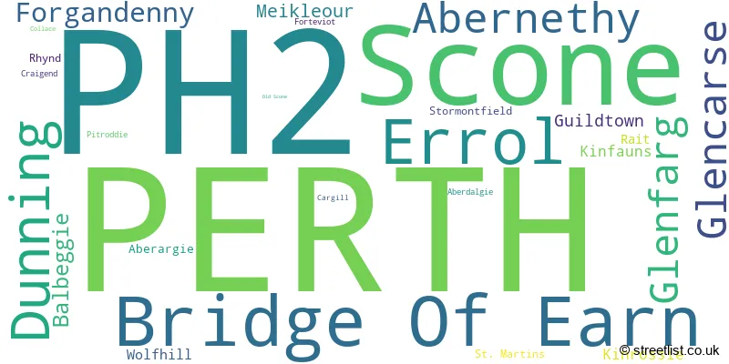
The largest settlement in the PH2 postal code is PERTH followed by Scone, and Bridge Of Earn.
The postcode area has a boundary with The North Sea.
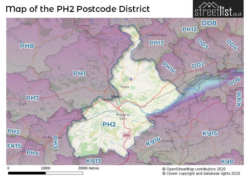
The PH2 Postcode shares a border with PH14 (Inchture, Abernyte), PH1 (PERTH, Stanley, Methven), PH10 (BLAIRGOWRIE, Rattray, Bridge Of Cally), KY13 (KINROSS, Milnathort, Crook Of Devon), PH13 (Coupar Angus, Burrelton, Kettins), PH3 (AUCHTERARDER, Aberuthven, Gleneagles Village), KY14 (Newburgh, Auchtermuchty, Strathmiglo) and FK14 (DOLLAR, Muckhart, Glendevon).
The primary settlement in the PH2 postcode district is Perth, located in the county of Perth and Kinross in Scotland. Other significant settlements in this district include Aberdalgie, Craigend, Dunning, Balbeggie, Cargill, Collace, Guildtown, Kinrossie, Meikleour, Old Scone, St. Martins, Stormontfield, and Wolfhill. The most significant post town in this district is Perth.
For the district PH2, we have data on 6 postcode sectors. Here's a breakdown: The sector PH2 0, covers Perth and Dunning in Perth and Kinross. The sector PH2 1 is non-geographic. It's often designated for PO Boxes, large organisations, or special services. The sector PH2 6, covers Scone in Perth and Kinross. The sector PH2 7, covers Perth and Errol and Glencarse in Perth and Kinross. The sector PH2 8, covers Perth in Perth and Kinross. The sector PH2 9, covers Bridge Of Earn and Abernethy and Glenfarg and Forgandenny in Perth and Kinross.

Map of the PH2 Postcode District
Explore the PH2 postcode district by using our free interactive map.
When it comes to local government, postal geography often disregards political borders. However, for a breakdown in the PH2 District: the district mostly encompasses the Perth and Kinross area with a total of 1264 postcodes.
Where is the PH2 Postcode District?
The data indicates that the postcode district of PH2 is located in the town of Perth. Perth is the district town for PH2. It is situated in close proximity to several nearby towns, including Auchterarder to the west, Kinross to the south, Glenrothes to the southeast, Cupar to the east, Blairgowrie to the north, and Dunkeld to the northwest. Furthermore, the distance between Perth and the center of London is approximately 361.95 miles.
The district is within the post town of PERTH.
The sector has postcodes within the nation of Scotland.
The PH2 Postcode District is in the region of within the .
Weather Forecast for PH2
Press Button to Show Forecast for Branklyn Gardens
| Time Period | Icon | Description | Temperature | Rain Probability | Wind |
|---|---|---|---|---|---|
| 12:00 to 15:00 | Cloudy | 15.0°C (feels like 14.0°C) | 4.00% | E 9 mph | |
| 15:00 to 18:00 | Cloudy | 15.0°C (feels like 13.0°C) | 6.00% | E 13 mph | |
| 18:00 to 21:00 | Cloudy | 14.0°C (feels like 13.0°C) | 6.00% | ENE 7 mph | |
| 21:00 to 00:00 | Cloudy | 13.0°C (feels like 12.0°C) | 51.00% | NE 4 mph |
Press Button to Show Forecast for Branklyn Gardens
| Time Period | Icon | Description | Temperature | Rain Probability | Wind |
|---|---|---|---|---|---|
| 00:00 to 03:00 | Light rain | 12.0°C (feels like 12.0°C) | 56.00% | NE 4 mph | |
| 03:00 to 06:00 | Cloudy | 11.0°C (feels like 10.0°C) | 50.00% | E 7 mph | |
| 06:00 to 09:00 | Cloudy | 12.0°C (feels like 11.0°C) | 19.00% | E 7 mph | |
| 09:00 to 12:00 | Light rain | 13.0°C (feels like 11.0°C) | 60.00% | E 13 mph | |
| 12:00 to 15:00 | Cloudy | 14.0°C (feels like 11.0°C) | 24.00% | E 13 mph | |
| 15:00 to 18:00 | Light rain | 14.0°C (feels like 12.0°C) | 64.00% | E 13 mph | |
| 18:00 to 21:00 | Overcast | 12.0°C (feels like 10.0°C) | 65.00% | E 13 mph | |
| 21:00 to 00:00 | Overcast | 12.0°C (feels like 10.0°C) | 19.00% | ENE 9 mph |
Press Button to Show Forecast for Branklyn Gardens
| Time Period | Icon | Description | Temperature | Rain Probability | Wind |
|---|---|---|---|---|---|
| 00:00 to 03:00 | Overcast | 11.0°C (feels like 10.0°C) | 22.00% | ENE 7 mph | |
| 03:00 to 06:00 | Overcast | 11.0°C (feels like 10.0°C) | 18.00% | ENE 4 mph | |
| 06:00 to 09:00 | Overcast | 12.0°C (feels like 11.0°C) | 13.00% | ENE 4 mph | |
| 09:00 to 12:00 | Partly cloudy (day) | 15.0°C (feels like 14.0°C) | 5.00% | E 4 mph | |
| 12:00 to 15:00 | Partly cloudy (day) | 17.0°C (feels like 16.0°C) | 3.00% | E 7 mph | |
| 15:00 to 18:00 | Sunny day | 17.0°C (feels like 16.0°C) | 4.00% | E 9 mph | |
| 18:00 to 21:00 | Cloudy | 14.0°C (feels like 13.0°C) | 6.00% | ENE 9 mph | |
| 21:00 to 00:00 | Partly cloudy (night) | 11.0°C (feels like 9.0°C) | 4.00% | ENE 7 mph |
Press Button to Show Forecast for Branklyn Gardens
| Time Period | Icon | Description | Temperature | Rain Probability | Wind |
|---|---|---|---|---|---|
| 00:00 to 03:00 | Overcast | 10.0°C (feels like 9.0°C) | 10.00% | NE 4 mph | |
| 03:00 to 06:00 | Mist | 9.0°C (feels like 8.0°C) | 15.00% | NE 4 mph | |
| 06:00 to 09:00 | Overcast | 10.0°C (feels like 10.0°C) | 11.00% | NE 4 mph | |
| 09:00 to 12:00 | Overcast | 13.0°C (feels like 13.0°C) | 9.00% | ENE 4 mph | |
| 12:00 to 15:00 | Partly cloudy (day) | 16.0°C (feels like 15.0°C) | 6.00% | E 7 mph | |
| 15:00 to 18:00 | Partly cloudy (day) | 17.0°C (feels like 16.0°C) | 5.00% | E 7 mph | |
| 18:00 to 21:00 | Sunny day | 15.0°C (feels like 14.0°C) | 6.00% | E 7 mph | |
| 21:00 to 00:00 | Clear night | 11.0°C (feels like 10.0°C) | 5.00% | E 4 mph |
Press Button to Show Forecast for Branklyn Gardens
| Time Period | Icon | Description | Temperature | Rain Probability | Wind |
|---|---|---|---|---|---|
| 00:00 to 03:00 | Clear night | 10.0°C (feels like 9.0°C) | 6.00% | NE 4 mph | |
| 03:00 to 06:00 | Partly cloudy (night) | 9.0°C (feels like 8.0°C) | 6.00% | NNW 4 mph | |
| 06:00 to 09:00 | Partly cloudy (day) | 11.0°C (feels like 10.0°C) | 7.00% | NNW 4 mph | |
| 09:00 to 12:00 | Partly cloudy (day) | 14.0°C (feels like 13.0°C) | 9.00% | NE 7 mph | |
| 12:00 to 15:00 | Sunny day | 16.0°C (feels like 15.0°C) | 13.00% | E 7 mph | |
| 15:00 to 18:00 | Cloudy | 16.0°C (feels like 15.0°C) | 15.00% | ENE 7 mph | |
| 18:00 to 21:00 | Sunny day | 14.0°C (feels like 13.0°C) | 13.00% | ENE 7 mph | |
| 21:00 to 00:00 | Clear night | 11.0°C (feels like 10.0°C) | 8.00% | ENE 4 mph |
Postcode Sectors within the PH2 District
| Postcode Sector | Delivery Office |
|---|---|
| PH2 0 | Perth Delivery Office |
| PH2 6 | Perth Delivery Office |
| PH2 7 | Perth Delivery Office |
| PH2 8 | Perth Delivery Office |
| PH2 9 | Perth Delivery Office |
| P | H | 2 | - | X | X | X |
| P | H | 2 | Space | Numeric | Letter | Letter |
Current Monthly Rental Prices
| # Bedrooms | Min Price | Max Price | Avg Price |
|---|---|---|---|
| 1 | £600 | £625 | £617 |
| 2 | £575 | £900 | £719 |
Current House Prices
| # Bedrooms | Min Price | Max Price | Avg Price |
|---|---|---|---|
| £70,000 | £650,000 | £195,625 | |
| 1 | £59,000 | £172,000 | £87,412 |
| 2 | £48,000 | £310,000 | £162,569 |
| 3 | £77,500 | £520,000 | £233,954 |
| 4 | £155,000 | £595,000 | £403,734 |
| 5 | £295,000 | £590,000 | £482,500 |
| 6 | £269,950 | £368,000 | £312,650 |
| 8 | £175,000 | £359,950 | £267,475 |
Estate Agents who Operate in the PH2 District
| Logo | Name | Brand Name | Address | Contact Number | Total Properties |
|---|---|---|---|---|---|
 | Perth | Possible Estate Agents | 6 Auld Bond Road, Perth PH1 3FX | 01738 503339 | 25 |
 | Perth | Simple Approach Estate Agents | 13-15 St. Leonards Bridge, Perth, PH2 0DR | 01738 505880 | 23 |
 | Perth | Clyde Property | 26 George Street, Perth, PH1 5JR | 01738 502914 | 16 |
 | Perth | Aberdein Considine | 74 High Street, Perth PH1 5TH | 01738 505877 | 15 |
 | Perth | Premier Properties Perth | 45 King Street, Perth, PH2 8JB | 01738 505850 | 15 |