The TR2 4 postcode sector is within the county of Cornwall.
Did you know? According to the 2021 Census, the TR2 4 postcode sector is home to a bustling 6,222 residents!
Given that each sector allows for 400 unique postcode combinations. Letters C, I, K, M, O and V are not allowed in the last two letters of a postcode. With 259 postcodes already in use, this leaves 141 units available.
The largest settlement in the TR2 4 postal code is Probus followed by Grampound Road, and Grampound.
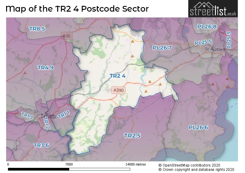
The TR2 4 Postcode shares a border with PL26 6 (Mevagissey, Gorran Haven, Duporth), PL26 7 (St. Stephen, Foxhole, Nanpean), TR1 1 (TRURO, Malpas, St. Clement), TR2 5 (Portscatho, St. Mawes, Tregony), TR4 9 (Goonhavern, Shortlanesend, St. Erme) and TR8 5 (Crantock, St. Newlyn East, Cubert).
The sector is within the post town of TRURO.
TR2 4 is a postcode sector within the TR2 postcode district which is within the PL Plymouth postcode area.
The Royal Mail delivery office for the TR2 4 postal sector is the Probus Scale Payment Delivery Office and Truro Delivery Office.
The area of the TR2 4 postcode sector is 35.23 square miles which is 91.24 square kilometres or 22,544.92 square acres.
Waterways within the TR2 4 postcode sector include the River Fal.

Map of the TR2 4 Postcode Sector
Explore the TR2 4 postcode sector by using our free interactive map.
| T | R | 2 | - | 4 | X | X |
| T | R | 2 | Space | 4 | Letter | Letter |
Official List of Streets
Probus (35 Streets)
Grampound Road (21 Streets)
Grampound (12 Streets)
Tresillian (15 Streets)
Ladock (5 Streets)
St. Michael Penkivel (1 Streets)
Unofficial Streets or Alternative Spellings
Grampound
TYBESTASt. Stephen
TERRAS ROADSchools and Places of Education Within the TR2 4 Postcode Sector
Grampound Road Village CofE School
Academy converter
South Street, Truro, Cornwall, TR2 4DY
Head: Miss Sarah Kennedy
Ofsted Rating: Good
Inspection: 2023-06-14 (344 days ago)
Website: Visit Grampound Road Village CofE School Website
Phone: 01726882646
Number of Pupils: 106
Ladock C of E School
Academy converter
Ladock, Truro, Cornwall, TR2 4PL
Head: Mr Thomas Hobbs
Ofsted Rating: Good
Inspection: 2019-02-13 (1926 days ago)
Website: Visit Ladock C of E School Website
Phone: 01726882622
Number of Pupils: 108
Probus Primary School
Academy converter
Ladock Road, Truro, Cornwall, TR2 4LE
Head: Mrs Angela Praed
Ofsted Rating: Good
Inspection: 2019-05-22 (1828 days ago)
Website: Visit Probus Primary School Website
Phone: 01726882647
Number of Pupils: 207
House Prices in the TR2 4 Postcode Sector
| Type of Property | 2018 Average | 2018 Sales | 2017 Average | 2017 Sales | 2016 Average | 2016 Sales | 2015 Average | 2015 Sales |
|---|---|---|---|---|---|---|---|---|
| Detached | £353,074 | 43 | £320,466 | 48 | £329,156 | 47 | £317,482 | 34 |
| Semi-Detached | £204,009 | 39 | £242,530 | 27 | £186,540 | 24 | £171,669 | 31 |
| Terraced | £191,064 | 43 | £180,273 | 38 | £180,139 | 36 | £169,684 | 24 |
| Flats | £147,800 | 5 | £150,483 | 3 | £92,500 | 1 | £146,000 | 2 |
Important Postcodes TR2 4 in the Postcode Sector
TR2 4EA is the postcode for Grampound Road School, South Street
TR2 4JZ is the postcode for The Surgery, Tregony Road
TR2 4LE is the postcode for Probus School, Ladock Road, Probus School, Ladock Road, Probus, and Probus Community Primary School, Ladock Road
TR2 4SB is the postcode for Grampound-With-Creed C of E School, Fore Street
| The TR2 4 Sector is within these Local Authorities |
|
|---|---|
| The TR2 4 Sector is within these Counties |
|
| The TR2 4 Sector is within these Water Company Areas |
|