The S35 4 postcode sector is within the county of South Yorkshire.
Did you know? According to the 2021 Census, the S35 4 postcode sector is home to a bustling 6,277 residents!
Given that each sector allows for 400 unique postcode combinations. Letters C, I, K, M, O and V are not allowed in the last two letters of a postcode. With 122 postcodes already in use, this leaves 278 units available.
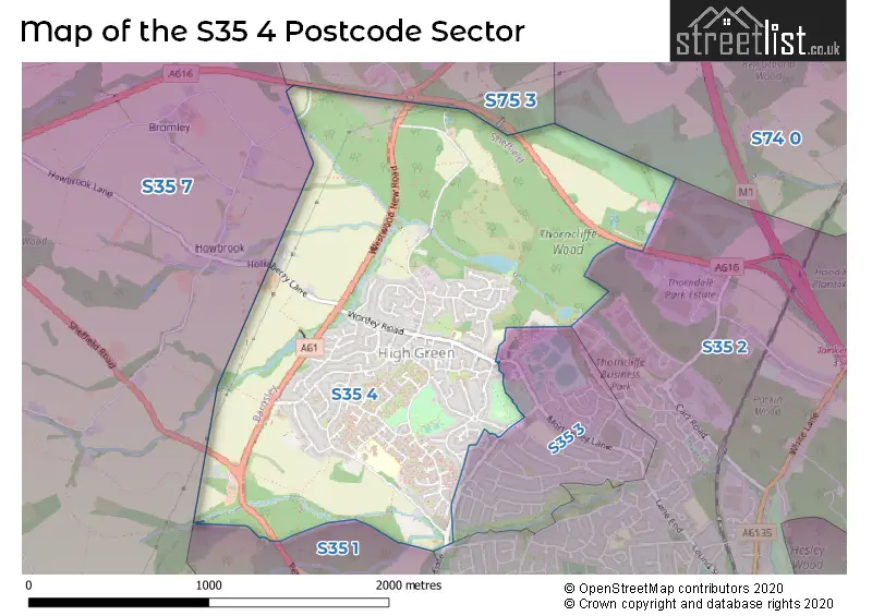
The S35 4 postal code covers the settlement of High Green.
The S35 4 Postcode shares a border with S35 3 (High Green, Chapeltown), S74 0 (Hoyland, Jump, Blacker Hill), S35 2 (Chapeltown), S35 1 (Chapeltown, Burncross), S35 7 (Thurgoland, Wortley, Crane Moor) and S75 3 (Dodworth, Tankersley, Hood Green).
The sector is within the post town of SHEFFIELD.
S35 4 is a postcode sector within the S35 postcode district which is within the S Sheffield postcode area.
The Royal Mail delivery office for the S35 4 postal sector is the Chapeltown Delivery Office.
The area of the S35 4 postcode sector is 1.53 square miles which is 3.97 square kilometres or 980.76 square acres.
The S35 4 postcode sector is crossed by the A616 Major A road.
Waterways within the S35 4 postcode sector include the Blackburn Brook.

Map of the S35 4 Postcode Sector
Explore the S35 4 postcode sector by using our free interactive map.
| S | 3 | 5 | - | 4 | X | X |
| S | 3 | 5 | Space | 4 | Letter | Letter |
Official List of Streets
High Green (94 Streets)
Unofficial Streets or Alternative Spellings
High Green
GREENGATE LANE MILES ROAD MORTOMLEY LANE BLACKBURN VALLEY TRAIL FARNABY ROAD HALLOW GATE KINSEY HEIGHTS PHILIP LANE SMITHY CLOSE STORRS LANE THOMPSON GARDENS TOMPSON HILL WARREN LANE WESTWOOD COURT WESTWOOD LANE WESTWOOD ROUNDABOUT WORTLEY COURTChapeltown
HOLLOW GATE NEWTON CHAMBERS ROAD PENISTONE ROAD STANLEY ROADTankersley
WESTWOOD NEW ROADWortley
HOLLINBERRY LANEWeather Forecast for S35 4
Press Button to Show Forecast for Chapeltown
| Time Period | Icon | Description | Temperature | Rain Probability | Wind |
|---|---|---|---|---|---|
| 15:00 to 18:00 | Cloudy | 22.0°C (feels like 20.0°C) | 3.00% | SE 9 mph | |
| 18:00 to 21:00 | Cloudy | 19.0°C (feels like 17.0°C) | 3.00% | ESE 11 mph | |
| 21:00 to 00:00 | Cloudy | 15.0°C (feels like 14.0°C) | 3.00% | ESE 7 mph |
Press Button to Show Forecast for Chapeltown
| Time Period | Icon | Description | Temperature | Rain Probability | Wind |
|---|---|---|---|---|---|
| 00:00 to 03:00 | Cloudy | 12.0°C (feels like 11.0°C) | 3.00% | ESE 4 mph | |
| 03:00 to 06:00 | Cloudy | 10.0°C (feels like 10.0°C) | 4.00% | ENE 2 mph | |
| 06:00 to 09:00 | Cloudy | 11.0°C (feels like 10.0°C) | 4.00% | NE 2 mph | |
| 09:00 to 12:00 | Cloudy | 15.0°C (feels like 14.0°C) | 3.00% | NE 4 mph | |
| 12:00 to 15:00 | Cloudy | 20.0°C (feels like 20.0°C) | 10.00% | E 7 mph | |
| 15:00 to 18:00 | Cloudy | 22.0°C (feels like 20.0°C) | 16.00% | SE 11 mph | |
| 18:00 to 21:00 | Cloudy | 20.0°C (feels like 19.0°C) | 12.00% | ESE 9 mph | |
| 21:00 to 00:00 | Cloudy | 16.0°C (feels like 16.0°C) | 13.00% | SE 4 mph |
Press Button to Show Forecast for Chapeltown
| Time Period | Icon | Description | Temperature | Rain Probability | Wind |
|---|---|---|---|---|---|
| 00:00 to 03:00 | Partly cloudy (night) | 14.0°C (feels like 14.0°C) | 5.00% | ESE 4 mph | |
| 03:00 to 06:00 | Partly cloudy (night) | 13.0°C (feels like 12.0°C) | 7.00% | SE 4 mph | |
| 06:00 to 09:00 | Partly cloudy (day) | 14.0°C (feels like 13.0°C) | 6.00% | S 7 mph | |
| 09:00 to 12:00 | Cloudy | 16.0°C (feels like 15.0°C) | 10.00% | S 9 mph | |
| 12:00 to 15:00 | Cloudy | 18.0°C (feels like 16.0°C) | 12.00% | S 13 mph | |
| 15:00 to 18:00 | Cloudy | 19.0°C (feels like 16.0°C) | 13.00% | SSE 13 mph | |
| 18:00 to 21:00 | Cloudy | 17.0°C (feels like 15.0°C) | 21.00% | SSE 11 mph | |
| 21:00 to 00:00 | Overcast | 15.0°C (feels like 13.0°C) | 27.00% | SE 11 mph |
Press Button to Show Forecast for Chapeltown
| Time Period | Icon | Description | Temperature | Rain Probability | Wind |
|---|---|---|---|---|---|
| 00:00 to 03:00 | Heavy rain | 14.0°C (feels like 12.0°C) | 78.00% | SE 11 mph | |
| 03:00 to 06:00 | Light rain | 13.0°C (feels like 12.0°C) | 55.00% | SE 9 mph | |
| 06:00 to 09:00 | Light rain | 13.0°C (feels like 12.0°C) | 55.00% | SSE 9 mph | |
| 09:00 to 12:00 | Heavy rain | 14.0°C (feels like 13.0°C) | 73.00% | SSE 9 mph | |
| 12:00 to 15:00 | Light rain shower (day) | 16.0°C (feels like 14.0°C) | 43.00% | SSE 11 mph | |
| 15:00 to 18:00 | Light rain shower (day) | 17.0°C (feels like 15.0°C) | 41.00% | SSE 11 mph | |
| 18:00 to 21:00 | Light rain shower (day) | 16.0°C (feels like 14.0°C) | 35.00% | SSE 11 mph | |
| 21:00 to 00:00 | Clear night | 14.0°C (feels like 12.0°C) | 7.00% | SSE 9 mph |
Press Button to Show Forecast for Chapeltown
| Time Period | Icon | Description | Temperature | Rain Probability | Wind |
|---|---|---|---|---|---|
| 00:00 to 03:00 | Partly cloudy (night) | 12.0°C (feels like 11.0°C) | 2.00% | SSE 9 mph | |
| 03:00 to 06:00 | Partly cloudy (night) | 11.0°C (feels like 10.0°C) | 3.00% | SSE 7 mph | |
| 06:00 to 09:00 | Cloudy | 12.0°C (feels like 10.0°C) | 7.00% | SSE 9 mph | |
| 09:00 to 12:00 | Cloudy | 14.0°C (feels like 12.0°C) | 11.00% | SSE 11 mph | |
| 12:00 to 15:00 | Partly cloudy (day) | 17.0°C (feels like 14.0°C) | 11.00% | SSE 11 mph | |
| 15:00 to 18:00 | Light rain shower (day) | 17.0°C (feels like 15.0°C) | 35.00% | SSE 11 mph | |
| 18:00 to 21:00 | Light rain shower (day) | 16.0°C (feels like 15.0°C) | 31.00% | S 9 mph | |
| 21:00 to 00:00 | Clear night | 14.0°C (feels like 13.0°C) | 4.00% | SSE 7 mph |
Schools and Places of Education Within the S35 4 Postcode Sector
Angram Bank Primary School
Community school
Kinsey Road, Sheffield, South Yorkshire, S35 4HN
Head: Andrea Carr
Ofsted Rating: Good
Inspection: 2021-09-22 (962 days ago)
Website: Visit Angram Bank Primary School Website
Phone: 01142848553
Number of Pupils: 216
High Green Primary School
Community school
Wortley Road, Sheffield, South Yorkshire, S35 4LU
Head: Mrs Diane Smales
Ofsted Rating: Good
Inspection: 2019-06-12 (1795 days ago)
Website: Visit High Green Primary School Website
Phone: 01142848264
Number of Pupils: 191
House Prices in the S35 4 Postcode Sector
| Type of Property | 2018 Average | 2018 Sales | 2017 Average | 2017 Sales | 2016 Average | 2016 Sales | 2015 Average | 2015 Sales |
|---|---|---|---|---|---|---|---|---|
| Detached | £190,684 | 17 | £218,668 | 23 | £196,977 | 28 | £183,670 | 22 |
| Semi-Detached | £132,225 | 26 | £139,884 | 29 | £134,577 | 26 | £120,353 | 22 |
| Terraced | £117,750 | 30 | £108,855 | 29 | £94,483 | 26 | £90,118 | 44 |
| Flats | £80,883 | 9 | £82,667 | 6 | £90,071 | 7 | £90,250 | 4 |
Important Postcodes S35 4 in the Postcode Sector
S35 4GX is the postcode for High Green Miners Welfare Community Hall, 47 Greno View Road
S35 4HN is the postcode for INFANT BUILDING, Angram Bank Primary School, Kinsey Road, Angram Bank Primary School, Kinsey Road, and JUNIOR BUILDING, Angram Bank Primary School, Kinsey Road
S35 4LU is the postcode for High Green Primary School, Wortley Road
S35 4NF is the postcode for High Green Health Centre, Thompson Hill
| The S35 4 Sector is within these Local Authorities |
|
|---|---|
| The S35 4 Sector is within these Counties |
|
| The S35 4 Sector is within these Water Company Areas |
|