The S9 4 postcode sector is within the county of South Yorkshire.
Did you know? According to the 2021 Census, the S9 4 postcode sector is home to a bustling 8,660 residents!
Given that each sector allows for 400 unique postcode combinations. Letters C, I, K, M, O and V are not allowed in the last two letters of a postcode. With 150 postcodes already in use, this leaves 250 units available.
The S9 4 postal code covers the settlement of SHEFFIELD.
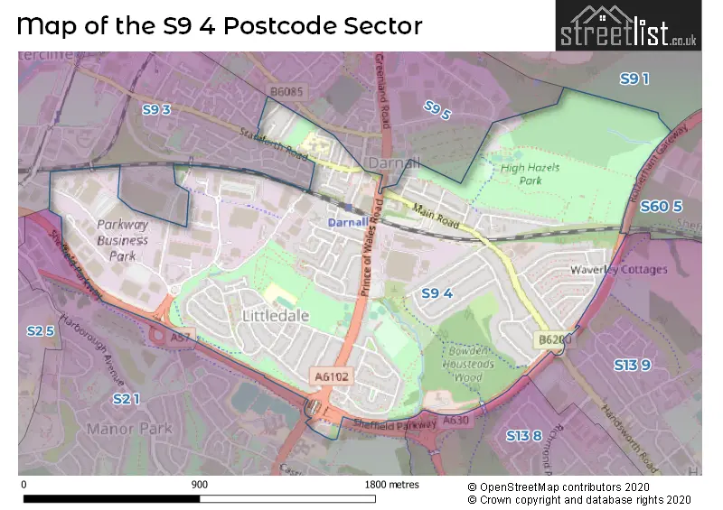
The S9 4 Postcode shares a border with S9 3 (SHEFFIELD), S2 1 (SHEFFIELD), S9 1 (SHEFFIELD, Tinsley), S13 8 (SHEFFIELD), S13 9 (SHEFFIELD, Handsworth, Woodhouse Mill), S60 5 (Brinsworth, Treeton, Catcliffe) and S9 5 (SHEFFIELD).
The sector is within the post town of SHEFFIELD.
S9 4 is a postcode sector within the S9 postcode district which is within the S Sheffield postcode area.
The Royal Mail delivery office for the S9 4 postal sector is the Sheffield Epostal Delivery Office.
The area of the S9 4 postcode sector is 1.22 square miles which is 3.17 square kilometres or 782.71 square acres.

Map of the S9 4 Postcode Sector
Explore the S9 4 postcode sector by using our free interactive map.
| S | 9 | - | 4 | X | X |
| S | 9 | Space | 4 | Letter | Letter |
Official List of Streets
SHEFFIELD (80 Streets)
Unofficial Streets or Alternative Spellings
SHEFFIELD
ACRES HILL ROAD CATLEY ROAD GREENLAND ROAD INFIELD LANE KETTLEBRIDGE ROAD SHEFFIELD PARKWAY SHIRLAND LANEHandsworth
HALL ROAD HANDSWORTH ROADWeather Forecast for S9 4
Press Button to Show Forecast for Darnall
| Time Period | Icon | Description | Temperature | Rain Probability | Wind |
|---|---|---|---|---|---|
| 12:00 to 15:00 | Overcast | 8.0°C (feels like 6.0°C) | 13.00% | NE 7 mph | |
| 15:00 to 18:00 | Cloudy | 9.0°C (feels like 7.0°C) | 8.00% | E 7 mph | |
| 18:00 to 21:00 | Cloudy | 8.0°C (feels like 5.0°C) | 9.00% | E 7 mph | |
| 21:00 to 00:00 | Cloudy | 7.0°C (feels like 4.0°C) | 5.00% | ENE 7 mph |
Press Button to Show Forecast for Darnall
| Time Period | Icon | Description | Temperature | Rain Probability | Wind |
|---|---|---|---|---|---|
| 00:00 to 03:00 | Cloudy | 5.0°C (feels like 4.0°C) | 4.00% | NE 4 mph | |
| 03:00 to 06:00 | Cloudy | 4.0°C (feels like 3.0°C) | 5.00% | NNE 4 mph | |
| 06:00 to 09:00 | Cloudy | 4.0°C (feels like 2.0°C) | 7.00% | NNE 4 mph | |
| 09:00 to 12:00 | Cloudy | 7.0°C (feels like 5.0°C) | 11.00% | NE 9 mph | |
| 12:00 to 15:00 | Overcast | 9.0°C (feels like 7.0°C) | 18.00% | ENE 9 mph | |
| 15:00 to 18:00 | Overcast | 9.0°C (feels like 7.0°C) | 20.00% | ENE 9 mph | |
| 18:00 to 21:00 | Cloudy | 8.0°C (feels like 6.0°C) | 14.00% | ENE 9 mph | |
| 21:00 to 00:00 | Cloudy | 7.0°C (feels like 4.0°C) | 8.00% | NE 9 mph |
Press Button to Show Forecast for Darnall
| Time Period | Icon | Description | Temperature | Rain Probability | Wind |
|---|---|---|---|---|---|
| 00:00 to 03:00 | Cloudy | 6.0°C (feels like 3.0°C) | 10.00% | N 9 mph | |
| 03:00 to 06:00 | Overcast | 6.0°C (feels like 2.0°C) | 25.00% | N 11 mph | |
| 06:00 to 09:00 | Light rain | 6.0°C (feels like 2.0°C) | 55.00% | N 11 mph | |
| 09:00 to 12:00 | Light rain | 7.0°C (feels like 3.0°C) | 56.00% | NNW 11 mph | |
| 12:00 to 15:00 | Light rain | 8.0°C (feels like 5.0°C) | 49.00% | NW 11 mph | |
| 15:00 to 18:00 | Cloudy | 10.0°C (feels like 8.0°C) | 15.00% | WNW 9 mph | |
| 18:00 to 21:00 | Sunny day | 10.0°C (feels like 8.0°C) | 6.00% | W 9 mph | |
| 21:00 to 00:00 | Clear night | 8.0°C (feels like 6.0°C) | 2.00% | SW 7 mph |
Press Button to Show Forecast for Darnall
| Time Period | Icon | Description | Temperature | Rain Probability | Wind |
|---|---|---|---|---|---|
| 00:00 to 03:00 | Clear night | 6.0°C (feels like 4.0°C) | 1.00% | SW 7 mph | |
| 03:00 to 06:00 | Clear night | 5.0°C (feels like 3.0°C) | 1.00% | SSW 7 mph | |
| 06:00 to 09:00 | Sunny day | 6.0°C (feels like 4.0°C) | 1.00% | S 7 mph | |
| 09:00 to 12:00 | Sunny day | 10.0°C (feels like 8.0°C) | 1.00% | S 11 mph | |
| 12:00 to 15:00 | Partly cloudy (day) | 13.0°C (feels like 11.0°C) | 3.00% | S 13 mph | |
| 15:00 to 18:00 | Cloudy | 14.0°C (feels like 12.0°C) | 6.00% | S 13 mph | |
| 18:00 to 21:00 | Partly cloudy (day) | 14.0°C (feels like 11.0°C) | 2.00% | SSE 11 mph | |
| 21:00 to 00:00 | Clear night | 11.0°C (feels like 9.0°C) | 2.00% | SSE 9 mph |
Press Button to Show Forecast for Darnall
| Time Period | Icon | Description | Temperature | Rain Probability | Wind |
|---|---|---|---|---|---|
| 00:00 to 03:00 | Clear night | 9.0°C (feels like 7.0°C) | 2.00% | SE 7 mph | |
| 03:00 to 06:00 | Clear night | 7.0°C (feels like 5.0°C) | 2.00% | SE 7 mph | |
| 06:00 to 09:00 | Sunny day | 8.0°C (feels like 6.0°C) | 3.00% | ESE 7 mph | |
| 09:00 to 12:00 | Cloudy | 11.0°C (feels like 10.0°C) | 7.00% | ESE 9 mph | |
| 12:00 to 15:00 | Partly cloudy (day) | 15.0°C (feels like 13.0°C) | 8.00% | ESE 11 mph | |
| 15:00 to 18:00 | Cloudy | 15.0°C (feels like 13.0°C) | 12.00% | ESE 11 mph | |
| 18:00 to 21:00 | Cloudy | 14.0°C (feels like 13.0°C) | 12.00% | ESE 9 mph | |
| 21:00 to 00:00 | Cloudy | 12.0°C (feels like 10.0°C) | 10.00% | E 7 mph |
Schools and Places of Education Within the S9 4 Postcode Sector
Acres Hill Community Primary School
Academy sponsor led
Mather Road, Sheffield, South Yorkshire, S9 4GQ
Head: Mr Christopher Howlett
Ofsted Rating: Good
Inspection: 2019-11-07 (1632 days ago)
Website: Visit Acres Hill Community Primary School Website
Phone: 01142441512
Number of Pupils: 225
High Hazels Junior School
Academy sponsor led
Fisher Lane, Sheffield, South Yorkshire, S9 4RP
Head: Miss Marie Elliott
Ofsted Rating: Good
Inspection: 2020-01-15 (1563 days ago)
Website: Visit High Hazels Junior School Website
Phone: 01142442189
Number of Pupils: 358
High Hazels Nursery Infant Academy
Academy sponsor led
Fisher Lane, Sheffield, South Yorkshire, S9 4RP
Head: Miss Marie Elliott
Ofsted Rating: Good
Inspection: 2023-05-11 (351 days ago)
Website: Visit High Hazels Nursery Infant Academy Website
Phone: 01142442189
Number of Pupils: 318
House Prices in the S9 4 Postcode Sector
| Type of Property | 2018 Average | 2018 Sales | 2017 Average | 2017 Sales | 2016 Average | 2016 Sales | 2015 Average | 2015 Sales |
|---|---|---|---|---|---|---|---|---|
| Detached | £118,252 | 2 | £0 | 0 | £130,250 | 2 | £124,250 | 2 |
| Semi-Detached | £110,803 | 61 | £105,625 | 90 | £104,902 | 73 | £100,759 | 85 |
| Terraced | £86,450 | 42 | £85,856 | 45 | £82,220 | 33 | £78,130 | 32 |
| Flats | £51,900 | 5 | £69,389 | 9 | £82,680 | 5 | £78,880 | 5 |
Important Postcodes S9 4 in the Postcode Sector
S9 4EP is the postcode for Parkway Fire Station, South Yorkshire Fire and Rescue Service, Reynolds Road
S9 4EU is the postcode for N H S Sheffield, 722 Prince of Wales Road
S9 4GQ is the postcode for Acres Hill Community Primary School, Mather Road, and Acres Hill Primary School, Mather Road
S9 4JT is the postcode for NEIGHBOURHOOD & COMMUNITY CARE SHEFFIELD COUNCIL OFFICES, City Wide Alarms, Sheffield Council Offices, Station Road
S9 4LR is the postcode for Leisure Services Building, 10 Acres Hill Lane
S9 4PE is the postcode for Tinsley Park Golf House, High Hazels Park
S9 4QH is the postcode for DARNALL PRIMARY CARE CENTRE, 290 MAIN ROAD, DARNALL, and Darnall Primary Care Centre, 290 Main Road
S9 4RA is the postcode for Darnall Childrens Centre, 563 Staniforth Road
S9 4RP is the postcode for High Hazels Academy, Fisher Lane, HIGH HAZELS ACADEMY, FISHER LANE, SHEFFIELD, and High Hazel Academy, Fisher Lane
S9 4WF is the postcode for Environment Agency, Quadrant 2, 99 Parkway Avenue
S9 4WG is the postcode for Parkway Business Centre, The Quadrant, 99 Parkway Avenue, and Parkway Business Centre, The Quadrant
| The S9 4 Sector is within these Local Authorities |
|
|---|---|
| The S9 4 Sector is within these Counties |
|
| The S9 4 Sector is within these Water Company Areas |
|