The SA11 3 postcode sector is within the county of West Glamorgan.
Did you know? According to the 2021 Census, the SA11 3 postcode sector is home to a bustling 11,181 residents!
Given that each sector allows for 400 unique postcode combinations. Letters C, I, K, M, O and V are not allowed in the last two letters of a postcode. With 272 postcodes already in use, this leaves 128 units available.
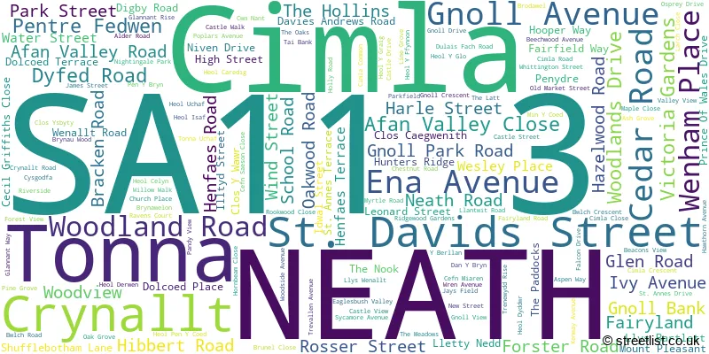
The largest settlement in the SA11 3 postal code is NEATH followed by TONNA, and CIMLA.
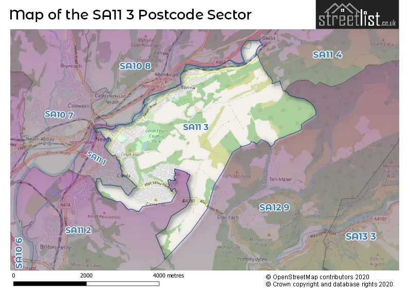
The SA11 3 Postcode shares a border with SA11 1 (NEATH, CIMLA), SA11 2 (NEATH, Briton Ferry, Penrhiwtyn), SA11 4 (RESOLVEN, CLYNE, Melincourt), SA12 9 (Cwmavon, PONTRHYDYFEN, TONMAWR) and SA10 8 (CRYNANT, CADOXTON, ABERDULAIS).
The sector is within the post town of NEATH.
SA11 3 is a postcode sector within the SA11 postcode district which is within the SA Swansea postcode area.
The Royal Mail delivery office for the SA11 3 postal sector is the Neath Delivery Office.
The area of the SA11 3 postcode sector is 5.57 square miles which is 14.42 square kilometres or 3,563.42 square acres.

Map of the SA11 3 Postcode Sector
Explore the SA11 3 postcode sector by using our free interactive map.
| S | A | 1 | 1 | - | 3 | X | X |
| S | A | 1 | 1 | Space | 3 | Letter | Letter |
Official List of Streets
NEATH (101 Streets)
Cimla (13 Streets)
Tonna (36 Streets)
Unofficial Streets or Alternative Spellings
Cimla
GREENWOOD DRIVE MACKWORTH DRIVENEATH
BRIDGE STREET BRYN ROAD CRESWELL ROAD CROFT ROAD EAGLESBUSH VALLEY FORSTER ROAD GOLWG Y DRE HILLSIDE RUGBY AVENUE WESTERNMOOR ROADWeather Forecast for SA11 3
Press Button to Show Forecast for Neath
| Time Period | Icon | Description | Temperature | Rain Probability | Wind |
|---|---|---|---|---|---|
| 03:00 to 06:00 | Overcast | 7.0°C (feels like 5.0°C) | 41.00% | ENE 9 mph | |
| 06:00 to 09:00 | Overcast | 7.0°C (feels like 4.0°C) | 14.00% | ENE 11 mph | |
| 09:00 to 12:00 | Cloudy | 8.0°C (feels like 5.0°C) | 8.00% | ENE 11 mph | |
| 12:00 to 15:00 | Overcast | 9.0°C (feels like 7.0°C) | 10.00% | ENE 11 mph | |
| 15:00 to 18:00 | Overcast | 11.0°C (feels like 8.0°C) | 10.00% | NE 11 mph | |
| 18:00 to 21:00 | Cloudy | 10.0°C (feels like 8.0°C) | 6.00% | NE 11 mph | |
| 21:00 to 00:00 | Cloudy | 9.0°C (feels like 6.0°C) | 6.00% | NNE 9 mph |
Press Button to Show Forecast for Neath
| Time Period | Icon | Description | Temperature | Rain Probability | Wind |
|---|---|---|---|---|---|
| 00:00 to 03:00 | Cloudy | 8.0°C (feels like 5.0°C) | 6.00% | NNE 11 mph | |
| 03:00 to 06:00 | Cloudy | 7.0°C (feels like 4.0°C) | 9.00% | N 9 mph | |
| 06:00 to 09:00 | Cloudy | 7.0°C (feels like 4.0°C) | 10.00% | N 9 mph | |
| 09:00 to 12:00 | Partly cloudy (day) | 10.0°C (feels like 7.0°C) | 6.00% | NNW 11 mph | |
| 12:00 to 15:00 | Cloudy | 12.0°C (feels like 9.0°C) | 7.00% | NW 11 mph | |
| 15:00 to 18:00 | Cloudy | 12.0°C (feels like 9.0°C) | 10.00% | WNW 13 mph | |
| 18:00 to 21:00 | Sunny day | 11.0°C (feels like 9.0°C) | 1.00% | W 11 mph | |
| 21:00 to 00:00 | Clear night | 9.0°C (feels like 7.0°C) | 2.00% | WSW 9 mph |
Press Button to Show Forecast for Neath
| Time Period | Icon | Description | Temperature | Rain Probability | Wind |
|---|---|---|---|---|---|
| 00:00 to 03:00 | Cloudy | 9.0°C (feels like 7.0°C) | 5.00% | SSW 9 mph | |
| 03:00 to 06:00 | Cloudy | 9.0°C (feels like 6.0°C) | 6.00% | S 11 mph | |
| 06:00 to 09:00 | Cloudy | 9.0°C (feels like 7.0°C) | 6.00% | SSE 11 mph | |
| 09:00 to 12:00 | Cloudy | 11.0°C (feels like 8.0°C) | 10.00% | SSE 16 mph | |
| 12:00 to 15:00 | Cloudy | 13.0°C (feels like 10.0°C) | 14.00% | S 16 mph | |
| 15:00 to 18:00 | Cloudy | 13.0°C (feels like 10.0°C) | 20.00% | S 16 mph | |
| 18:00 to 21:00 | Light rain shower (day) | 12.0°C (feels like 9.0°C) | 41.00% | SSE 16 mph | |
| 21:00 to 00:00 | Cloudy | 11.0°C (feels like 8.0°C) | 15.00% | SE 16 mph |
Press Button to Show Forecast for Neath
| Time Period | Icon | Description | Temperature | Rain Probability | Wind |
|---|---|---|---|---|---|
| 00:00 to 03:00 | Cloudy | 11.0°C (feels like 8.0°C) | 17.00% | SE 16 mph | |
| 03:00 to 06:00 | Cloudy | 10.0°C (feels like 7.0°C) | 16.00% | SE 16 mph | |
| 06:00 to 09:00 | Cloudy | 10.0°C (feels like 7.0°C) | 16.00% | SE 16 mph | |
| 09:00 to 12:00 | Cloudy | 12.0°C (feels like 9.0°C) | 19.00% | SE 16 mph | |
| 12:00 to 15:00 | Cloudy | 13.0°C (feels like 10.0°C) | 16.00% | SE 16 mph | |
| 15:00 to 18:00 | Cloudy | 14.0°C (feels like 11.0°C) | 18.00% | SE 13 mph | |
| 18:00 to 21:00 | Cloudy | 13.0°C (feels like 11.0°C) | 11.00% | SE 11 mph | |
| 21:00 to 00:00 | Cloudy | 12.0°C (feels like 10.0°C) | 10.00% | ESE 9 mph |
House Prices in the SA11 3 Postcode Sector
| Type of Property | 2018 Average | 2018 Sales | 2017 Average | 2017 Sales | 2016 Average | 2016 Sales | 2015 Average | 2015 Sales |
|---|---|---|---|---|---|---|---|---|
| Detached | £219,601 | 71 | £194,102 | 38 | £188,034 | 29 | £178,244 | 43 |
| Semi-Detached | £145,364 | 84 | £128,483 | 71 | £124,750 | 71 | £120,210 | 59 |
| Terraced | £113,867 | 42 | £118,001 | 42 | £106,255 | 31 | £108,479 | 40 |
| Flats | £63,561 | 8 | £56,000 | 2 | £56,800 | 5 | £54,595 | 5 |
Important Postcodes SA11 3 in the Postcode Sector
SA11 3AA is the postcode for Alderman Davies Church in Wales Primary School, St. Davids Street, and Alderman Davies Church In Wales Primary School, St Davids Street
SA11 3AH is the postcode for The Hafod, Wenham Place
SA11 3AL is the postcode for Ysgol Gynradd Gymraeg Castell Nedd, Woodland Road, and UNIT 2, Ysgol Cymreag Castell Nedd, Woodland Road
SA11 3AN is the postcode for Neath Health Centre, Dyfed Road
SA11 3AW is the postcode for Neath Leisure Centre, Dyfed Road
SA11 3AZ is the postcode for CRYNALLT INFANT SCHOOL, AFAN VALLEY ROAD, CIMLA, Crynallt Infant School, Afan Valley Road, CRYNALLT JUNIOR SCHOOL, AFAN VALLEY ROAD, CIMLA, and Crynallt Junior School, Afan Valley Road
SA11 3BA is the postcode for Neath Port Talbot County Borough Council, Neath Library, Victoria Gardens
SA11 3BG is the postcode for South Wales Constabulary, Neath Police Station, Gnoll Park Road
SA11 3BN is the postcode for Neath Port Talbot Register Office, Forster Road
SA11 3BS is the postcode for Neath Port Talbot County Borough Council, Visitor Centre Gnoll Estate
SA11 3BW is the postcode for Neath Police Station, Gnoll Park Road
SA11 3EJ is the postcode for INFANT BLOCK, Tonnau Primary Community School, School Road, and Tonnau Primary Community School, School Road
SA11 3EP is the postcode for Neath Wellness Centre, Water Street
SA11 3LX is the postcode for Bromorganning N H S Trust, Tonna Hospital, Tonna Uchaf, Tonna Hospital, Tonna Uchaf, RESOURCE CENTRE, Tonna Hospital, Tonna Uchaf, TONNA HOSPITAL, TONNA UCHAF, TONNA, and Bro Morgannwg N H S Trust, Tonna Hospital
SA11 3QZ is the postcode for Neath Port Talbot County Borough Council, Civic Centre,, and Neath Civic Centre, Water Street
SA11 3SU is the postcode for Cimla Hospital, Cimla Common
SA11 3TA is the postcode for Cefn Saeson Comprehensive School, Afan Valley Road
SA11 3UG is the postcode for Neath Fire Station, Cimla Road
| The SA11 3 Sector is within these Local Authorities |
|
|---|---|
| The SA11 3 Sector is within these Counties |
|
| The SA11 3 Sector is within these Water Company Areas |
|