The SA10 8 postcode sector stands on the Powys and West Glamorgan border.
Did you know? According to the 2021 Census, the SA10 8 postcode sector is home to a bustling 6,476 residents!
Given that each sector allows for 400 unique postcode combinations. Letters C, I, K, M, O and V are not allowed in the last two letters of a postcode. With 166 postcodes already in use, this leaves 234 units available.
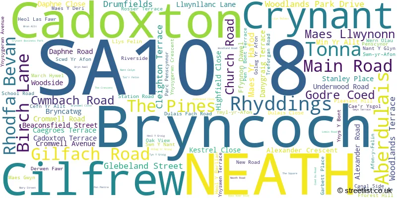
The largest settlement in the SA10 8 postal code is CRYNANT followed by CADOXTON, and ABERDULAIS.
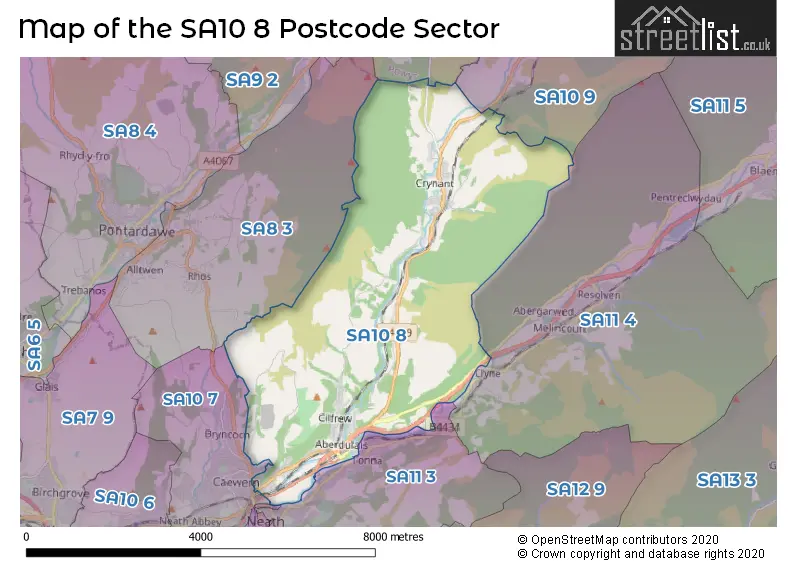
The SA10 8 Postcode shares a border with SA8 3 (PONTARDAWE, ALLTWEN, RHOS), SA9 1 (YSTRADGYNLAIS, LOWER CWMTWRCH, PENYCAE), SA11 1 (NEATH, CIMLA), SA11 3 (NEATH, TONNA, CIMLA), SA11 4 (RESOLVEN, CLYNE, Melincourt), SA10 7 (NEATH, Bryncoch, Neath Abbey) and SA10 9 (SEVEN SISTERS, COELBREN, DYFFRYN CELLWEN).
The sector is within the post town of NEATH.
SA10 8 is a postcode sector within the SA10 postcode district which is within the SA Swansea postcode area.
The Royal Mail delivery office for the SA10 8 postal sector is the Neath Delivery Office.
The area of the SA10 8 postcode sector is 14.80 square miles which is 38.34 square kilometres or 9,474.75 square acres.

Map of the SA10 8 Postcode Sector
Explore the SA10 8 postcode sector by using our free interactive map.
| S | A | 1 | 0 | - | 8 | X | X |
| S | A | 1 | 0 | Space | 8 | Letter | Letter |
Official List of Streets
Crynant (32 Streets)
NEATH (11 Streets)
Rhyddings (1 Streets)
Cadoxton (18 Streets)
Cilfrew (15 Streets)
Aberdulais (16 Streets)
Bryncoch (2 Streets)
Tonna (1 Streets)
Unofficial Streets or Alternative Spellings
Seven Sisters
DULAIS ROADCrynant
S?N Y NANT BEACONSFIELD ROAD BEVAN AVENUE BRYN CATWG BRYNAWEL CEFN-YR-ALLT GER-YR-AFON GOLWG Y CRAIG GOLWG-Y-GAMLAS GOLWG-YR-AFON HEOL BERLLAN HEOL Y CRAIG L�N BEDW MAES-Y-DERI MAES-YR-HAFOD PARC PENSCYNOR PEN-Y-WERN ROAD PENSCYNOR LANE SARN HELEN SCWD-YR-AFON SWN-Y-NANTAberdulais
AFON-Y-FELIN SWN-YR-AFON YMYL-YR-AFONNEATH
CADOXTON ROAD PENYWERN ROADBryncoch
HERONS WAYWeather Forecast for SA10 8
Press Button to Show Forecast for Pontardawe
| Time Period | Icon | Description | Temperature | Rain Probability | Wind |
|---|---|---|---|---|---|
| 06:00 to 09:00 | Cloudy | 6.0°C (feels like 4.0°C) | 6.00% | ENE 7 mph | |
| 09:00 to 12:00 | Cloudy | 8.0°C (feels like 6.0°C) | 11.00% | E 11 mph | |
| 12:00 to 15:00 | Cloudy | 10.0°C (feels like 8.0°C) | 9.00% | ESE 9 mph | |
| 15:00 to 18:00 | Cloudy | 10.0°C (feels like 9.0°C) | 11.00% | ESE 9 mph | |
| 18:00 to 21:00 | Cloudy | 10.0°C (feels like 9.0°C) | 13.00% | E 7 mph | |
| 21:00 to 00:00 | Cloudy | 9.0°C (feels like 7.0°C) | 11.00% | ENE 9 mph |
Press Button to Show Forecast for Pontardawe
| Time Period | Icon | Description | Temperature | Rain Probability | Wind |
|---|---|---|---|---|---|
| 00:00 to 03:00 | Cloudy | 8.0°C (feels like 5.0°C) | 13.00% | ENE 9 mph | |
| 03:00 to 06:00 | Cloudy | 7.0°C (feels like 4.0°C) | 10.00% | ENE 11 mph | |
| 06:00 to 09:00 | Cloudy | 7.0°C (feels like 4.0°C) | 8.00% | ENE 11 mph | |
| 09:00 to 12:00 | Cloudy | 9.0°C (feels like 6.0°C) | 7.00% | ENE 13 mph | |
| 12:00 to 15:00 | Overcast | 11.0°C (feels like 8.0°C) | 14.00% | ENE 11 mph | |
| 15:00 to 18:00 | Overcast | 11.0°C (feels like 9.0°C) | 17.00% | ENE 11 mph | |
| 18:00 to 21:00 | Cloudy | 11.0°C (feels like 9.0°C) | 12.00% | NE 11 mph | |
| 21:00 to 00:00 | Overcast | 9.0°C (feels like 7.0°C) | 20.00% | NNE 11 mph |
Press Button to Show Forecast for Pontardawe
| Time Period | Icon | Description | Temperature | Rain Probability | Wind |
|---|---|---|---|---|---|
| 00:00 to 03:00 | Cloudy | 9.0°C (feels like 6.0°C) | 16.00% | NNE 11 mph | |
| 03:00 to 06:00 | Light rain | 8.0°C (feels like 5.0°C) | 47.00% | N 11 mph | |
| 06:00 to 09:00 | Light rain | 7.0°C (feels like 4.0°C) | 48.00% | N 11 mph | |
| 09:00 to 12:00 | Light rain shower (day) | 9.0°C (feels like 6.0°C) | 40.00% | N 13 mph | |
| 12:00 to 15:00 | Cloudy | 11.0°C (feels like 8.0°C) | 19.00% | NNW 13 mph | |
| 15:00 to 18:00 | Cloudy | 12.0°C (feels like 9.0°C) | 17.00% | NNW 13 mph | |
| 18:00 to 21:00 | Sunny day | 11.0°C (feels like 8.0°C) | 8.00% | NW 11 mph | |
| 21:00 to 00:00 | Clear night | 9.0°C (feels like 7.0°C) | 5.00% | NW 9 mph |
House Prices in the SA10 8 Postcode Sector
| Type of Property | 2018 Average | 2018 Sales | 2017 Average | 2017 Sales | 2016 Average | 2016 Sales | 2015 Average | 2015 Sales |
|---|---|---|---|---|---|---|---|---|
| Detached | £223,967 | 32 | £207,532 | 31 | £234,882 | 38 | £179,498 | 33 |
| Semi-Detached | £117,395 | 41 | £107,898 | 40 | £118,279 | 38 | £108,858 | 41 |
| Terraced | £84,047 | 21 | £94,476 | 21 | £105,925 | 10 | £86,103 | 17 |
| Flats | £0 | 0 | £45,000 | 1 | £50,667 | 3 | £48,000 | 1 |
Important Postcodes SA10 8 in the Postcode Sector
SA10 8BL is the postcode for Catwg Primary School, Main Road, and Catwg Primary School, Main Road, Cadoxton
SA10 8DB is the postcode for MAIN BLOCK, Llangatwg Comprehensive School, Main Road, UNIT 2 SCIENCE BLOCK, Llangatwg Comprehensive School, Main Road, OLD BLOCK, Llangatwg Comprehensive School, Main Road, UNIT 7 YOUTH BLOCK, Llangatwg Comprehensive School, Main Road, UNIT 4 WELSH BLOCK, Llangatwg Comprehensive School, Main Road, UNIT 3 TECHNOLOGY BLOCK, Llangatwg Comprehensive School, Main Road, UNIT 6 GYM BLOCK, Llangatwg Comprehensive School, Main Road, and CANTEEN BLOCK, Llangatwg Comprehensive School, Main Road
SA10 8LF is the postcode for Cilffriw Primary School, Penscynor, Cilfrew, and Cilffriw Primary School, Penscynor
SA10 8SN is the postcode for Cefn Coed Colliery Museum, Neath Road
| The SA10 8 Sector is within these Local Authorities |
|
|---|---|
| The SA10 8 Sector is within these Counties |
|
| The SA10 8 Sector is within these Water Company Areas |
|
Tourist Attractions within the SA10 8 Postcode Area
We found 1 visitor attractions within the SA10 postcode area
| Aberdulais Falls |
|---|
| View Aberdulais Falls on Google Maps |