The SA32 7 postcode sector is within the county of Dyfed.
Did you know? According to the 2021 Census, the SA32 7 postcode sector is home to a bustling 3,929 residents!
Given that each sector allows for 400 unique postcode combinations. Letters C, I, K, M, O and V are not allowed in the last two letters of a postcode. With 217 postcodes already in use, this leaves 183 units available.
The largest settlement in the SA32 7 postal code is NANTGAREDIG followed by PENIEL, and LLANFYNYDD.
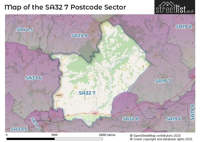
The SA32 7 Postcode shares a border with SA33 6 (CYNWYL ELFED, BRONWYDD, LLANPUMSAINT), SA19 7 (TALLEY, LLANSAWEL, LLANDEILO), SA31 2 (LLANGUNNOR, CARMARTHEN, ABERGWILI), SA32 8 (LLANARTHNE, DRYSLWYN, PORTHYRHYD), SA39 9 (PENCADER, MAESYCRUGIAU, LLANFIHANGEL-AR-ARTH) and SA40 9 (LLANYBYDDER, CWRTNEWYDD, GORSGOCH).
The sector is within the post town of CARMARTHEN.
SA32 7 is a postcode sector within the SA3 postcode district which is within the SA Swansea postcode area.
The Royal Mail delivery office for the SA32 7 postal sector is the unknown.
The area of the SA32 7 postcode sector is 78.22 square miles which is 202.59 square kilometres or 50,060.06 square acres.


Map of the SA32 7 Postcode Sector
Explore the SA32 7 postcode sector by using our free interactive map.
| S | A | 3 | 2 | - | 7 | X | X |
| S | A | 3 | 2 | Space | 7 | Letter | Letter |
Official List of Streets
CARMARTHEN (5 Streets)
Felingwm (1 Streets)
Alltwalis (2 Streets)
Nantgaredig (6 Streets)
Llanfynydd (1 Streets)
Peniel (9 Streets)
Rhydargaeau (4 Streets)
Pontargothi (2 Streets)
Unofficial Streets or Alternative Spellings
Abergwili
CASTELL PIGYN ROADGlangwili
DOLGWILI ROADAlltwalis
DANYBRYNWeather Forecast for SA32 7
Press Button to Show Forecast for New Inn
| Time Period | Icon | Description | Temperature | Rain Probability | Wind |
|---|---|---|---|---|---|
| 18:00 to 21:00 | Heavy rain | 9.0°C (feels like 6.0°C) | 93.00% | SSW 16 mph | |
| 21:00 to 00:00 | Heavy rain | 9.0°C (feels like 6.0°C) | 89.00% | S 13 mph |
Press Button to Show Forecast for New Inn
| Time Period | Icon | Description | Temperature | Rain Probability | Wind |
|---|---|---|---|---|---|
| 00:00 to 03:00 | Heavy rain | 9.0°C (feels like 5.0°C) | 91.00% | SSE 18 mph | |
| 03:00 to 06:00 | Heavy rain | 9.0°C (feels like 5.0°C) | 90.00% | SSE 18 mph | |
| 06:00 to 09:00 | Heavy rain | 9.0°C (feels like 5.0°C) | 91.00% | SE 20 mph | |
| 09:00 to 12:00 | Heavy rain | 9.0°C (feels like 5.0°C) | 91.00% | SSE 20 mph | |
| 12:00 to 15:00 | Heavy rain | 9.0°C (feels like 6.0°C) | 89.00% | S 13 mph | |
| 15:00 to 18:00 | Heavy rain | 9.0°C (feels like 7.0°C) | 78.00% | S 11 mph | |
| 18:00 to 21:00 | Light rain shower (day) | 9.0°C (feels like 7.0°C) | 43.00% | S 9 mph | |
| 21:00 to 00:00 | Cloudy | 7.0°C (feels like 5.0°C) | 11.00% | SSE 7 mph |
Press Button to Show Forecast for New Inn
| Time Period | Icon | Description | Temperature | Rain Probability | Wind |
|---|---|---|---|---|---|
| 00:00 to 03:00 | Clear night | 6.0°C (feels like 4.0°C) | 4.00% | SSE 7 mph | |
| 03:00 to 06:00 | Partly cloudy (night) | 5.0°C (feels like 3.0°C) | 2.00% | SE 7 mph | |
| 06:00 to 09:00 | Partly cloudy (day) | 6.0°C (feels like 4.0°C) | 2.00% | ESE 7 mph | |
| 09:00 to 12:00 | Cloudy | 10.0°C (feels like 8.0°C) | 8.00% | SE 9 mph | |
| 12:00 to 15:00 | Cloudy | 12.0°C (feels like 10.0°C) | 8.00% | SSE 9 mph | |
| 15:00 to 18:00 | Cloudy | 12.0°C (feels like 11.0°C) | 10.00% | SE 7 mph | |
| 18:00 to 21:00 | Cloudy | 10.0°C (feels like 10.0°C) | 16.00% | WSW 4 mph | |
| 21:00 to 00:00 | Cloudy | 8.0°C (feels like 7.0°C) | 15.00% | N 4 mph |
Press Button to Show Forecast for New Inn
| Time Period | Icon | Description | Temperature | Rain Probability | Wind |
|---|---|---|---|---|---|
| 00:00 to 03:00 | Light rain | 8.0°C (feels like 7.0°C) | 48.00% | NNW 4 mph | |
| 03:00 to 06:00 | Cloudy | 8.0°C (feels like 6.0°C) | 17.00% | NNW 7 mph | |
| 06:00 to 09:00 | Light rain | 8.0°C (feels like 6.0°C) | 46.00% | NNW 9 mph | |
| 09:00 to 12:00 | Light rain | 10.0°C (feels like 8.0°C) | 45.00% | NNW 9 mph | |
| 12:00 to 15:00 | Cloudy | 13.0°C (feels like 11.0°C) | 9.00% | NNW 9 mph | |
| 15:00 to 18:00 | Cloudy | 14.0°C (feels like 12.0°C) | 15.00% | NNW 9 mph | |
| 18:00 to 21:00 | Partly cloudy (day) | 13.0°C (feels like 11.0°C) | 4.00% | NNW 9 mph | |
| 21:00 to 00:00 | Clear night | 9.0°C (feels like 8.0°C) | 5.00% | NW 7 mph |
House Prices in the SA32 7 Postcode Sector
| Type of Property | 2018 Average | 2018 Sales | 2017 Average | 2017 Sales | 2016 Average | 2016 Sales | 2015 Average | 2015 Sales |
|---|---|---|---|---|---|---|---|---|
| Detached | £257,934 | 51 | £250,572 | 31 | £251,543 | 31 | £201,476 | 41 |
| Semi-Detached | £215,000 | 6 | £120,000 | 7 | £118,000 | 5 | £148,083 | 6 |
| Terraced | £90,000 | 1 | £87,500 | 1 | £195,333 | 3 | £140,000 | 2 |
| Flats | £78,000 | 1 | £0 | 0 | £0 | 0 | £70,500 | 1 |
Important Postcodes SA32 7 in the Postcode Sector
SA32 7AB is the postcode for Peniel Cp School, C2048 From, Peniel, and Ysgol Gynradd Peniel, Peniel
SA32 7LG is the postcode for Meddygfa Tywi, Station Road, Ysgol Nantgaredig, Station Road, and Nantgaredig C P School, Station Road
| The SA32 7 Sector is within these Local Authorities |
|
|---|---|
| The SA32 7 Sector is within these Counties |
|
| The SA32 7 Sector is within these Water Company Areas |
|
Tourist Attractions within the SA32 7 Postcode Area
We found 1 visitor attractions within the SA3 postcode area
| White Mill |
|---|
| Historic Properties |
| Other Historic Property |
| View White Mill on Google Maps |