The SG12 9 postcode sector is within the county of Hertfordshire.
Did you know? According to the 2021 Census, the SG12 9 postcode sector is home to a bustling 5,545 residents!
Given that each sector allows for 400 unique postcode combinations. Letters C, I, K, M, O and V are not allowed in the last two letters of a postcode. With 213 postcodes already in use, this leaves 187 units available.
The largest settlements in the SG12 9 postal code are WARE and Great Amwell.
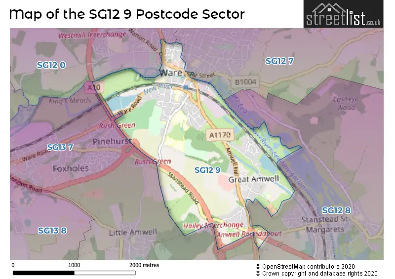
The SG12 9 Postcode shares a border with SG13 7 (HERTFORD, Hertford Heath, Hailey), SG12 0 (WARE, Dane End, Thundridge), SG12 7 (WARE, Wareside, Thundridge) and SG12 8 (Stanstead Abbotts, Hunsdon, Widford).
The sector is within the post town of WARE.
SG12 9 is a postcode sector within the SG12 postcode district which is within the SG Stevenage postcode area.
The Royal Mail delivery office for the SG12 9 postal sector is the Ware Delivery Office.
The area of the SG12 9 postcode sector is 2.09 square miles which is 5.41 square kilometres or 1,337.02 square acres.
Waterways within the SG12 9 postcode sector include the New River, River Lea Navigation, Lee Navigation.

Map of the SG12 9 Postcode Sector
Explore the SG12 9 postcode sector by using our free interactive map.
| S | G | 1 | 2 | - | 9 | X | X |
| S | G | 1 | 2 | Space | 9 | Letter | Letter |
Official List of Streets
WARE (59 Streets)
Great Amwell (20 Streets)
Unofficial Streets or Alternative Spellings
Stanstead Abbotts
STATION ROADHailey
WARE ROADWARE
BOWLING ROAD CHURCH ROW COLLETT ROAD NEW ROAD STAR STREET THE BOURNE WADESMILL ROAD WATTON ROAD AMWELL HILL AMWELL ROUNDABOUT BLACK SMITHS CLOSE CAMERON COURT CHARVILLES ROUNDABOUT COMMON WHARF GEORGE WALK GLAXO FOOTBRIDGE HAILEY INTERCHANGE KINGSMEAD VIADUCT LOXLEY COURT MILLACRES MONKS ROW NEW RIVER COURT NEW RIVER PATH OMEGA COURT RUSH GREEN ROUNDABOUT ST EVROUL COURT STATION COURT STEWART PLACE THE CARRIAGES THIEVES LANE VINE COURT WAGGONERS YARD WICKHAMS WHARFHERTFORD
STANSTEAD ROAD WARE ROADWeather Forecast for SG12 9
Press Button to Show Forecast for Ware
| Time Period | Icon | Description | Temperature | Rain Probability | Wind |
|---|---|---|---|---|---|
| 09:00 to 12:00 | Cloudy | 17.0°C (feels like 15.0°C) | 4.00% | S 11 mph | |
| 12:00 to 15:00 | Overcast | 19.0°C (feels like 16.0°C) | 7.00% | S 13 mph | |
| 15:00 to 18:00 | Cloudy | 20.0°C (feels like 16.0°C) | 4.00% | SSE 13 mph | |
| 18:00 to 21:00 | Cloudy | 19.0°C (feels like 16.0°C) | 6.00% | SSE 11 mph | |
| 21:00 to 00:00 | Cloudy | 16.0°C (feels like 15.0°C) | 11.00% | SE 9 mph |
Press Button to Show Forecast for Ware
| Time Period | Icon | Description | Temperature | Rain Probability | Wind |
|---|---|---|---|---|---|
| 00:00 to 03:00 | Cloudy | 15.0°C (feels like 14.0°C) | 25.00% | SE 9 mph | |
| 03:00 to 06:00 | Light rain | 15.0°C (feels like 14.0°C) | 68.00% | SE 7 mph | |
| 06:00 to 09:00 | Heavy rain | 14.0°C (feels like 14.0°C) | 92.00% | SE 7 mph | |
| 09:00 to 12:00 | Heavy rain | 14.0°C (feels like 13.0°C) | 91.00% | SSE 7 mph | |
| 12:00 to 15:00 | Light rain | 14.0°C (feels like 13.0°C) | 46.00% | SSE 9 mph | |
| 15:00 to 18:00 | Light rain | 15.0°C (feels like 14.0°C) | 50.00% | SSE 9 mph | |
| 18:00 to 21:00 | Cloudy | 16.0°C (feels like 14.0°C) | 9.00% | SE 9 mph | |
| 21:00 to 00:00 | Cloudy | 14.0°C (feels like 12.0°C) | 7.00% | SE 9 mph |
Press Button to Show Forecast for Ware
| Time Period | Icon | Description | Temperature | Rain Probability | Wind |
|---|---|---|---|---|---|
| 00:00 to 03:00 | Cloudy | 13.0°C (feels like 12.0°C) | 7.00% | SE 7 mph | |
| 03:00 to 06:00 | Cloudy | 12.0°C (feels like 11.0°C) | 9.00% | ESE 7 mph | |
| 06:00 to 09:00 | Cloudy | 13.0°C (feels like 12.0°C) | 13.00% | SE 7 mph | |
| 09:00 to 12:00 | Cloudy | 16.0°C (feels like 15.0°C) | 11.00% | SE 7 mph | |
| 12:00 to 15:00 | Cloudy | 18.0°C (feels like 17.0°C) | 12.00% | SE 7 mph | |
| 15:00 to 18:00 | Light rain shower (day) | 19.0°C (feels like 17.0°C) | 26.00% | SE 9 mph | |
| 18:00 to 21:00 | Sunny day | 18.0°C (feels like 17.0°C) | 4.00% | SE 7 mph | |
| 21:00 to 00:00 | Clear night | 13.0°C (feels like 12.0°C) | 2.00% | ESE 4 mph |
Press Button to Show Forecast for Ware
| Time Period | Icon | Description | Temperature | Rain Probability | Wind |
|---|---|---|---|---|---|
| 00:00 to 03:00 | Clear night | 11.0°C (feels like 10.0°C) | 3.00% | E 4 mph | |
| 03:00 to 06:00 | Cloudy | 10.0°C (feels like 9.0°C) | 6.00% | E 4 mph | |
| 06:00 to 09:00 | Cloudy | 12.0°C (feels like 12.0°C) | 6.00% | E 4 mph | |
| 09:00 to 12:00 | Cloudy | 16.0°C (feels like 16.0°C) | 8.00% | SSW 4 mph | |
| 12:00 to 15:00 | Cloudy | 18.0°C (feels like 17.0°C) | 16.00% | SSW 4 mph | |
| 15:00 to 18:00 | Light rain shower (day) | 18.0°C (feels like 17.0°C) | 32.00% | SSE 4 mph | |
| 18:00 to 21:00 | Light rain shower (day) | 17.0°C (feels like 16.0°C) | 30.00% | WSW 4 mph | |
| 21:00 to 00:00 | Cloudy | 14.0°C (feels like 13.0°C) | 8.00% | WSW 4 mph |
Press Button to Show Forecast for Ware
| Time Period | Icon | Description | Temperature | Rain Probability | Wind |
|---|---|---|---|---|---|
| 00:00 to 03:00 | Cloudy | 12.0°C (feels like 12.0°C) | 6.00% | WSW 4 mph | |
| 03:00 to 06:00 | Clear night | 11.0°C (feels like 10.0°C) | 6.00% | W 4 mph | |
| 06:00 to 09:00 | Overcast | 12.0°C (feels like 11.0°C) | 12.00% | W 4 mph | |
| 09:00 to 12:00 | Overcast | 16.0°C (feels like 15.0°C) | 10.00% | W 7 mph | |
| 12:00 to 15:00 | Light rain shower (day) | 18.0°C (feels like 18.0°C) | 35.00% | WNW 7 mph | |
| 15:00 to 18:00 | Light rain shower (day) | 19.0°C (feels like 18.0°C) | 38.00% | NW 7 mph | |
| 18:00 to 21:00 | Cloudy | 18.0°C (feels like 17.0°C) | 17.00% | WNW 7 mph | |
| 21:00 to 00:00 | Cloudy | 14.0°C (feels like 14.0°C) | 10.00% | NW 7 mph |
Schools and Places of Education Within the SG12 9 Postcode Sector
Hertford Regional College
Further education
Scotts Road, Ware, Hertfordshire, SG12 9JF
Head: Mr Tony Medhurst
Ofsted Rating: Good
Inspection: 2021-11-05 (920 days ago)
Website: Visit Hertford Regional College Website
Phone: 01992411400
Number of Pupils: 0
Middleton School
Community special school
Walnut Tree Walk, Ware, Hertfordshire, SG12 9PD
Head: Mrs Debbie Hartley
Ofsted Rating: Outstanding
Inspection: 2023-06-22 (326 days ago)
Website: Visit Middleton School Website
Phone: 01920485152
Number of Pupils: 100
Pinewood School
Academy special converter
Hoe Lane, Ware, Hertfordshire, SG12 9PB
Head: Mr Todd Baines
Ofsted Rating: Requires improvement
Inspection: 2023-10-04 (222 days ago)
Website: Visit Pinewood School Website
Phone: 01920412211
Number of Pupils: 204
St John the Baptist Voluntary Aided Church of England Primary School
Voluntary aided school
Hillside Lane, Ware, Hertfordshire, SG12 9SE
Head: Miss Lydia Hunt
Ofsted Rating: Good
Inspection: 2019-06-12 (1797 days ago)
Website: Visit St John the Baptist Voluntary Aided Church of England Primary School Website
Phone: 01920870135
Number of Pupils: 176
House Prices in the SG12 9 Postcode Sector
| Type of Property | 2018 Average | 2018 Sales | 2017 Average | 2017 Sales | 2016 Average | 2016 Sales | 2015 Average | 2015 Sales |
|---|---|---|---|---|---|---|---|---|
| Detached | £759,804 | 23 | £936,750 | 15 | £769,025 | 16 | £554,753 | 31 |
| Semi-Detached | £594,684 | 19 | £526,878 | 15 | £429,375 | 4 | £474,552 | 19 |
| Terraced | £380,375 | 16 | £455,178 | 21 | £432,250 | 26 | £347,975 | 23 |
| Flats | £284,688 | 77 | £274,267 | 86 | £247,886 | 68 | £220,960 | 79 |
Important Postcodes SG12 9 in the Postcode Sector
SG12 9AD is the postcode for Hertfordshire County Council, Ware Library, 87 High Street
SG12 9EF is the postcode for Church Street Surgery, 2 St. Marys Courtyard, Church Street
SG12 9HY is the postcode for Sacred Heart Catholic Primary School, Broadmeads
SG12 9NX is the postcode for Presdales School, Hoe Lane, and SCIENCE, ART & TECH, Presdales School, Hoe Lane
SG12 9PB is the postcode for Pinewood School, Hoe Lane, and PINEWOOD SCHOOL, HOE LANE, WARE
SG12 9PD is the postcode for Middleton School, Walnut Tree Walk
SG12 9SE is the postcode for St. John The Baptist VA C of E Primary School, Great Amwell
| The SG12 9 Sector is within these Local Authorities |
|
|---|---|
| The SG12 9 Sector is within these Counties |
|
| The SG12 9 Sector is within these Water Company Areas |
|