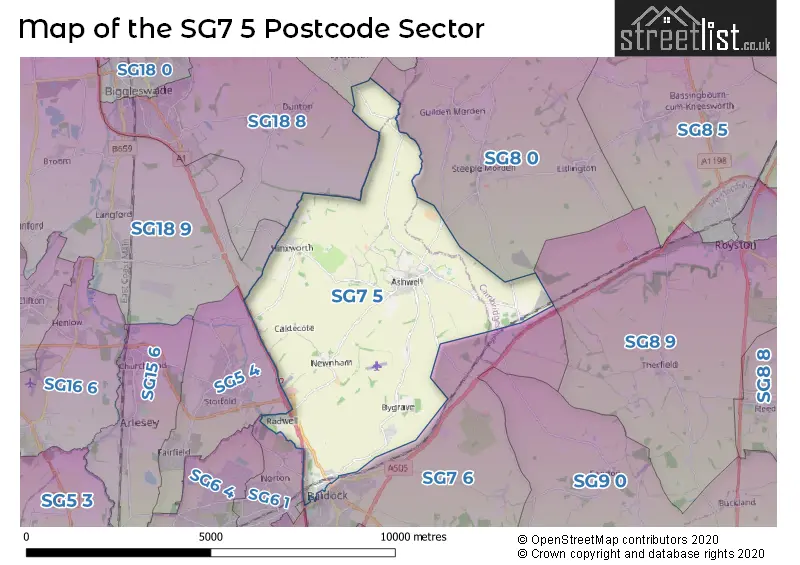
The SG7 5 postcode sector lies where the three counties of Bedfordshire, Cambridgeshire, and Hertfordshire meet.
Did you know? According to the 2021 Census, the SG7 5 postcode sector is home to a bustling 4,762 residents!
Given that each sector allows for 400 unique postcode combinations. Letters C, I, K, M, O and V are not allowed in the last two letters of a postcode. With 201 postcodes already in use, this leaves 199 units available.
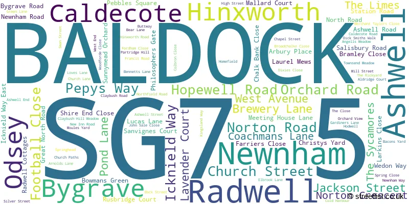
The largest settlement in the SG7 5 postal code is Ashwell followed by BALDOCK, and Hinxworth.
The SG7 5 Postcode shares a border with SG8 9 (ROYSTON, Therfield, Kelshall), SG18 8 (BIGGLESWADE, Dunton, Stratton Business Park), SG18 9 (Langford, Upper Caldecote, Broom), SG19 2 (Potton, SANDY, Wrestlingworth), SG5 4 (Stotfold, Fairfield), SG6 1 (LETCHWORTH GARDEN CITY), SG7 6 (BALDOCK, Clothall, Wallington) and SG8 0 (Steeple Morden, Guilden Morden, Litlington).
The sector is within the post town of BALDOCK.
SG7 5 is a postcode sector within the SG7 postcode district which is within the SG Stevenage postcode area.
The Royal Mail delivery office for the SG7 5 postal sector is the Ashwell Scale Payment Delivery Office and Letchworth Delivery Office.
The area of the SG7 5 postcode sector is 15.74 square miles which is 40.76 square kilometres or 10,072.22 square acres.
The SG7 5 postcode sector is crossed by the A1M Major A road.
The SG7 5 postcode sector is crossed by the A1 Major A road.
Waterways within the SG7 5 postcode sector include the River Ivel.

Map of the SG7 5 Postcode Sector
Explore the SG7 5 postcode sector by using our free interactive map.
| S | G | 7 | - | 5 | X | X |
| S | G | 7 | Space | 5 | Letter | Letter |
Official List of Streets
BALDOCK (30 Streets)
Ashwell (46 Streets)
Hinxworth (10 Streets)
Newnham (3 Streets)
Radwell (3 Streets)
Unofficial Streets or Alternative Spellings
Ashwell
MOULES YARDBIGGLESWADE
LONDON ROADBALDOCK
HITCHIN STREET LETCHWORTH ROAD ROYSTON ROAD SUN STREET THE GARDENS WESTON WAYStotfold
NORTON ROADGuilden Morden
ASHWELL ROADWeather Forecast for SG7 5
Press Button to Show Forecast for Baldock
| Time Period | Icon | Description | Temperature | Rain Probability | Wind |
|---|---|---|---|---|---|
| 15:00 to 18:00 | Cloudy | 11.0°C (feels like 10.0°C) | 5.00% | NE 4 mph | |
| 18:00 to 21:00 | Cloudy | 9.0°C (feels like 7.0°C) | 5.00% | ENE 9 mph | |
| 21:00 to 00:00 | Cloudy | 7.0°C (feels like 5.0°C) | 9.00% | E 7 mph |
Press Button to Show Forecast for Baldock
| Time Period | Icon | Description | Temperature | Rain Probability | Wind |
|---|---|---|---|---|---|
| 00:00 to 03:00 | Cloudy | 6.0°C (feels like 3.0°C) | 11.00% | ENE 7 mph | |
| 03:00 to 06:00 | Cloudy | 5.0°C (feels like 2.0°C) | 15.00% | NE 7 mph | |
| 06:00 to 09:00 | Light rain | 5.0°C (feels like 3.0°C) | 48.00% | NE 9 mph | |
| 09:00 to 12:00 | Light rain | 7.0°C (feels like 4.0°C) | 47.00% | NE 11 mph | |
| 12:00 to 15:00 | Overcast | 9.0°C (feels like 6.0°C) | 17.00% | NE 11 mph | |
| 15:00 to 18:00 | Cloudy | 10.0°C (feels like 8.0°C) | 16.00% | NE 11 mph | |
| 18:00 to 21:00 | Overcast | 9.0°C (feels like 7.0°C) | 19.00% | NE 11 mph | |
| 21:00 to 00:00 | Light rain | 8.0°C (feels like 5.0°C) | 61.00% | NE 11 mph |
Press Button to Show Forecast for Baldock
| Time Period | Icon | Description | Temperature | Rain Probability | Wind |
|---|---|---|---|---|---|
| 00:00 to 03:00 | Heavy rain | 7.0°C (feels like 4.0°C) | 85.00% | NNE 11 mph | |
| 03:00 to 06:00 | Heavy rain | 7.0°C (feels like 4.0°C) | 89.00% | NNE 11 mph | |
| 06:00 to 09:00 | Heavy rain | 8.0°C (feels like 5.0°C) | 88.00% | NE 9 mph | |
| 09:00 to 12:00 | Heavy rain | 8.0°C (feels like 6.0°C) | 86.00% | NNW 9 mph | |
| 12:00 to 15:00 | Heavy rain | 9.0°C (feels like 6.0°C) | 79.00% | NNW 11 mph | |
| 15:00 to 18:00 | Light rain | 10.0°C (feels like 7.0°C) | 49.00% | WNW 11 mph | |
| 18:00 to 21:00 | Cloudy | 10.0°C (feels like 8.0°C) | 9.00% | WNW 7 mph | |
| 21:00 to 00:00 | Cloudy | 8.0°C (feels like 6.0°C) | 6.00% | SW 7 mph |
Press Button to Show Forecast for Baldock
| Time Period | Icon | Description | Temperature | Rain Probability | Wind |
|---|---|---|---|---|---|
| 00:00 to 03:00 | Clear night | 7.0°C (feels like 4.0°C) | 2.00% | SSW 7 mph | |
| 03:00 to 06:00 | Clear night | 5.0°C (feels like 3.0°C) | 2.00% | SSW 7 mph | |
| 06:00 to 09:00 | Sunny day | 6.0°C (feels like 4.0°C) | 1.00% | S 7 mph | |
| 09:00 to 12:00 | Partly cloudy (day) | 11.0°C (feels like 9.0°C) | 1.00% | S 9 mph | |
| 12:00 to 15:00 | Cloudy | 13.0°C (feels like 11.0°C) | 5.00% | S 11 mph | |
| 15:00 to 18:00 | Partly cloudy (day) | 15.0°C (feels like 12.0°C) | 2.00% | S 11 mph | |
| 18:00 to 21:00 | Sunny day | 13.0°C (feels like 11.0°C) | 1.00% | S 9 mph | |
| 21:00 to 00:00 | Clear night | 9.0°C (feels like 7.0°C) | 1.00% | SE 9 mph |
Press Button to Show Forecast for Baldock
| Time Period | Icon | Description | Temperature | Rain Probability | Wind |
|---|---|---|---|---|---|
| 00:00 to 03:00 | Clear night | 8.0°C (feels like 6.0°C) | 1.00% | SE 7 mph | |
| 03:00 to 06:00 | Clear night | 8.0°C (feels like 5.0°C) | 4.00% | SE 7 mph | |
| 06:00 to 09:00 | Sunny day | 9.0°C (feels like 7.0°C) | 6.00% | ESE 7 mph | |
| 09:00 to 12:00 | Cloudy | 13.0°C (feels like 11.0°C) | 7.00% | SE 9 mph | |
| 12:00 to 15:00 | Cloudy | 15.0°C (feels like 13.0°C) | 10.00% | SE 11 mph | |
| 15:00 to 18:00 | Cloudy | 16.0°C (feels like 14.0°C) | 11.00% | SE 9 mph | |
| 18:00 to 21:00 | Light rain shower (day) | 15.0°C (feels like 13.0°C) | 30.00% | ESE 9 mph | |
| 21:00 to 00:00 | Cloudy | 11.0°C (feels like 10.0°C) | 10.00% | ESE 7 mph |
Schools and Places of Education Within the SG7 5 Postcode Sector
Ashwell Primary School
Community school
Silver Street, Baldock, Hertfordshire, SG7 5QL
Head: Mr Simon England
Ofsted Rating: Good
Inspection: 2022-05-12 (715 days ago)
Website: Visit Ashwell Primary School Website
Phone: 01462742297
Number of Pupils: 216
House Prices in the SG7 5 Postcode Sector
| Type of Property | 2018 Average | 2018 Sales | 2017 Average | 2017 Sales | 2016 Average | 2016 Sales | 2015 Average | 2015 Sales |
|---|---|---|---|---|---|---|---|---|
| Detached | £644,333 | 12 | £758,810 | 21 | £702,958 | 24 | £627,723 | 20 |
| Semi-Detached | £419,050 | 12 | £414,622 | 20 | £415,033 | 15 | £354,079 | 35 |
| Terraced | £318,949 | 25 | £317,263 | 15 | £297,890 | 26 | £316,729 | 29 |
| Flats | £239,456 | 32 | £242,263 | 26 | £166,663 | 15 | £167,675 | 16 |
Important Postcodes SG7 5 in the Postcode Sector
SG7 5QL is the postcode for Ashwell Primary School, Silver Street, Ashwell, and Ashwell Primary School, Silver Street
| The SG7 5 Sector is within these Local Authorities |
|
|---|---|
| The SG7 5 Sector is within these Counties |
|
| The SG7 5 Sector is within these Water Company Areas |
|
Tourist Attractions within the SG7 5 Postcode Area
We found 1 visitor attractions within the SG7 postcode area
| Ashwell Village Museum |
|---|
| Museums & Art Galleries |
| Museum and / or Art Gallery |
| View Ashwell Village Museum on Google Maps |