The SK17 9 postcode sector is within the county of Derbyshire.
Did you know? According to the 2021 Census, the SK17 9 postcode sector is home to a bustling 8,175 residents!
Given that each sector allows for 400 unique postcode combinations. Letters C, I, K, M, O and V are not allowed in the last two letters of a postcode. With 270 postcodes already in use, this leaves 130 units available.
The largest settlement in the SK17 9 postal code is BUXTON followed by Taddington, and Flagg.
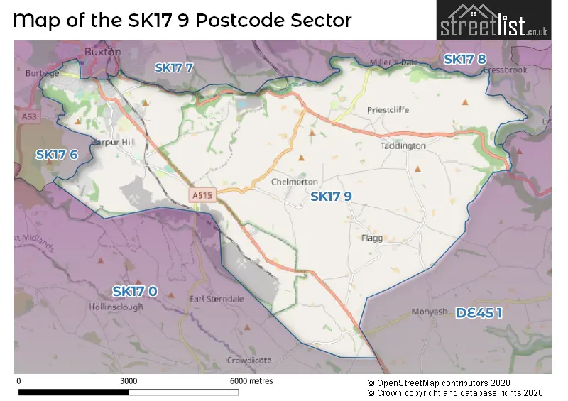
The SK17 9 Postcode shares a border with SK17 7 (BUXTON, Fairfield, Green Fairfield), DE45 1 (BAKEWELL, Youlgrave, Baslow), SK17 0 (Longnor, Hartington, Quarnford), SK17 6 (BUXTON, Ladmanlow) and SK17 8 (Tideswell, Dove Holes, Peak Dale).
The sector is within the post town of BUXTON.
SK17 9 is a postcode sector within the SK17 postcode district which is within the SK Stockport postcode area.
The Royal Mail delivery office for the SK17 9 postal sector is the Buxton (sk) Delivery Office.
The area of the SK17 9 postcode sector is 23.16 square miles which is 59.99 square kilometres or 14,824.39 square acres.
Waterways within the SK17 9 postcode sector include the River Wye.

Map of the SK17 9 Postcode Sector
Explore the SK17 9 postcode sector by using our free interactive map.
| S | K | 1 | 7 | - | 9 | X | X |
| S | K | 1 | 7 | Space | 9 | Letter | Letter |
Official List of Streets
BUXTON (125 Streets)
Harpur Hill (4 Streets)
Chelmorton (6 Streets)
Taddington (11 Streets)
Unofficial Streets or Alternative Spellings
Monyash
TAGG LANENewton Grange
BUXTON ROADBUXTON
BATH ROAD BENNETT STREET BYRON STREET DALE ROAD HEATH PARK ROAD HEATH STREET MACCLESFIELD OLD ROAD NEWSTEAD TERRACE WEST ROADLongnor
BUXTON ROAD LEEK ROADWeather Forecast for SK17 9
Press Button to Show Forecast for Ravenstor Youth Hostel
| Time Period | Icon | Description | Temperature | Rain Probability | Wind |
|---|---|---|---|---|---|
| 18:00 to 21:00 | Cloudy | 6.0°C (feels like 3.0°C) | 40.00% | E 9 mph | |
| 21:00 to 00:00 | Cloudy | 4.0°C (feels like 1.0°C) | 4.00% | ENE 7 mph |
Press Button to Show Forecast for Ravenstor Youth Hostel
| Time Period | Icon | Description | Temperature | Rain Probability | Wind |
|---|---|---|---|---|---|
| 00:00 to 03:00 | Cloudy | 3.0°C (feels like 1.0°C) | 5.00% | ENE 7 mph | |
| 03:00 to 06:00 | Cloudy | 3.0°C (feels like 0.0°C) | 8.00% | NE 7 mph | |
| 06:00 to 09:00 | Cloudy | 3.0°C (feels like 0.0°C) | 7.00% | NE 9 mph | |
| 09:00 to 12:00 | Cloudy | 6.0°C (feels like 3.0°C) | 10.00% | ENE 11 mph | |
| 12:00 to 15:00 | Overcast | 7.0°C (feels like 4.0°C) | 20.00% | ENE 11 mph | |
| 15:00 to 18:00 | Overcast | 7.0°C (feels like 5.0°C) | 19.00% | ENE 11 mph | |
| 18:00 to 21:00 | Cloudy | 7.0°C (feels like 4.0°C) | 9.00% | ENE 11 mph | |
| 21:00 to 00:00 | Cloudy | 5.0°C (feels like 2.0°C) | 6.00% | NE 9 mph |
Press Button to Show Forecast for Ravenstor Youth Hostel
| Time Period | Icon | Description | Temperature | Rain Probability | Wind |
|---|---|---|---|---|---|
| 00:00 to 03:00 | Cloudy | 4.0°C (feels like 1.0°C) | 10.00% | NE 11 mph | |
| 03:00 to 06:00 | Cloudy | 4.0°C (feels like 0.0°C) | 49.00% | NNE 13 mph | |
| 06:00 to 09:00 | Light rain | 4.0°C (feels like 0.0°C) | 54.00% | NNE 11 mph | |
| 09:00 to 12:00 | Light rain | 5.0°C (feels like 2.0°C) | 53.00% | N 11 mph | |
| 12:00 to 15:00 | Overcast | 7.0°C (feels like 4.0°C) | 22.00% | NW 11 mph | |
| 15:00 to 18:00 | Cloudy | 8.0°C (feels like 6.0°C) | 16.00% | WNW 11 mph | |
| 18:00 to 21:00 | Partly cloudy (day) | 8.0°C (feels like 6.0°C) | 5.00% | W 9 mph | |
| 21:00 to 00:00 | Clear night | 4.0°C (feels like 2.0°C) | 3.00% | WSW 7 mph |
Press Button to Show Forecast for Ravenstor Youth Hostel
| Time Period | Icon | Description | Temperature | Rain Probability | Wind |
|---|---|---|---|---|---|
| 00:00 to 03:00 | Clear night | 4.0°C (feels like 1.0°C) | 2.00% | SW 7 mph | |
| 03:00 to 06:00 | Clear night | 3.0°C (feels like 0.0°C) | 1.00% | SSW 7 mph | |
| 06:00 to 09:00 | Sunny day | 5.0°C (feels like 2.0°C) | 1.00% | S 7 mph | |
| 09:00 to 12:00 | Partly cloudy (day) | 9.0°C (feels like 6.0°C) | 2.00% | S 13 mph | |
| 12:00 to 15:00 | Cloudy | 11.0°C (feels like 9.0°C) | 7.00% | S 13 mph | |
| 15:00 to 18:00 | Cloudy | 12.0°C (feels like 9.0°C) | 7.00% | S 13 mph | |
| 18:00 to 21:00 | Partly cloudy (day) | 11.0°C (feels like 9.0°C) | 3.00% | SSE 11 mph | |
| 21:00 to 00:00 | Clear night | 8.0°C (feels like 6.0°C) | 2.00% | SSE 9 mph |
Press Button to Show Forecast for Ravenstor Youth Hostel
| Time Period | Icon | Description | Temperature | Rain Probability | Wind |
|---|---|---|---|---|---|
| 00:00 to 03:00 | Clear night | 7.0°C (feels like 4.0°C) | 3.00% | SE 9 mph | |
| 03:00 to 06:00 | Clear night | 5.0°C (feels like 3.0°C) | 2.00% | ESE 9 mph | |
| 06:00 to 09:00 | Sunny day | 7.0°C (feels like 5.0°C) | 2.00% | ESE 9 mph | |
| 09:00 to 12:00 | Partly cloudy (day) | 11.0°C (feels like 9.0°C) | 5.00% | ESE 11 mph | |
| 12:00 to 15:00 | Partly cloudy (day) | 13.0°C (feels like 11.0°C) | 7.00% | ESE 13 mph | |
| 15:00 to 18:00 | Cloudy | 14.0°C (feels like 12.0°C) | 13.00% | ESE 11 mph | |
| 18:00 to 21:00 | Cloudy | 13.0°C (feels like 11.0°C) | 13.00% | ESE 9 mph | |
| 21:00 to 00:00 | Cloudy | 10.0°C (feels like 8.0°C) | 9.00% | E 7 mph |
Schools and Places of Education Within the SK17 9 Postcode Sector
Burbage Primary School
Community school
Cavendish Avenue, Buxton, Derbyshire, SK17 9AE
Head: Mr Anthony Tierney
Ofsted Rating: Good
Inspection: 2023-09-20 (219 days ago)
Website: Visit Burbage Primary School Website
Phone: 0129822278
Number of Pupils: 348
Buxton Junior School
Community school
Buxton Junior School, Buxton, Derbyshire, SK17 9DR
Head: Mrs Ros Carter
Ofsted Rating: Good
Inspection: 2023-03-29 (394 days ago)
Website: Visit Buxton Junior School Website
Phone: 0129822156
Number of Pupils: 238
Flagg Nursery School
Local authority nursery school
Main Road, Near Buxton, Derbyshire, SK17 9QT
Head: Mrs Sarah Brown
Ofsted Rating: Outstanding
Inspection: 2019-03-05 (1879 days ago)
Website: Visit Flagg Nursery School Website
Phone: 0129885208
Number of Pupils: 56
Harpur Hill Primary School
Community school
Trent Avenue, Buxton, Derbyshire, SK17 9LP
Head: Mrs Vicky Giliker
Ofsted Rating: Good
Inspection: 2019-02-28 (1884 days ago)
Website: Visit Harpur Hill Primary School Website
Phone: 0129823261
Number of Pupils: 287
Taddington and Priestcliffe School
Voluntary aided school
Taddington, Buxton, Derbyshire, SK17 9TW
Head: Mr James Handley
Ofsted Rating: Good
Inspection: 2018-03-08 (2241 days ago)
Website: Visit Taddington and Priestcliffe School Website
Phone: 0129885278
Number of Pupils: 59
House Prices in the SK17 9 Postcode Sector
| Type of Property | 2018 Average | 2018 Sales | 2017 Average | 2017 Sales | 2016 Average | 2016 Sales | 2015 Average | 2015 Sales |
|---|---|---|---|---|---|---|---|---|
| Detached | £372,050 | 33 | £333,879 | 38 | £341,887 | 49 | £308,299 | 41 |
| Semi-Detached | £220,997 | 41 | £215,803 | 56 | £203,480 | 53 | £184,404 | 53 |
| Terraced | £191,200 | 22 | £178,222 | 25 | £189,896 | 26 | £198,784 | 28 |
| Flats | £131,159 | 11 | £207,204 | 12 | £161,279 | 7 | £144,177 | 11 |
Important Postcodes SK17 9 in the Postcode Sector
SK17 9AT is the postcode for MAIN BUILDING, Burbage Primary School, Girdon Close, and Dovedale, Burbage Primary School, Girdon Close
SK17 9AY is the postcode for Elmwood Medical Centre, 7 Burlington Road
SK17 9BZ is the postcode for Buxton Medical Practice, 2 Temple Road
SK17 9DR is the postcode for Buxton County Junior School, Mosley Road, Buxton Junior School, Mosley Road, and BUXTON COUNTY JUNIOR SCHOOL, MOSLEY ROAD, BUXTON
SK17 9DW is the postcode for Derbyshire Fire & Rescue Service, Fire Station, Compton Grove
SK17 9DZ is the postcode for Solomon House, 19, College Road
SK17 9EA is the postcode for C BLOCK, Buxton Community School, College Road, Buxton Community School, College Road, E BLOCK, Buxton Community School, College Road, D BLOCK, Buxton Community School, College Road, F BLOCK, Buxton Community School, College Road, and B BLOCK, Buxton Community School, College Road
SK17 9HJ is the postcode for Derbyshire County Council, Buxton Social Care Area Office, Kents Bank
SK17 9HW is the postcode for Main Building, Kents Bank Complex, Kents Bank Road, and Kents Bank Complex, Kents Bank Road
SK17 9JL is the postcode for Unit 28, Harpur Hill Business Park
SK17 9JN is the postcode for NEW BUILDING, Health & Safety Executive, Harpur Hill, Health & Safety Executive, Harpur Hill, and MAIN BUILDING, Health & Safety Executive, Harpur Hill
SK17 9JY is the postcode for University of Derby, Sports Centre, Trenchard Drive
SK17 9LP is the postcode for MAIN BUILDING, Harpur Hill Primary School, Trent Avenue, MAIN BUILDING, Harpur Hill Primary School, Trent Street, and Harpur Hill Primary School, Trent Avenue
SK17 9NJ is the postcode for BUXTON HOSPITAL, LONDON ROAD, BUXTON, and Buxton Hospital, London Road
SK17 9RZ is the postcode for Buxton Fire Station, Staden Lane, and Derbyshire Fire & Rescue Service, Staden Business Park, Staden Lane
| The SK17 9 Sector is within these Local Authorities |
|
|---|---|
| The SK17 9 Sector is within these Counties |
|
| The SK17 9 Sector is within these Water Company Areas |
|
Tourist Attractions within the SK17 9 Postcode Area
We found 2 visitor attractions within the SK17 postcode area
| Go Ape! Tree Top Adventure - Buxton |
|---|
| Country Parks |
| Country Park |
| View Go Ape! Tree Top Adventure - Buxton on Google Maps |
| Poole's Cavern & Country Park |
| Country Parks |
| Country Park |
| View Poole's Cavern & Country Park on Google Maps |