The SO30 3 postcode sector is within the county of Hampshire.
Did you know? According to the 2021 Census, the SO30 3 postcode sector is home to a bustling 6,906 residents!
Given that each sector allows for 400 unique postcode combinations. Letters C, I, K, M, O and V are not allowed in the last two letters of a postcode. With 180 postcodes already in use, this leaves 220 units available.
The SO30 3 postal code covers the settlement of West End.
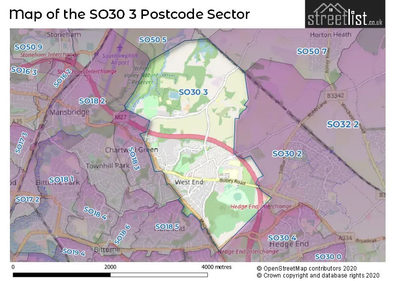
The SO30 3 Postcode shares a border with SO19 6 (SOUTHAMPTON), SO18 3 (West End), SO18 5 (SOUTHAMPTON), SO30 4 (Hedge End), SO18 2 (SOUTHAMPTON, Southampton International Airport), SO30 2 (Hedge End, Botley, Curbridge), SO50 5 (EASTLEIGH), SO50 7 (Fair Oak, Horton Heath, Fishers Pond) and SO50 8 (Bishopstoke, Fair Oak, EASTLEIGH).
The sector is within the post town of SOUTHAMPTON.
SO30 3 is a postcode sector within the SO50 postcode district which is within the SO Southampton postcode area.
The Royal Mail delivery office for the SO30 3 postal sector is the unknown.
The area of the SO30 3 postcode sector is 2.77 square miles which is 7.18 square kilometres or 1,773.54 square acres.
The SO30 3 postcode sector is crossed by the M27 motorway.
Waterways within the SO30 3 postcode sector include the River Itchen.

Map of the SO30 3 Postcode Sector
Explore the SO30 3 postcode sector by using our free interactive map.
| S | O | 3 | 0 | - | 3 | X | X |
| S | O | 3 | 0 | Space | 3 | Letter | Letter |
Official List of Streets
West End (98 Streets)
Unofficial Streets or Alternative Spellings
Hedge End
BOTLEY ROAD CHARLES WATTS WAY COMINES WAY TOLLBAR WAY UPPER NORTHAM DRIVEWest End
EDEN ROAD ALLINGTON LANE ROUNDABOUT BEACON MEWS FOREST TRAIL HALIFAX COURT HONEYSUCKLE TRAIL JUKES WALK KANES HILL ROUNDABOUT LANCASTER COURT MARSHALL DRIVE MEADOW NATURE TRAIL MULBERRY COURT OAKWOOD COURT ROSELANDS SAINT JAMES ROAD WELLINGTON COURT WESTGATE MEWS WESTWOOD COURT WOODLAND NATURE TRAIL WOODS AND MEADOWS WALKFair Oak
ALLINGTON LANESOUTHAMPTON
CHERITON AVENUE KANES HILLSchools and Places of Education Within the SO30 3 Postcode Sector
Saint James' Church of England Primary School
Voluntary controlled school
Moorgreen Road, Southampton, Hampshire, SO30 3EG
Head: Mrs Michelle Marsh
Ofsted Rating: Good
Inspection: 2018-11-15 (2029 days ago)
Website: Visit Saint James' Church of England Primary School Website
Phone: 02380900995
Number of Pupils: 603
House Prices in the SO30 3 Postcode Sector
| Type of Property | 2018 Average | 2018 Sales | 2017 Average | 2017 Sales | 2016 Average | 2016 Sales | 2015 Average | 2015 Sales |
|---|---|---|---|---|---|---|---|---|
| Detached | £415,325 | 58 | £417,061 | 41 | £433,556 | 47 | £374,560 | 55 |
| Semi-Detached | £295,521 | 45 | £307,857 | 35 | £272,073 | 32 | £245,712 | 41 |
| Terraced | £244,412 | 17 | £277,983 | 29 | £232,163 | 15 | £234,463 | 16 |
| Flats | £190,927 | 39 | £168,661 | 43 | £163,885 | 23 | £130,463 | 32 |
Important Postcodes SO30 3 in the Postcode Sector
SO30 3EG is the postcode for St James CE (C) Primary School, Moorgreen Road, and St James CE (C) Primary School, Moorgreen Road, West End
SO30 3HQ is the postcode for Itchen Valley Country Park, Highwood Barn, Allington Lane
SO30 3JB is the postcode for Southampton City PCT, Moorgreen Hospital, TOM RUDD UNIT, Moorgreen Hospital, Botley Road, HAWTHORN LODGE, Moorgreen Hospital, Botley Road, MAIN BUILDING, Moorgreen Hospital, Botley Road, Moorgreen Hospital, Botley Road, COUNTESS MOUNTBATTEN HOUSE, Moorgreen Hospital, Botley Road, STONEHAM CENTRE, Moorgreen Hospital, Botley Road, and Moorgreen Hospital- Thomas Rudd, Botley Road
SO30 3PY is the postcode for West End Surgery, Moorgreen Road
SO30 3XH is the postcode for Hilton at the Ageas Bowl, Botley Road
| The SO30 3 Sector is within these Local Authorities |
|
|---|---|
| The SO30 3 Sector is within these Counties |
|
| The SO30 3 Sector is within these Water Company Areas |
|
Tourist Attractions within the SO30 3 Postcode Area
We found 1 visitor attractions within the SO50 postcode area
| Go Ape! Tree Top Adventure - Itchen Valley |
|---|
| Country Parks |
| Country Park |
| View Go Ape! Tree Top Adventure - Itchen Valley on Google Maps |