The SR5 4 postcode sector is within the county of Tyne & Wear.
Did you know? According to the 2021 Census, the SR5 4 postcode sector is home to a bustling 5,988 residents!
Given that each sector allows for 400 unique postcode combinations. Letters C, I, K, M, O and V are not allowed in the last two letters of a postcode. With 173 postcodes already in use, this leaves 227 units available.
The SR5 4 postal code covers the settlement of SUNDERLAND.
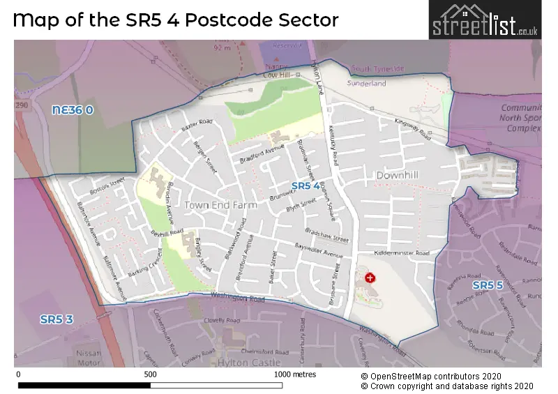
The SR5 4 Postcode shares a border with SR5 5 (SUNDERLAND), NE36 0 (EAST BOLDON, West Boldon) and SR5 3 (SUNDERLAND, Castletown, Sunderland Enterprise Park).
The sector is within the post town of SUNDERLAND.
SR5 4 is a postcode sector within the SR5 postcode district which is within the SR Sunderland postcode area.
The Royal Mail delivery office for the SR5 4 postal sector is the Sunderland Delivery Office.
The area of the SR5 4 postcode sector is 0.46 square miles which is 1.19 square kilometres or 294.12 square acres.
The SR5 4 postcode sector is crossed by the A19 Major A road.

Map of the SR5 4 Postcode Sector
Explore the SR5 4 postcode sector by using our free interactive map.
| S | R | 5 | - | 4 | X | X |
| S | R | 5 | Space | 4 | Letter | Letter |
Official List of Streets
SUNDERLAND (103 Streets)
Unofficial Streets or Alternative Spellings
SUNDERLAND
GRASMOOR VIEW MUNRO WAY RAVENSWOOD ROAD RAVENSWOOD SQUARE REEDLING COURT RUTHERFORD ROAD SCAFELL CLOSE CASTLE CRAGWest Boldon
HYLTON LANESUNDERLAND,
WASHINGTON ROADWeather Forecast for SR5 4
Press Button to Show Forecast for Castletown (Tyne & Wear)
| Time Period | Icon | Description | Temperature | Rain Probability | Wind |
|---|---|---|---|---|---|
| 18:00 to 21:00 | Cloudy | 13.0°C (feels like 12.0°C) | 13.00% | ESE 7 mph | |
| 21:00 to 00:00 | Light rain | 13.0°C (feels like 12.0°C) | 55.00% | ESE 4 mph |
Press Button to Show Forecast for Castletown (Tyne & Wear)
| Time Period | Icon | Description | Temperature | Rain Probability | Wind |
|---|---|---|---|---|---|
| 00:00 to 03:00 | Cloudy | 13.0°C (feels like 13.0°C) | 10.00% | SE 4 mph | |
| 03:00 to 06:00 | Cloudy | 12.0°C (feels like 12.0°C) | 5.00% | ESE 2 mph | |
| 06:00 to 09:00 | Cloudy | 13.0°C (feels like 12.0°C) | 7.00% | E 2 mph | |
| 09:00 to 12:00 | Cloudy | 14.0°C (feels like 13.0°C) | 7.00% | ENE 4 mph | |
| 12:00 to 15:00 | Cloudy | 15.0°C (feels like 14.0°C) | 5.00% | ENE 7 mph | |
| 15:00 to 18:00 | Cloudy | 14.0°C (feels like 13.0°C) | 5.00% | ENE 7 mph | |
| 18:00 to 21:00 | Cloudy | 13.0°C (feels like 12.0°C) | 5.00% | NE 7 mph | |
| 21:00 to 00:00 | Cloudy | 12.0°C (feels like 11.0°C) | 4.00% | NE 4 mph |
Press Button to Show Forecast for Castletown (Tyne & Wear)
| Time Period | Icon | Description | Temperature | Rain Probability | Wind |
|---|---|---|---|---|---|
| 00:00 to 03:00 | Cloudy | 11.0°C (feels like 10.0°C) | 4.00% | N 4 mph | |
| 03:00 to 06:00 | Cloudy | 11.0°C (feels like 10.0°C) | 14.00% | NNW 4 mph | |
| 06:00 to 09:00 | Cloudy | 12.0°C (feels like 11.0°C) | 15.00% | NNW 4 mph | |
| 09:00 to 12:00 | Partly cloudy (day) | 14.0°C (feels like 14.0°C) | 4.00% | NNE 4 mph | |
| 12:00 to 15:00 | Partly cloudy (day) | 16.0°C (feels like 15.0°C) | 2.00% | NE 7 mph | |
| 15:00 to 18:00 | Sunny day | 15.0°C (feels like 14.0°C) | 1.00% | ENE 9 mph | |
| 18:00 to 21:00 | Sunny day | 14.0°C (feels like 13.0°C) | 0.00% | ENE 9 mph | |
| 21:00 to 00:00 | Clear night | 12.0°C (feels like 11.0°C) | 1.00% | NE 7 mph |
Press Button to Show Forecast for Castletown (Tyne & Wear)
| Time Period | Icon | Description | Temperature | Rain Probability | Wind |
|---|---|---|---|---|---|
| 00:00 to 03:00 | Clear night | 11.0°C (feels like 10.0°C) | 1.00% | N 7 mph | |
| 03:00 to 06:00 | Partly cloudy (night) | 11.0°C (feels like 10.0°C) | 3.00% | N 7 mph | |
| 06:00 to 09:00 | Partly cloudy (day) | 12.0°C (feels like 11.0°C) | 5.00% | N 7 mph | |
| 09:00 to 12:00 | Partly cloudy (day) | 14.0°C (feels like 13.0°C) | 5.00% | NNE 9 mph | |
| 12:00 to 15:00 | Partly cloudy (day) | 15.0°C (feels like 14.0°C) | 5.00% | NE 9 mph | |
| 15:00 to 18:00 | Partly cloudy (day) | 15.0°C (feels like 14.0°C) | 5.00% | NE 9 mph | |
| 18:00 to 21:00 | Cloudy | 14.0°C (feels like 13.0°C) | 6.00% | NE 9 mph | |
| 21:00 to 00:00 | Cloudy | 12.0°C (feels like 11.0°C) | 6.00% | NE 7 mph |
Press Button to Show Forecast for Castletown (Tyne & Wear)
| Time Period | Icon | Description | Temperature | Rain Probability | Wind |
|---|---|---|---|---|---|
| 00:00 to 03:00 | Cloudy | 12.0°C (feels like 11.0°C) | 8.00% | N 7 mph | |
| 03:00 to 06:00 | Overcast | 11.0°C (feels like 10.0°C) | 11.00% | N 7 mph | |
| 06:00 to 09:00 | Cloudy | 12.0°C (feels like 10.0°C) | 10.00% | N 9 mph | |
| 09:00 to 12:00 | Partly cloudy (day) | 14.0°C (feels like 12.0°C) | 5.00% | NNE 11 mph | |
| 12:00 to 15:00 | Partly cloudy (day) | 15.0°C (feels like 13.0°C) | 7.00% | NNE 11 mph | |
| 15:00 to 18:00 | Partly cloudy (day) | 15.0°C (feels like 13.0°C) | 5.00% | NNE 11 mph | |
| 18:00 to 21:00 | Sunny day | 14.0°C (feels like 12.0°C) | 3.00% | NNE 9 mph | |
| 21:00 to 00:00 | Clear night | 12.0°C (feels like 10.0°C) | 2.00% | NNE 7 mph |
Schools and Places of Education Within the SR5 4 Postcode Sector
Bexhill Academy
Academy converter
Bexhill Road, Sunderland, Tyne and Wear, SR5 4PJ
Head: Headteacher Ruth Walton
Ofsted Rating: Outstanding
Inspection: 2022-06-09 (705 days ago)
Website: Visit Bexhill Academy Website
Phone: 01917070120
Number of Pupils: 347
Town End Academy
Academy converter
Borodin Avenue, Sunderland, Tyne and Wear, SR5 4NX
Head: Mrs Christine Robson
Ofsted Rating: Good
Inspection: 2020-01-23 (1573 days ago)
Website: Visit Town End Academy Website
Phone: 01917070123
Number of Pupils: 240
House Prices in the SR5 4 Postcode Sector
| Type of Property | 2018 Average | 2018 Sales | 2017 Average | 2017 Sales | 2016 Average | 2016 Sales | 2015 Average | 2015 Sales |
|---|---|---|---|---|---|---|---|---|
| Detached | £112,000 | 1 | £0 | 0 | £96,000 | 1 | £0 | 0 |
| Semi-Detached | £80,591 | 16 | £79,733 | 15 | £74,005 | 19 | £72,861 | 19 |
| Terraced | £70,012 | 26 | £80,759 | 16 | £79,540 | 25 | £78,387 | 19 |
| Flats | £37,575 | 6 | £37,500 | 9 | £39,600 | 5 | £31,998 | 2 |
Important Postcodes SR5 4 in the Postcode Sector
SR5 4BB is the postcode for Community North Sports Complex, Kingsway Road
SR5 4BW is the postcode for Bunny Hill Centre, Hylton Lane, and Bunny Hill Primary Care Centre, Hylton Lane
SR5 4EU is the postcode for Farmborough Court Intermediate Care Centre, Brentford Avenue
SR5 4JW is the postcode for St. John Bosco RC Primary School, Bradford Avenue
SR5 4NX is the postcode for Town End Academy, Borodin Avenue
SR5 4PG is the postcode for Department Of Social Services, 2 Blackwood Road
SR5 4PJ is the postcode for Bexhill Academy, Bexhill Road
| The SR5 4 Sector is within these Local Authorities |
|
|---|---|
| The SR5 4 Sector is within these Counties |
|
| The SR5 4 Sector is within these Water Company Areas |
|