The SR5 5 postcode sector is within the county of Tyne & Wear.
Did you know? According to the 2021 Census, the SR5 5 postcode sector is home to a bustling 9,165 residents!
Given that each sector allows for 400 unique postcode combinations. Letters C, I, K, M, O and V are not allowed in the last two letters of a postcode. With 209 postcodes already in use, this leaves 191 units available.
The SR5 5 postal code covers the settlement of SUNDERLAND.
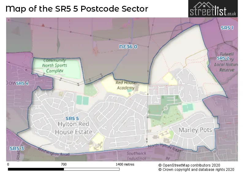
The SR5 5 Postcode shares a border with SR5 4 (SUNDERLAND), NE36 0 (EAST BOLDON, West Boldon), SR5 1 (SUNDERLAND), SR5 2 (SUNDERLAND, Southwick, Sunderland Enterprise Park) and SR5 3 (SUNDERLAND, Castletown, Sunderland Enterprise Park).
The sector is within the post town of SUNDERLAND.
SR5 5 is a postcode sector within the SR5 postcode district which is within the SR Sunderland postcode area.
The Royal Mail delivery office for the SR5 5 postal sector is the Sunderland Delivery Office.
The area of the SR5 5 postcode sector is 0.99 square miles which is 2.55 square kilometres or 630.95 square acres.

Map of the SR5 5 Postcode Sector
Explore the SR5 5 postcode sector by using our free interactive map.
| S | R | 5 | - | 5 | X | X |
| S | R | 5 | Space | 5 | Letter | Letter |
Official List of Streets
SUNDERLAND (129 Streets)
Unofficial Streets or Alternative Spellings
Weather Forecast for SR5 5
Press Button to Show Forecast for Southwick (Tyne & Wear)
| Time Period | Icon | Description | Temperature | Rain Probability | Wind |
|---|---|---|---|---|---|
| 06:00 to 09:00 | Cloudy | 12.0°C (feels like 10.0°C) | 5.00% | ESE 9 mph | |
| 09:00 to 12:00 | Heavy rain | 12.0°C (feels like 11.0°C) | 88.00% | ESE 7 mph | |
| 12:00 to 15:00 | Heavy rain | 12.0°C (feels like 10.0°C) | 88.00% | E 11 mph | |
| 15:00 to 18:00 | Cloudy | 13.0°C (feels like 11.0°C) | 11.00% | ESE 9 mph | |
| 18:00 to 21:00 | Cloudy | 13.0°C (feels like 12.0°C) | 12.00% | ESE 7 mph | |
| 21:00 to 00:00 | Light rain | 12.0°C (feels like 12.0°C) | 55.00% | ESE 7 mph |
Press Button to Show Forecast for Southwick (Tyne & Wear)
| Time Period | Icon | Description | Temperature | Rain Probability | Wind |
|---|---|---|---|---|---|
| 00:00 to 03:00 | Cloudy | 13.0°C (feels like 13.0°C) | 11.00% | SE 4 mph | |
| 03:00 to 06:00 | Cloudy | 12.0°C (feels like 12.0°C) | 5.00% | SE 2 mph | |
| 06:00 to 09:00 | Cloudy | 12.0°C (feels like 12.0°C) | 8.00% | E 2 mph | |
| 09:00 to 12:00 | Cloudy | 13.0°C (feels like 13.0°C) | 7.00% | E 4 mph | |
| 12:00 to 15:00 | Cloudy | 14.0°C (feels like 13.0°C) | 6.00% | ENE 7 mph | |
| 15:00 to 18:00 | Cloudy | 14.0°C (feels like 13.0°C) | 5.00% | ENE 7 mph | |
| 18:00 to 21:00 | Cloudy | 13.0°C (feels like 12.0°C) | 5.00% | ENE 7 mph | |
| 21:00 to 00:00 | Cloudy | 12.0°C (feels like 11.0°C) | 4.00% | NE 4 mph |
Press Button to Show Forecast for Southwick (Tyne & Wear)
| Time Period | Icon | Description | Temperature | Rain Probability | Wind |
|---|---|---|---|---|---|
| 00:00 to 03:00 | Cloudy | 11.0°C (feels like 10.0°C) | 3.00% | N 4 mph | |
| 03:00 to 06:00 | Cloudy | 11.0°C (feels like 10.0°C) | 14.00% | NNW 4 mph | |
| 06:00 to 09:00 | Cloudy | 12.0°C (feels like 11.0°C) | 7.00% | NNW 4 mph | |
| 09:00 to 12:00 | Partly cloudy (day) | 14.0°C (feels like 13.0°C) | 4.00% | NNE 4 mph | |
| 12:00 to 15:00 | Partly cloudy (day) | 15.0°C (feels like 14.0°C) | 2.00% | NE 7 mph | |
| 15:00 to 18:00 | Sunny day | 15.0°C (feels like 14.0°C) | 1.00% | ENE 9 mph | |
| 18:00 to 21:00 | Sunny day | 14.0°C (feels like 12.0°C) | 1.00% | ENE 9 mph | |
| 21:00 to 00:00 | Clear night | 12.0°C (feels like 11.0°C) | 1.00% | NE 7 mph |
Press Button to Show Forecast for Southwick (Tyne & Wear)
| Time Period | Icon | Description | Temperature | Rain Probability | Wind |
|---|---|---|---|---|---|
| 00:00 to 03:00 | Clear night | 11.0°C (feels like 10.0°C) | 1.00% | N 7 mph | |
| 03:00 to 06:00 | Partly cloudy (night) | 11.0°C (feels like 10.0°C) | 3.00% | N 7 mph | |
| 06:00 to 09:00 | Partly cloudy (day) | 12.0°C (feels like 11.0°C) | 5.00% | N 7 mph | |
| 09:00 to 12:00 | Partly cloudy (day) | 14.0°C (feels like 13.0°C) | 5.00% | NNE 9 mph | |
| 12:00 to 15:00 | Partly cloudy (day) | 15.0°C (feels like 13.0°C) | 5.00% | NE 9 mph | |
| 15:00 to 18:00 | Partly cloudy (day) | 15.0°C (feels like 13.0°C) | 5.00% | NE 9 mph | |
| 18:00 to 21:00 | Cloudy | 14.0°C (feels like 12.0°C) | 6.00% | NE 9 mph | |
| 21:00 to 00:00 | Cloudy | 12.0°C (feels like 11.0°C) | 6.00% | NE 7 mph |
Press Button to Show Forecast for Southwick (Tyne & Wear)
| Time Period | Icon | Description | Temperature | Rain Probability | Wind |
|---|---|---|---|---|---|
| 00:00 to 03:00 | Cloudy | 12.0°C (feels like 10.0°C) | 8.00% | N 7 mph | |
| 03:00 to 06:00 | Overcast | 11.0°C (feels like 10.0°C) | 11.00% | N 7 mph | |
| 06:00 to 09:00 | Cloudy | 12.0°C (feels like 10.0°C) | 10.00% | N 9 mph | |
| 09:00 to 12:00 | Partly cloudy (day) | 13.0°C (feels like 12.0°C) | 5.00% | NNE 11 mph | |
| 12:00 to 15:00 | Partly cloudy (day) | 15.0°C (feels like 13.0°C) | 7.00% | NNE 11 mph | |
| 15:00 to 18:00 | Partly cloudy (day) | 14.0°C (feels like 13.0°C) | 5.00% | NNE 11 mph | |
| 18:00 to 21:00 | Sunny day | 14.0°C (feels like 12.0°C) | 3.00% | NNE 9 mph | |
| 21:00 to 00:00 | Clear night | 11.0°C (feels like 10.0°C) | 2.00% | NNE 7 mph |
Schools and Places of Education Within the SR5 5 Postcode Sector
Harry Watts Academy
Free schools special
Ramillies Road, Sunderland, Tyne and Wear, SR5 5JA
Head: Mrs Louise Hindmarch
Ofsted Rating: Outstanding
Inspection: 2023-07-14 (305 days ago)
Website: Visit Harry Watts Academy Website
Phone: 01915623003
Number of Pupils: 140
Hylton Red House Nursery School
Local authority nursery school
Rotherham Road, Sunderland, Tyne and Wear, SR5 5QL
Head: Miss Catherine Barnett
Ofsted Rating: Outstanding
Inspection: 2022-10-06 (586 days ago)
Website: Visit Hylton Red House Nursery School Website
Phone: 01915488000
Number of Pupils: 99
Red House Academy
Academy sponsor led
Rutherglen Road, Sunderland, Tyne and Wear, SR5 5LN
Head: Mr Robert Byrne
Ofsted Rating: Good
Inspection: 2020-01-15 (1581 days ago)
Website: Visit Red House Academy Website
Phone: 01915111930
Number of Pupils: 423
Willow Wood Community Primary School
Community school
Redcar Road, Sunderland, Tyne and Wear, SR5 5AU
Head: Mrs Lindsay Robertson
Ofsted Rating: Good
Inspection: 2023-06-08 (341 days ago)
Website: Visit Willow Wood Community Primary School Website
Phone: 01915491509
Number of Pupils: 220
House Prices in the SR5 5 Postcode Sector
| Type of Property | 2018 Average | 2018 Sales | 2017 Average | 2017 Sales | 2016 Average | 2016 Sales | 2015 Average | 2015 Sales |
|---|---|---|---|---|---|---|---|---|
| Detached | £155,000 | 1 | £167,765 | 13 | £154,969 | 5 | £125,439 | 9 |
| Semi-Detached | £87,131 | 36 | £104,568 | 57 | £86,540 | 55 | £84,118 | 48 |
| Terraced | £73,944 | 18 | £92,923 | 22 | £69,568 | 22 | £70,200 | 10 |
| Flats | £0 | 0 | £23,000 | 1 | £67,000 | 1 | £84,500 | 1 |
Important Postcodes SR5 5 in the Postcode Sector
SR5 5AU is the postcode for English Martyrs RC Primary School, Redcar Road, English Martyrs R C Primary School House, Redcar Road, and ENGLISH MARTYRS R C PRIMARY SCHOOL, REDCAR ROAD
SR5 5BS is the postcode for Marley Park Community Fire Station, Old Mill Road
SR5 5DB is the postcode for BEECHWOOD HYLTON CENTRE, City of Sunderland College, Hylton Centre, North Hylton Road, and PINEWOOD HYLTON CENTRE, City of Sunderland College, Hylton Centre, North Hylton Road
SR5 5JA is the postcode for Harry Watts Academy, Ramillies Road, and Bishop Harland Church of England Primary School, Ramillies Road
SR5 5LN is the postcode for Red House Academy, Rutherglen Road
SR5 5PA is the postcode for Maplewood School, Redcar Road
SR5 5QL is the postcode for Northern Saints Primary School, Rotherham Road, and Hylton Red House Nursery School, Rotherham Road
SR5 5QY is the postcode for Hylton House Primary School, Rotherham Road
SR5 5RZ is the postcode for Willow Fields Community Primary School, Winslow Close
| The SR5 5 Sector is within these Local Authorities |
|
|---|---|
| The SR5 5 Sector is within these Counties |
|
| The SR5 5 Sector is within these Water Company Areas |
|