The ST5 3 postcode sector is within the county of Staffordshire.
Did you know? According to the 2021 Census, the ST5 3 postcode sector is home to a bustling 9,684 residents!
Given that each sector allows for 400 unique postcode combinations. Letters C, I, K, M, O and V are not allowed in the last two letters of a postcode. With 237 postcodes already in use, this leaves 163 units available.
The ST5 3 postal code covers the settlement of NEWCASTLE.
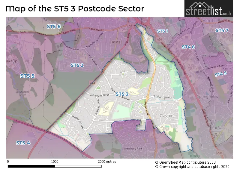
The ST5 3 Postcode shares a border with ST5 1 (NEWCASTLE), ST4 6 (STOKE-ON-TRENT), ST5 2 (NEWCASTLE) and ST5 4 (NEWCASTLE, Butterton, Acton).
The sector is within the post town of NEWCASTLE.
ST5 3 is a postcode sector within the ST5 postcode district which is within the ST Stoke-on-Trent postcode area.
The Royal Mail delivery office for the ST5 3 postal sector is the Newcastle Under Lyme Delivery Office.
The area of the ST5 3 postcode sector is 1.41 square miles which is 3.65 square kilometres or 903.12 square acres.
The ST5 3 postcode sector is crossed by the M6 motorway.

Map of the ST5 3 Postcode Sector
Explore the ST5 3 postcode sector by using our free interactive map.
| S | T | 5 | - | 3 | X | X |
| S | T | 5 | Space | 3 | Letter | Letter |
Official List of Streets
NEWCASTLE (129 Streets)
Unofficial Streets or Alternative Spellings
NEWCASTLE
CAMBRIDGE COURT EDWARD AVENUE FRIARSWOOD ROAD HATRELL STREET PRIORY ROAD SEABRIDGE ROAD SNEYD AVENUE BEAUMONT COURT BROOKLANE BRIDGE DELLBROOK COURT ELMHURST FAIROAK FRIARS WALK HARROWBY COURT HARTWELL HIGHFIELD COURT LILLESHALL AVENUE POOL DAM BRANCH RIVERSMEAD RUSHTON SAINT HELIER CLOSE SYEYD ROUNDABOUT THE PARKWAY THE SQUARE WAVENEY COURTNEWCASTLE,
CLAYTON LANEButterton
WHITMORE ROADWeather Forecast for ST5 3
Press Button to Show Forecast for Clayton (Staffordshire)
| Time Period | Icon | Description | Temperature | Rain Probability | Wind |
|---|---|---|---|---|---|
| 00:00 to 03:00 | Cloudy | 15.0°C (feels like 13.0°C) | 3.00% | ESE 9 mph | |
| 03:00 to 06:00 | Partly cloudy (night) | 13.0°C (feels like 11.0°C) | 1.00% | ESE 7 mph | |
| 06:00 to 09:00 | Cloudy | 13.0°C (feels like 12.0°C) | 4.00% | ESE 9 mph | |
| 09:00 to 12:00 | Cloudy | 17.0°C (feels like 15.0°C) | 3.00% | ESE 11 mph | |
| 12:00 to 15:00 | Cloudy | 21.0°C (feels like 18.0°C) | 12.00% | ESE 11 mph | |
| 15:00 to 18:00 | Light rain shower (day) | 22.0°C (feels like 20.0°C) | 33.00% | SE 11 mph | |
| 18:00 to 21:00 | Light rain shower (day) | 20.0°C (feels like 19.0°C) | 36.00% | SSE 7 mph | |
| 21:00 to 00:00 | Cloudy | 17.0°C (feels like 16.0°C) | 32.00% | SE 7 mph |
Press Button to Show Forecast for Clayton (Staffordshire)
| Time Period | Icon | Description | Temperature | Rain Probability | Wind |
|---|---|---|---|---|---|
| 00:00 to 03:00 | Clear night | 15.0°C (feels like 14.0°C) | 8.00% | SSE 7 mph | |
| 03:00 to 06:00 | Partly cloudy (night) | 13.0°C (feels like 12.0°C) | 6.00% | S 7 mph | |
| 06:00 to 09:00 | Cloudy | 13.0°C (feels like 11.0°C) | 10.00% | S 7 mph | |
| 09:00 to 12:00 | Cloudy | 14.0°C (feels like 12.0°C) | 14.00% | SSE 11 mph | |
| 12:00 to 15:00 | Cloudy | 16.0°C (feels like 13.0°C) | 14.00% | SSE 13 mph | |
| 15:00 to 18:00 | Cloudy | 16.0°C (feels like 13.0°C) | 24.00% | SSE 16 mph | |
| 18:00 to 21:00 | Heavy rain | 14.0°C (feels like 12.0°C) | 77.00% | SE 13 mph | |
| 21:00 to 00:00 | Heavy rain | 13.0°C (feels like 11.0°C) | 84.00% | SE 13 mph |
Press Button to Show Forecast for Clayton (Staffordshire)
| Time Period | Icon | Description | Temperature | Rain Probability | Wind |
|---|---|---|---|---|---|
| 00:00 to 03:00 | Heavy rain | 13.0°C (feels like 11.0°C) | 81.00% | SE 11 mph | |
| 03:00 to 06:00 | Light rain | 12.0°C (feels like 10.0°C) | 58.00% | SSE 9 mph | |
| 06:00 to 09:00 | Light rain | 12.0°C (feels like 10.0°C) | 54.00% | SE 9 mph | |
| 09:00 to 12:00 | Light rain shower (day) | 13.0°C (feels like 11.0°C) | 43.00% | SSE 11 mph | |
| 12:00 to 15:00 | Light rain shower (day) | 15.0°C (feels like 13.0°C) | 44.00% | SSE 13 mph | |
| 15:00 to 18:00 | Light rain shower (day) | 16.0°C (feels like 13.0°C) | 42.00% | SSE 13 mph | |
| 18:00 to 21:00 | Light rain shower (day) | 15.0°C (feels like 13.0°C) | 40.00% | SSE 11 mph | |
| 21:00 to 00:00 | Partly cloudy (night) | 12.0°C (feels like 11.0°C) | 7.00% | SSE 11 mph |
Press Button to Show Forecast for Clayton (Staffordshire)
| Time Period | Icon | Description | Temperature | Rain Probability | Wind |
|---|---|---|---|---|---|
| 00:00 to 03:00 | Partly cloudy (night) | 11.0°C (feels like 9.0°C) | 7.00% | SSE 9 mph | |
| 03:00 to 06:00 | Cloudy | 10.0°C (feels like 8.0°C) | 10.00% | SE 9 mph | |
| 06:00 to 09:00 | Cloudy | 11.0°C (feels like 9.0°C) | 10.00% | SE 11 mph | |
| 09:00 to 12:00 | Light rain shower (day) | 13.0°C (feels like 11.0°C) | 33.00% | SSE 13 mph | |
| 12:00 to 15:00 | Light rain shower (day) | 15.0°C (feels like 13.0°C) | 39.00% | SSE 13 mph | |
| 15:00 to 18:00 | Light rain shower (day) | 15.0°C (feels like 13.0°C) | 41.00% | S 11 mph | |
| 18:00 to 21:00 | Light rain shower (day) | 15.0°C (feels like 13.0°C) | 37.00% | S 9 mph | |
| 21:00 to 00:00 | Clear night | 12.0°C (feels like 11.0°C) | 6.00% | S 7 mph |
Schools and Places of Education Within the ST5 3 Postcode Sector
Clayton Hall Academy
Academy converter
Clayton Lane, Newcastle-under-Lyme, Staffordshire, ST5 3DN
Head: Mrs Catherine Reid
Ofsted Rating: Requires improvement
Inspection: 2021-09-22 (963 days ago)
Website: Visit Clayton Hall Academy Website
Phone: 01782367650
Number of Pupils: 832
Seabridge Primary School
Academy converter
Roe Lane, Newcastle-Under-Lyme, Staffordshire, ST5 3PJ
Head: Ms Sally Sanders
Ofsted Rating: Good
Inspection: 2021-11-18 (906 days ago)
Website: Visit Seabridge Primary School Website
Phone: 01782432530
Number of Pupils: 440
House Prices in the ST5 3 Postcode Sector
| Type of Property | 2018 Average | 2018 Sales | 2017 Average | 2017 Sales | 2016 Average | 2016 Sales | 2015 Average | 2015 Sales |
|---|---|---|---|---|---|---|---|---|
| Detached | £335,615 | 34 | £349,749 | 53 | £340,583 | 54 | £309,258 | 59 |
| Semi-Detached | £198,881 | 64 | £197,002 | 84 | £182,455 | 64 | £172,600 | 74 |
| Terraced | £145,879 | 19 | £142,814 | 11 | £127,184 | 19 | £134,773 | 11 |
| Flats | £87,500 | 4 | £91,938 | 8 | £89,550 | 9 | £100,000 | 2 |
Important Postcodes ST5 3 in the Postcode Sector
ST5 3DN is the postcode for GYM BLOCK, Clayton Hall Academy, Clayton Lane, CDT AND ART BLOCK, Clayton Hall Academy, Clayton Lane, Clayton Hall Academy, Clayton Lane, SPORTS HALL, Clayton Hall Academy, Clayton Lane, and CLAYTON HALL ACADEMY, CLAYTON LANE, NEWCASTLE UNDER LYME
ST5 3HP is the postcode for Kingsbridge Medical Practice, Kingsbridge Avenue
ST5 3NR is the postcode for Staffordshire County Council, Clayton Library
ST5 3PJ is the postcode for Seabridge Primary School, Roe Lane, SEABRIDGE PRIMARY SCHOOL, ROE LANE, NEWCASTLE UNDER LYME, Roe Lane Sports Pavilion, Roe Lane, Seabridge Community Education Centre, Roe Lane, and Seabridge County Junior & Infants School, Roe Lane
ST5 3QE is the postcode for Langdale Junior School, Langdale Road
ST5 3TF is the postcode for Lyme Valley Medical Centre, Lyme Valley Road
| The ST5 3 Sector is within these Local Authorities |
|
|---|---|
| The ST5 3 Sector is within these Counties |
|
| The ST5 3 Sector is within these Water Company Areas |
|