The W11 1 postcode sector is within the county of Greater London.
Did you know? According to the 2021 Census, the W11 1 postcode sector is home to a bustling 9,514 residents!
Given that each sector allows for 400 unique postcode combinations. Letters C, I, K, M, O and V are not allowed in the last two letters of a postcode. With 161 postcodes already in use, this leaves 239 units available.
The W11 1 postal code covers the settlement of LONDON .
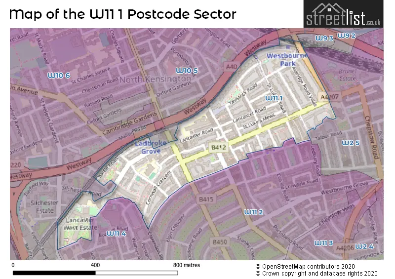
The W11 1 Postcode shares a border with W2 5 (LONDON ), W9 3 (LONDON ), W10 6 (LONDON ), W11 2 (LONDON ), W11 4 (LONDON ) and W10 5 (LONDON ).
The sector is within the post town of LONDON.
W11 1 is a postcode sector within the W11 postcode district which is within the W West London postcode area.
The Royal Mail delivery office for the W11 1 postal sector is the Notting Hill Sdelivery Office.
The area of the W11 1 postcode sector is 0.17 square miles which is 0.43 square kilometres or 107.13 square acres.

Map of the W11 1 Postcode Sector
Explore the W11 1 postcode sector by using our free interactive map.
| W | 1 | 1 | - | 1 | X | X |
| W | 1 | 1 | Space | 1 | Letter | Letter |
Official List of Streets
Kensington and Chelsea (51 Streets)
Westminster (9 Streets)
Unofficial Streets or Alternative Spellings
Kensington and Chelsea
BRAMLEY ROAD CODRINGTON MEWS GRENFELL ROAD SILCHESTER ROAD WHITCHURCH ROAD COLVILLE HOUSES STATION WALK TAVISTOCK MEWSWeather Forecast for W11 1
Press Button to Show Forecast for Holland House Youth Hostel
| Time Period | Icon | Description | Temperature | Rain Probability | Wind |
|---|---|---|---|---|---|
| 03:00 to 06:00 | Cloudy | 6.0°C (feels like 4.0°C) | 5.00% | NE 7 mph | |
| 06:00 to 09:00 | Cloudy | 5.0°C (feels like 3.0°C) | 5.00% | NE 7 mph | |
| 09:00 to 12:00 | Cloudy | 8.0°C (feels like 6.0°C) | 4.00% | ENE 7 mph | |
| 12:00 to 15:00 | Cloudy | 10.0°C (feels like 9.0°C) | 10.00% | ENE 7 mph | |
| 15:00 to 18:00 | Cloudy | 11.0°C (feels like 10.0°C) | 13.00% | ENE 7 mph | |
| 18:00 to 21:00 | Cloudy | 10.0°C (feels like 9.0°C) | 13.00% | NE 7 mph | |
| 21:00 to 00:00 | Cloudy | 8.0°C (feels like 5.0°C) | 11.00% | E 7 mph |
Press Button to Show Forecast for Holland House Youth Hostel
| Time Period | Icon | Description | Temperature | Rain Probability | Wind |
|---|---|---|---|---|---|
| 00:00 to 03:00 | Cloudy | 6.0°C (feels like 4.0°C) | 17.00% | ENE 7 mph | |
| 03:00 to 06:00 | Cloudy | 5.0°C (feels like 3.0°C) | 18.00% | NE 7 mph | |
| 06:00 to 09:00 | Overcast | 6.0°C (feels like 3.0°C) | 24.00% | ENE 7 mph | |
| 09:00 to 12:00 | Cloudy | 10.0°C (feels like 7.0°C) | 15.00% | ENE 9 mph | |
| 12:00 to 15:00 | Overcast | 12.0°C (feels like 10.0°C) | 17.00% | E 9 mph | |
| 15:00 to 18:00 | Light rain | 13.0°C (feels like 10.0°C) | 52.00% | E 11 mph | |
| 18:00 to 21:00 | Light rain | 11.0°C (feels like 9.0°C) | 54.00% | ENE 9 mph | |
| 21:00 to 00:00 | Light rain | 10.0°C (feels like 7.0°C) | 54.00% | NE 11 mph |
Press Button to Show Forecast for Holland House Youth Hostel
| Time Period | Icon | Description | Temperature | Rain Probability | Wind |
|---|---|---|---|---|---|
| 00:00 to 03:00 | Heavy rain | 9.0°C (feels like 7.0°C) | 74.00% | NE 9 mph | |
| 03:00 to 06:00 | Light rain shower (night) | 10.0°C (feels like 8.0°C) | 45.00% | ESE 9 mph | |
| 06:00 to 09:00 | Light rain | 10.0°C (feels like 8.0°C) | 52.00% | SE 7 mph | |
| 09:00 to 12:00 | Heavy rain shower (day) | 11.0°C (feels like 9.0°C) | 61.00% | SE 9 mph | |
| 12:00 to 15:00 | Heavy rain shower (day) | 12.0°C (feels like 11.0°C) | 61.00% | S 9 mph | |
| 15:00 to 18:00 | Light rain shower (day) | 14.0°C (feels like 12.0°C) | 37.00% | SSW 11 mph | |
| 18:00 to 21:00 | Partly cloudy (day) | 12.0°C (feels like 10.0°C) | 15.00% | SW 11 mph | |
| 21:00 to 00:00 | Partly cloudy (night) | 10.0°C (feels like 9.0°C) | 8.00% | SW 7 mph |
Schools and Places of Education Within the W11 1 Postcode Sector
Chepstow House School
Other independent school
108a Lancaster Road, London, , W11 1QS
Head: Mrs Angela Barr
Ofsted Rating: Outstanding
Inspection: 2018-01-11 (2297 days ago)
Website: Visit Chepstow House School Website
Phone: 02072430243
Number of Pupils: 397
Thomas Jones Primary School
Community school
St Mark's Road, London, , W11 1RQ
Head: Mr David Sellens
Ofsted Rating: Outstanding
Inspection: 2023-10-18 (191 days ago)
Website: Visit Thomas Jones Primary School Website
Phone: 02077271423
Number of Pupils: 236
House Prices in the W11 1 Postcode Sector
| Type of Property | 2018 Average | 2018 Sales | 2017 Average | 2017 Sales | 2016 Average | 2016 Sales | 2015 Average | 2015 Sales |
|---|---|---|---|---|---|---|---|---|
| Detached | £0 | 0 | £0 | 0 | £0 | 0 | £0 | 0 |
| Semi-Detached | £0 | 0 | £0 | 0 | £0 | 0 | £0 | 0 |
| Terraced | £2,093,286 | 14 | £1,268,750 | 4 | £3,025,500 | 10 | £2,339,367 | 6 |
| Flats | £757,401 | 51 | £806,808 | 81 | £761,878 | 65 | £670,139 | 95 |
Important Postcodes W11 1 in the Postcode Sector
W11 1BA is the postcode for Westmead Elderly Resource Centre, 4 Tavistock Road
W11 1EG is the postcode for CLARE GARDENS CHILDREN'S CENTRE, 349, Westbourne Park Road
W11 1PA is the postcode for Colville Health Centre, 52 Kensington Park Road, Colville Health Centre, 51 Kensington Park Road, and Colville Health Cenre, 51 Kensington Park Road
W11 1PZ is the postcode for Royal Borough of Kensington & Chelsea, North Kensington Public Library, 108 Ladbroke Grove
W11 1QF is the postcode for Unit C Royalty Studios, 105, Lancaster Road
W11 1QG is the postcode for Parkside Clinic, 63 Lancaster Road
W11 1QS is the postcode for School Improvement Team, Isaac Newton Centre 108a, Lancaster Road, and Chepstow House School, 108a Lancaster Road
W11 1RG is the postcode for GROVE AND SCOPE DAY CENTRE, Scope, 1-9 St. Marks Road
W11 1RQ is the postcode for Thomas Jones Primary School, St Mark's Road, and Thomas Jones Primary School, St. Marks Road
| The W11 1 Sector is within these Local Authorities |
|
|---|---|
| The W11 1 Sector is within these Counties |
|
| The W11 1 Sector is within these Water Company Areas |
|