The W11 2 postcode sector is within the county of Greater London.
Did you know? According to the 2021 Census, the W11 2 postcode sector is home to a bustling 6,454 residents!
Given that each sector allows for 400 unique postcode combinations. Letters C, I, K, M, O and V are not allowed in the last two letters of a postcode. With 167 postcodes already in use, this leaves 233 units available.
The W11 2 postal code covers the settlement of LONDON .
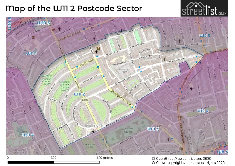
The W11 2 Postcode shares a border with W2 4 (LONDON ), W2 5 (LONDON ), W11 1 (LONDON ), W11 4 (LONDON ) and W11 3 (LONDON ).
The sector is within the post town of LONDON.
W11 2 is a postcode sector within the W11 postcode district which is within the W West London postcode area.
The Royal Mail delivery office for the W11 2 postal sector is the Notting Hill Sdelivery Office.
The area of the W11 2 postcode sector is 0.18 square miles which is 0.46 square kilometres or 113.49 square acres.

Map of the W11 2 Postcode Sector
Explore the W11 2 postcode sector by using our free interactive map.
| W | 1 | 1 | - | 2 | X | X |
| W | 1 | 1 | Space | 2 | Letter | Letter |
Official List of Streets
Kensington and Chelsea (40 Streets)
Unofficial Streets or Alternative Spellings
Kensington and Chelsea
CLARENDON CROSS CLYDESDALE ROAD PEMBRIDGE CRESCENT PORTLAND ROAD POWIS GARDENS POWIS MEWS POWIS TERRACE ROSEHART MEWS BRUNSWICK FLATS BRUNSWICK FLATS, PRIVATE RESIDENTIAL, NOT A THROUGHWAY COLVILLE HOUSES PENTAGRAM YARD PORTOBELLO COURT ST MARKS ROAD WEST HILL COURTWestminster
ARTESIAN ROADWeather Forecast for W11 2
Press Button to Show Forecast for Holland House Youth Hostel
| Time Period | Icon | Description | Temperature | Rain Probability | Wind |
|---|---|---|---|---|---|
| 03:00 to 06:00 | Partly cloudy (night) | 15.0°C (feels like 14.0°C) | 1.00% | E 7 mph | |
| 06:00 to 09:00 | Cloudy | 15.0°C (feels like 15.0°C) | 4.00% | ENE 7 mph | |
| 09:00 to 12:00 | Cloudy | 19.0°C (feels like 18.0°C) | 4.00% | E 7 mph | |
| 12:00 to 15:00 | Partly cloudy (day) | 24.0°C (feels like 22.0°C) | 2.00% | ESE 9 mph | |
| 15:00 to 18:00 | Cloudy | 25.0°C (feels like 23.0°C) | 7.00% | SE 9 mph | |
| 18:00 to 21:00 | Cloudy | 23.0°C (feels like 22.0°C) | 8.00% | SSE 7 mph | |
| 21:00 to 00:00 | Cloudy | 18.0°C (feels like 17.0°C) | 9.00% | SSW 7 mph |
Press Button to Show Forecast for Holland House Youth Hostel
| Time Period | Icon | Description | Temperature | Rain Probability | Wind |
|---|---|---|---|---|---|
| 00:00 to 03:00 | Cloudy | 15.0°C (feels like 15.0°C) | 16.00% | SSW 7 mph | |
| 03:00 to 06:00 | Partly cloudy (night) | 14.0°C (feels like 13.0°C) | 7.00% | S 7 mph | |
| 06:00 to 09:00 | Overcast | 14.0°C (feels like 12.0°C) | 12.00% | SSW 9 mph | |
| 09:00 to 12:00 | Overcast | 16.0°C (feels like 14.0°C) | 12.00% | SSW 11 mph | |
| 12:00 to 15:00 | Cloudy | 17.0°C (feels like 15.0°C) | 10.00% | S 13 mph | |
| 15:00 to 18:00 | Cloudy | 18.0°C (feels like 15.0°C) | 17.00% | S 13 mph | |
| 18:00 to 21:00 | Light rain | 17.0°C (feels like 15.0°C) | 54.00% | SSE 11 mph | |
| 21:00 to 00:00 | Heavy rain | 15.0°C (feels like 14.0°C) | 80.00% | SSE 11 mph |
Press Button to Show Forecast for Holland House Youth Hostel
| Time Period | Icon | Description | Temperature | Rain Probability | Wind |
|---|---|---|---|---|---|
| 00:00 to 03:00 | Heavy rain | 15.0°C (feels like 13.0°C) | 78.00% | SSE 9 mph | |
| 03:00 to 06:00 | Heavy rain | 14.0°C (feels like 13.0°C) | 76.00% | SSE 7 mph | |
| 06:00 to 09:00 | Light rain | 13.0°C (feels like 12.0°C) | 58.00% | SSE 7 mph | |
| 09:00 to 12:00 | Light rain | 15.0°C (feels like 13.0°C) | 56.00% | S 11 mph | |
| 12:00 to 15:00 | Light rain shower (day) | 17.0°C (feels like 14.0°C) | 39.00% | S 13 mph | |
| 15:00 to 18:00 | Light rain shower (day) | 17.0°C (feels like 14.0°C) | 33.00% | S 13 mph | |
| 18:00 to 21:00 | Partly cloudy (day) | 16.0°C (feels like 14.0°C) | 11.00% | S 11 mph | |
| 21:00 to 00:00 | Clear night | 14.0°C (feels like 13.0°C) | 9.00% | SSE 9 mph |
Press Button to Show Forecast for Holland House Youth Hostel
| Time Period | Icon | Description | Temperature | Rain Probability | Wind |
|---|---|---|---|---|---|
| 00:00 to 03:00 | Partly cloudy (night) | 13.0°C (feels like 12.0°C) | 5.00% | S 9 mph | |
| 03:00 to 06:00 | Cloudy | 12.0°C (feels like 11.0°C) | 7.00% | S 7 mph | |
| 06:00 to 09:00 | Partly cloudy (day) | 12.0°C (feels like 11.0°C) | 6.00% | S 9 mph | |
| 09:00 to 12:00 | Partly cloudy (day) | 15.0°C (feels like 12.0°C) | 9.00% | S 11 mph | |
| 12:00 to 15:00 | Light rain shower (day) | 16.0°C (feels like 14.0°C) | 32.00% | S 13 mph | |
| 15:00 to 18:00 | Partly cloudy (day) | 17.0°C (feels like 15.0°C) | 7.00% | S 11 mph | |
| 18:00 to 21:00 | Sunny day | 17.0°C (feels like 15.0°C) | 8.00% | S 9 mph | |
| 21:00 to 00:00 | Clear night | 14.0°C (feels like 13.0°C) | 6.00% | S 7 mph |
Schools and Places of Education Within the W11 2 Postcode Sector
Colville Primary School
Community school
Lonsdale Road, London, , W11 2DF
Head: Mr Jagdeep Birdi
Ofsted Rating: Outstanding
Inspection: 2019-02-13 (1915 days ago)
Website: Visit Colville Primary School Website
Phone: 02072296540
Number of Pupils: 464
House Prices in the W11 2 Postcode Sector
| Type of Property | 2018 Average | 2018 Sales | 2017 Average | 2017 Sales | 2016 Average | 2016 Sales | 2015 Average | 2015 Sales |
|---|---|---|---|---|---|---|---|---|
| Detached | £0 | 0 | £0 | 0 | £8,525,000 | 2 | £0 | 0 |
| Semi-Detached | £5,000,000 | 2 | £0 | 0 | £10,827,000 | 5 | £12,250,000 | 1 |
| Terraced | £4,893,947 | 19 | £6,466,634 | 11 | £6,503,331 | 23 | £3,766,691 | 19 |
| Flats | £1,449,948 | 62 | £1,131,216 | 50 | £1,267,765 | 64 | £1,128,598 | 73 |
Important Postcodes W11 2 in the Postcode Sector
W11 2DF is the postcode for Colville Primary School, Lonsdale Road
W11 2RQ is the postcode for Royal Mail, Notting Hill Delivery Office, 222 Westbourne Grove
W11 2SE is the postcode for Westbourne Grove Medical Centre, 241 Westbourne Grove
| The W11 2 Sector is within these Local Authorities |
|
|---|---|
| The W11 2 Sector is within these Counties |
|
| The W11 2 Sector is within these Water Company Areas |
|