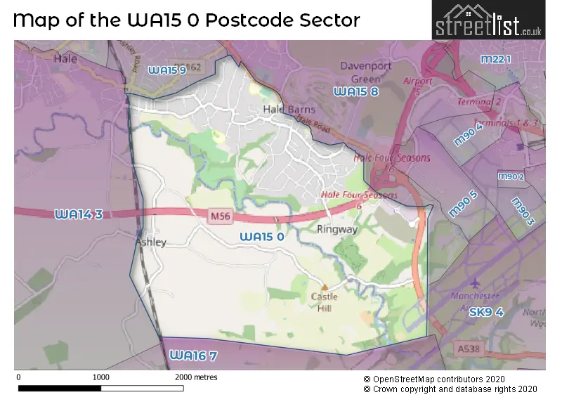
The WA15 0 postcode sector stands on the Cheshire and Greater Manchester border.
Did you know? According to the 2021 Census, the WA15 0 postcode sector is home to a bustling 4,617 residents!
Given that each sector allows for 400 unique postcode combinations. Letters C, I, K, M, O and V are not allowed in the last two letters of a postcode. With 187 postcodes already in use, this leaves 213 units available.
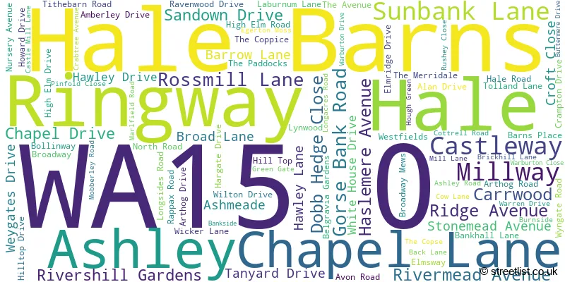
The largest settlement in the WA15 0 postal code is Hale Barns followed by Hale, and Ashley.
The WA15 0 Postcode shares a border with WA14 3 (Bowdon, Hale, Ashley), SK9 4 (WILMSLOW, Styal), WA15 8 (Hale, ALTRINCHAM, Hale Barns), WA15 9 (Hale, ALTRINCHAM) and WA16 7 (Mobberley, Marthall, KNUTSFORD).
The sector is within the post town of ALTRINCHAM.
WA15 0 is a postcode sector within the WA15 postcode district which is within the WA Warrington postcode area.
The Royal Mail delivery office for the WA15 0 postal sector is the Lymm Scale Payment Delivery Office and Altrincham Delivery Office.
The area of the WA15 0 postcode sector is 3.64 square miles which is 9.43 square kilometres or 2,331.29 square acres.
The WA15 0 postcode sector is crossed by the M56 motorway.
Waterways within the WA15 0 postcode sector include the River Bollin.

Map of the WA15 0 Postcode Sector
Explore the WA15 0 postcode sector by using our free interactive map.
| W | A | 1 | 5 | - | 0 | X | X |
| W | A | 1 | 5 | Space | 0 | Letter | Letter |
Official List of Streets
Hale (25 Streets)
Hale Barns (49 Streets)
Ashley (9 Streets)
Unofficial Streets or Alternative Spellings
Weather Forecast for WA15 0
Press Button to Show Forecast for Warburton Green
| Time Period | Icon | Description | Temperature | Rain Probability | Wind |
|---|---|---|---|---|---|
| 21:00 to 00:00 | Cloudy | 6.0°C (feels like 4.0°C) | 4.00% | ENE 7 mph |
Press Button to Show Forecast for Warburton Green
| Time Period | Icon | Description | Temperature | Rain Probability | Wind |
|---|---|---|---|---|---|
| 00:00 to 03:00 | Cloudy | 5.0°C (feels like 3.0°C) | 5.00% | ENE 7 mph | |
| 03:00 to 06:00 | Partly cloudy (night) | 5.0°C (feels like 2.0°C) | 4.00% | NE 7 mph | |
| 06:00 to 09:00 | Cloudy | 5.0°C (feels like 2.0°C) | 5.00% | NE 7 mph | |
| 09:00 to 12:00 | Cloudy | 8.0°C (feels like 5.0°C) | 6.00% | ENE 9 mph | |
| 12:00 to 15:00 | Overcast | 9.0°C (feels like 7.0°C) | 15.00% | ENE 9 mph | |
| 15:00 to 18:00 | Overcast | 9.0°C (feels like 7.0°C) | 16.00% | ENE 9 mph | |
| 18:00 to 21:00 | Cloudy | 9.0°C (feels like 7.0°C) | 10.00% | ENE 9 mph | |
| 21:00 to 00:00 | Cloudy | 7.0°C (feels like 5.0°C) | 4.00% | NE 9 mph |
Press Button to Show Forecast for Warburton Green
| Time Period | Icon | Description | Temperature | Rain Probability | Wind |
|---|---|---|---|---|---|
| 00:00 to 03:00 | Cloudy | 6.0°C (feels like 3.0°C) | 4.00% | NE 7 mph | |
| 03:00 to 06:00 | Cloudy | 5.0°C (feels like 3.0°C) | 7.00% | NNE 9 mph | |
| 06:00 to 09:00 | Cloudy | 6.0°C (feels like 3.0°C) | 14.00% | N 9 mph | |
| 09:00 to 12:00 | Light rain | 7.0°C (feels like 5.0°C) | 47.00% | NNW 7 mph | |
| 12:00 to 15:00 | Cloudy | 9.0°C (feels like 7.0°C) | 16.00% | NW 9 mph | |
| 15:00 to 18:00 | Cloudy | 10.0°C (feels like 8.0°C) | 13.00% | WNW 11 mph | |
| 18:00 to 21:00 | Sunny day | 10.0°C (feels like 8.0°C) | 4.00% | W 9 mph | |
| 21:00 to 00:00 | Clear night | 7.0°C (feels like 5.0°C) | 2.00% | SW 7 mph |
Press Button to Show Forecast for Warburton Green
| Time Period | Icon | Description | Temperature | Rain Probability | Wind |
|---|---|---|---|---|---|
| 00:00 to 03:00 | Clear night | 6.0°C (feels like 3.0°C) | 2.00% | SSW 7 mph | |
| 03:00 to 06:00 | Clear night | 5.0°C (feels like 2.0°C) | 1.00% | SSE 7 mph | |
| 06:00 to 09:00 | Sunny day | 6.0°C (feels like 3.0°C) | 2.00% | SSE 9 mph | |
| 09:00 to 12:00 | Partly cloudy (day) | 10.0°C (feels like 8.0°C) | 2.00% | S 11 mph | |
| 12:00 to 15:00 | Overcast | 13.0°C (feels like 10.0°C) | 11.00% | S 13 mph | |
| 15:00 to 18:00 | Cloudy | 14.0°C (feels like 11.0°C) | 7.00% | S 13 mph | |
| 18:00 to 21:00 | Cloudy | 13.0°C (feels like 11.0°C) | 8.00% | SSE 11 mph | |
| 21:00 to 00:00 | Partly cloudy (night) | 11.0°C (feels like 9.0°C) | 3.00% | SSE 9 mph |
Press Button to Show Forecast for Warburton Green
| Time Period | Icon | Description | Temperature | Rain Probability | Wind |
|---|---|---|---|---|---|
| 00:00 to 03:00 | Partly cloudy (night) | 9.0°C (feels like 7.0°C) | 3.00% | SE 9 mph | |
| 03:00 to 06:00 | Partly cloudy (night) | 8.0°C (feels like 6.0°C) | 2.00% | SE 9 mph | |
| 06:00 to 09:00 | Sunny day | 9.0°C (feels like 7.0°C) | 2.00% | ESE 9 mph | |
| 09:00 to 12:00 | Partly cloudy (day) | 13.0°C (feels like 10.0°C) | 4.00% | ESE 13 mph | |
| 12:00 to 15:00 | Partly cloudy (day) | 15.0°C (feels like 12.0°C) | 7.00% | SE 13 mph | |
| 15:00 to 18:00 | Cloudy | 16.0°C (feels like 13.0°C) | 12.00% | SE 11 mph | |
| 18:00 to 21:00 | Partly cloudy (day) | 15.0°C (feels like 13.0°C) | 11.00% | ESE 9 mph | |
| 21:00 to 00:00 | Partly cloudy (night) | 12.0°C (feels like 11.0°C) | 4.00% | ESE 9 mph |
Schools and Places of Education Within the WA15 0 Postcode Sector
Elmridge Primary School
Academy converter
Wilton Drive, Altrincham, Cheshire, WA15 0JF
Head: Ms Rebecca Bolton
Ofsted Rating: Good
Inspection: 2023-11-29 (149 days ago)
Website: Visit Elmridge Primary School Website
Phone: 01619804941
Number of Pupils: 234
Saint Ambrose College
Academy converter
Hale Road, Altrincham, Cheshire, WA15 0HE
Head: Dermot Rainey
Ofsted Rating: Good
Inspection: 2020-02-19 (1528 days ago)
Website: Visit Saint Ambrose College Website
Phone: 01619802711
Number of Pupils: 1082
House Prices in the WA15 0 Postcode Sector
| Type of Property | 2018 Average | 2018 Sales | 2017 Average | 2017 Sales | 2016 Average | 2016 Sales | 2015 Average | 2015 Sales |
|---|---|---|---|---|---|---|---|---|
| Detached | £991,260 | 50 | £1,190,975 | 59 | £1,163,763 | 53 | £888,538 | 62 |
| Semi-Detached | £638,125 | 12 | £532,038 | 13 | £573,765 | 13 | £415,763 | 11 |
| Terraced | £418,082 | 11 | £417,400 | 5 | £335,250 | 6 | £328,639 | 9 |
| Flats | £905,667 | 3 | £0 | 0 | £320,000 | 1 | £490,000 | 2 |
Important Postcodes WA15 0 in the Postcode Sector
WA15 0HE is the postcode for St. Ambrose College, Hale Road, SAINT AMBROSE COLLEGE, Hale Road, Hale Barns, and St. Ambrose College, Wicker Lane
WA15 0JF is the postcode for Elmridge Primary School, Wilton Drive
| The WA15 0 Sector is within these Local Authorities |
|
|---|---|
| The WA15 0 Sector is within these Counties |
|
| The WA15 0 Sector is within these Water Company Areas |
|