The WA15 9 postcode sector is within the county of Greater Manchester.
Did you know? According to the 2021 Census, the WA15 9 postcode sector is home to a bustling 5,959 residents!
Given that each sector allows for 400 unique postcode combinations. Letters C, I, K, M, O and V are not allowed in the last two letters of a postcode. With 190 postcodes already in use, this leaves 210 units available.
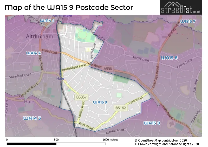
The largest settlements in the WA15 9 postal code are Hale and ALTRINCHAM.
The WA15 9 Postcode shares a border with WA14 1 (ALTRINCHAM, Timperley), WA14 2 (ALTRINCHAM, Bowdon, Hale), WA14 3 (Bowdon, Hale, Ashley), WA15 0 (Hale Barns, Hale, Ashley) and WA15 8 (Hale, ALTRINCHAM, Hale Barns).
The sector is within the post town of ALTRINCHAM.
WA15 9 is a postcode sector within the WA15 postcode district which is within the WA Warrington postcode area.
The Royal Mail delivery office for the WA15 9 postal sector is the Altrincham Delivery Office.
The area of the WA15 9 postcode sector is 0.58 square miles which is 1.51 square kilometres or 373.61 square acres.

Map of the WA15 9 Postcode Sector
Explore the WA15 9 postcode sector by using our free interactive map.
| W | A | 1 | 5 | - | 9 | X | X |
| W | A | 1 | 5 | Space | 9 | Letter | Letter |
Official List of Streets
Hale (66 Streets)
ALTRINCHAM (13 Streets)
Unofficial Streets or Alternative Spellings
Hale
ACACIA AVENUE ARTHOG ROAD AVON ROAD HARGATE DRIVE LABURNUM LANE MOSS LANE NURSERY AVENUE TOLLAND LANE HEATHER ROAD HILL TOP DRIVE MASSE ROAD ST ANDREWS COURTALTRINCHAM
SCOTT DRIVE URBAN AVENUE WELMAN WAYAshley
ASHLEY ROADHale Barns
HALE ROADWeather Forecast for WA15 9
Press Button to Show Forecast for Hale
| Time Period | Icon | Description | Temperature | Rain Probability | Wind |
|---|---|---|---|---|---|
| 18:00 to 21:00 | Cloudy | 8.0°C (feels like 7.0°C) | 7.00% | E 7 mph | |
| 21:00 to 00:00 | Cloudy | 7.0°C (feels like 5.0°C) | 4.00% | ENE 7 mph |
Press Button to Show Forecast for Hale
| Time Period | Icon | Description | Temperature | Rain Probability | Wind |
|---|---|---|---|---|---|
| 00:00 to 03:00 | Cloudy | 6.0°C (feels like 4.0°C) | 5.00% | ENE 4 mph | |
| 03:00 to 06:00 | Partly cloudy (night) | 5.0°C (feels like 3.0°C) | 4.00% | NE 4 mph | |
| 06:00 to 09:00 | Cloudy | 5.0°C (feels like 2.0°C) | 5.00% | NE 7 mph | |
| 09:00 to 12:00 | Cloudy | 8.0°C (feels like 6.0°C) | 7.00% | ENE 9 mph | |
| 12:00 to 15:00 | Overcast | 10.0°C (feels like 8.0°C) | 15.00% | ENE 9 mph | |
| 15:00 to 18:00 | Overcast | 10.0°C (feels like 7.0°C) | 15.00% | ENE 9 mph | |
| 18:00 to 21:00 | Cloudy | 9.0°C (feels like 7.0°C) | 9.00% | ENE 9 mph | |
| 21:00 to 00:00 | Cloudy | 7.0°C (feels like 5.0°C) | 4.00% | NE 7 mph |
Press Button to Show Forecast for Hale
| Time Period | Icon | Description | Temperature | Rain Probability | Wind |
|---|---|---|---|---|---|
| 00:00 to 03:00 | Cloudy | 6.0°C (feels like 4.0°C) | 4.00% | NE 7 mph | |
| 03:00 to 06:00 | Cloudy | 6.0°C (feels like 3.0°C) | 7.00% | NNE 9 mph | |
| 06:00 to 09:00 | Cloudy | 6.0°C (feels like 3.0°C) | 14.00% | N 9 mph | |
| 09:00 to 12:00 | Light rain | 7.0°C (feels like 5.0°C) | 47.00% | NNW 7 mph | |
| 12:00 to 15:00 | Cloudy | 9.0°C (feels like 7.0°C) | 16.00% | NW 9 mph | |
| 15:00 to 18:00 | Cloudy | 11.0°C (feels like 8.0°C) | 13.00% | WNW 11 mph | |
| 18:00 to 21:00 | Sunny day | 10.0°C (feels like 8.0°C) | 4.00% | W 9 mph | |
| 21:00 to 00:00 | Clear night | 7.0°C (feels like 6.0°C) | 2.00% | SW 7 mph |
Press Button to Show Forecast for Hale
| Time Period | Icon | Description | Temperature | Rain Probability | Wind |
|---|---|---|---|---|---|
| 00:00 to 03:00 | Clear night | 6.0°C (feels like 4.0°C) | 2.00% | S 7 mph | |
| 03:00 to 06:00 | Clear night | 5.0°C (feels like 2.0°C) | 1.00% | SSE 7 mph | |
| 06:00 to 09:00 | Sunny day | 6.0°C (feels like 3.0°C) | 2.00% | SSE 9 mph | |
| 09:00 to 12:00 | Partly cloudy (day) | 11.0°C (feels like 8.0°C) | 2.00% | S 11 mph | |
| 12:00 to 15:00 | Overcast | 13.0°C (feels like 10.0°C) | 11.00% | S 13 mph | |
| 15:00 to 18:00 | Overcast | 14.0°C (feels like 11.0°C) | 10.00% | S 13 mph | |
| 18:00 to 21:00 | Cloudy | 13.0°C (feels like 11.0°C) | 8.00% | SSE 11 mph | |
| 21:00 to 00:00 | Partly cloudy (night) | 11.0°C (feels like 9.0°C) | 3.00% | SSE 9 mph |
Press Button to Show Forecast for Hale
| Time Period | Icon | Description | Temperature | Rain Probability | Wind |
|---|---|---|---|---|---|
| 00:00 to 03:00 | Partly cloudy (night) | 9.0°C (feels like 7.0°C) | 3.00% | SE 9 mph | |
| 03:00 to 06:00 | Partly cloudy (night) | 9.0°C (feels like 6.0°C) | 2.00% | SE 9 mph | |
| 06:00 to 09:00 | Sunny day | 9.0°C (feels like 7.0°C) | 2.00% | ESE 9 mph | |
| 09:00 to 12:00 | Partly cloudy (day) | 13.0°C (feels like 10.0°C) | 4.00% | ESE 13 mph | |
| 12:00 to 15:00 | Partly cloudy (day) | 15.0°C (feels like 12.0°C) | 7.00% | SE 13 mph | |
| 15:00 to 18:00 | Cloudy | 16.0°C (feels like 14.0°C) | 12.00% | SE 11 mph | |
| 18:00 to 21:00 | Partly cloudy (day) | 15.0°C (feels like 13.0°C) | 11.00% | ESE 9 mph | |
| 21:00 to 00:00 | Partly cloudy (night) | 12.0°C (feels like 11.0°C) | 4.00% | ESE 9 mph |
Schools and Places of Education Within the WA15 9 Postcode Sector
Stamford Park Primary School
Community school
Cedar Road, Altrincham, Cheshire, WA15 9JB
Head: Mrs Sarah Price
Ofsted Rating: Good
Inspection: 2020-02-27 (1520 days ago)
Website: Visit Stamford Park Primary School Website
Phone: 01619283608
Number of Pupils: 483
House Prices in the WA15 9 Postcode Sector
| Type of Property | 2018 Average | 2018 Sales | 2017 Average | 2017 Sales | 2016 Average | 2016 Sales | 2015 Average | 2015 Sales |
|---|---|---|---|---|---|---|---|---|
| Detached | £1,158,698 | 23 | £1,185,700 | 30 | £1,148,883 | 30 | £1,040,711 | 19 |
| Semi-Detached | £768,304 | 23 | £691,809 | 23 | £759,697 | 33 | £626,982 | 28 |
| Terraced | £448,873 | 37 | £436,122 | 51 | £421,033 | 63 | £378,408 | 70 |
| Flats | £243,050 | 10 | £271,971 | 16 | £232,571 | 24 | £245,057 | 21 |
Important Postcodes WA15 9 in the Postcode Sector
WA15 9AP is the postcode for 9-11 Broomfield Lane, Hale
WA15 9JB is the postcode for Stamford Park Primary School, Cedar Road, Hale, NURSERY & INFANT SITES, Stamford Park Junior School, Cedar Road, JUNIOR SITE, Stamford Park Junior School, Cedar Road, and Stamford Park Junior School, Cedar Road
| The WA15 9 Sector is within these Local Authorities |
|
|---|---|
| The WA15 9 Sector is within these Counties |
|
| The WA15 9 Sector is within these Water Company Areas |
|