The WS10 9 postcode sector is within the county of West Midlands.
Did you know? According to the 2021 Census, the WS10 9 postcode sector is home to a bustling 14,699 residents!
Given that each sector allows for 400 unique postcode combinations. Letters C, I, K, M, O and V are not allowed in the last two letters of a postcode. With 241 postcodes already in use, this leaves 159 units available.
The WS10 9 postal code covers the settlement of WEDNESBURY.
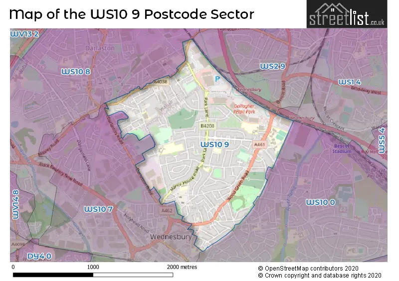
The WS10 9 Postcode shares a border with WS1 4 (WALSALL), WS2 9 (WALSALL, Premier Business Park), WS10 7 (WEDNESBURY, Darlaston), WS10 0 (WEDNESBURY) and WS10 8 (WEDNESBURY, Darlaston, Moxley).
The sector is within the post town of WEDNESBURY.
WS10 9 is a postcode sector within the WS10 postcode district which is within the WS Walsall postcode area.
The Royal Mail delivery office for the WS10 9 postal sector is the Wednesbury Delivery Office.
The area of the WS10 9 postcode sector is 1.18 square miles which is 3.05 square kilometres or 754.87 square acres.

Map of the WS10 9 Postcode Sector
Explore the WS10 9 postcode sector by using our free interactive map.
| W | S | 1 | 0 | - | 9 | X | X |
| W | S | 1 | 0 | Space | 9 | Letter | Letter |
Official List of Streets
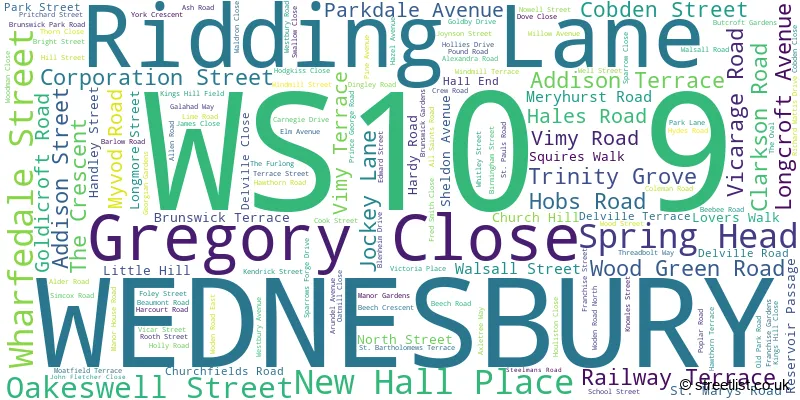
WEDNESBURY (139 Streets)
Unofficial Streets or Alternative Spellings
WEDNESBURY
AVENUE ROAD BILLS STREET BLAKEDON ROAD BULL STREET CENTENARY LANE CRESCENT ROAD DARLASTON ROAD FALLINGS HEATH CLOSE GORDON STREET HEATH ROAD JAMES WATT DRIVE MARKET PLACE SALISBURY STREET STATION STREET STEAM TRAM DRIVE TROUSE LANE WELLCROFT STREET WESTBOURNE ROADWALSALL
DARLASTON ROADWEDNESBURY,
CRANKHALL LANE HYDES ROADDarlaston
PICTUREDROME WAY SHORT STREETWeather Forecast for WS10 9
Press Button to Show Forecast for King's Hill
| Time Period | Icon | Description | Temperature | Rain Probability | Wind |
|---|---|---|---|---|---|
| 00:00 to 03:00 | Cloudy | 5.0°C (feels like 3.0°C) | 7.00% | E 4 mph | |
| 03:00 to 06:00 | Cloudy | 3.0°C (feels like 1.0°C) | 7.00% | ENE 4 mph | |
| 06:00 to 09:00 | Partly cloudy (day) | 3.0°C (feels like 1.0°C) | 2.00% | ENE 4 mph | |
| 09:00 to 12:00 | Cloudy | 6.0°C (feels like 4.0°C) | 6.00% | ENE 7 mph | |
| 12:00 to 15:00 | Cloudy | 9.0°C (feels like 7.0°C) | 9.00% | ENE 4 mph | |
| 15:00 to 18:00 | Overcast | 9.0°C (feels like 8.0°C) | 12.00% | ENE 4 mph | |
| 18:00 to 21:00 | Cloudy | 9.0°C (feels like 7.0°C) | 9.00% | ENE 4 mph | |
| 21:00 to 00:00 | Partly cloudy (night) | 6.0°C (feels like 3.0°C) | 8.00% | E 7 mph |
Press Button to Show Forecast for King's Hill
| Time Period | Icon | Description | Temperature | Rain Probability | Wind |
|---|---|---|---|---|---|
| 00:00 to 03:00 | Partly cloudy (night) | 4.0°C (feels like 1.0°C) | 8.00% | ENE 7 mph | |
| 03:00 to 06:00 | Cloudy | 3.0°C (feels like 0.0°C) | 11.00% | ENE 7 mph | |
| 06:00 to 09:00 | Cloudy | 3.0°C (feels like 1.0°C) | 11.00% | ENE 7 mph | |
| 09:00 to 12:00 | Cloudy | 7.0°C (feels like 4.0°C) | 15.00% | ENE 9 mph | |
| 12:00 to 15:00 | Overcast | 9.0°C (feels like 7.0°C) | 21.00% | ENE 9 mph | |
| 15:00 to 18:00 | Overcast | 10.0°C (feels like 8.0°C) | 23.00% | ENE 9 mph | |
| 18:00 to 21:00 | Cloudy | 9.0°C (feels like 7.0°C) | 18.00% | ENE 9 mph | |
| 21:00 to 00:00 | Cloudy | 7.0°C (feels like 4.0°C) | 20.00% | NE 11 mph |
Press Button to Show Forecast for King's Hill
| Time Period | Icon | Description | Temperature | Rain Probability | Wind |
|---|---|---|---|---|---|
| 00:00 to 03:00 | Overcast | 6.0°C (feels like 3.0°C) | 21.00% | NE 11 mph | |
| 03:00 to 06:00 | Light rain | 6.0°C (feels like 3.0°C) | 53.00% | NE 11 mph | |
| 06:00 to 09:00 | Heavy rain | 6.0°C (feels like 3.0°C) | 75.00% | NNE 11 mph | |
| 09:00 to 12:00 | Heavy rain | 7.0°C (feels like 4.0°C) | 77.00% | N 11 mph | |
| 12:00 to 15:00 | Light rain | 9.0°C (feels like 6.0°C) | 55.00% | N 11 mph | |
| 15:00 to 18:00 | Light rain | 9.0°C (feels like 7.0°C) | 53.00% | NNE 11 mph | |
| 18:00 to 21:00 | Light rain shower (day) | 9.0°C (feels like 7.0°C) | 41.00% | N 9 mph | |
| 21:00 to 00:00 | Partly cloudy (night) | 7.0°C (feels like 5.0°C) | 11.00% | N 7 mph |
Schools and Places of Education Within the WS10 9 Postcode Sector
Albert Pritchard Infant School
Foundation school
Crew Road, Wednesbury, West Midlands, WS10 9QG
Head: Mrs Carla Clarke
Ofsted Rating: Good
Inspection: 2023-07-13 (288 days ago)
Website: Visit Albert Pritchard Infant School Website
Phone: 01215560858
Number of Pupils: 278
Kings Hill Primary School
Community school
Old Park Road, Wednesbury, West Midlands, WS10 9JG
Head: Mrs Nin Matharu
Ofsted Rating: Outstanding
Inspection: 2018-01-11 (2297 days ago)
Website: Visit Kings Hill Primary School Website
Phone: 01215686301
Number of Pupils: 477
Old Park Primary School
Foundation school
Old Park Road, Wednesbury, West Midlands, WS10 9LX
Head: Mrs Teresa Boddington
Ofsted Rating: Outstanding
Inspection: 2013-05-02 (4012 days ago)
Website: Visit Old Park Primary School Website
Phone: 01215262669
Number of Pupils: 470
St John's Church of England Primary Academy
Academy sponsor led
Addison Terrace, Wednesbury, West Midlands, WS10 9AR
Head: Mr Matthew Seex
Ofsted Rating: Good
Inspection: 2023-02-15 (436 days ago)
Website: Visit St John's Church of England Primary Academy Website
Phone: 01215560269
Number of Pupils: 194
Wood Green Academy
Academy converter
Wood Green Road, Wednesbury, West Midlands, WS10 9QU
Head: Mr James Topham
Ofsted Rating: Good
Inspection: 2020-02-27 (1520 days ago)
Website: Visit Wood Green Academy Website
Phone: 01215564131
Number of Pupils: 1533
Wood Green Junior School
Foundation school
Hobs Road, Wednesbury, West Midlands, WS10 9BW
Head: Mrs Carla Clarke
Ofsted Rating: Good
Inspection: 2021-11-25 (883 days ago)
Website: Visit Wood Green Junior School Website
Phone: 01215560377
Number of Pupils: 342
House Prices in the WS10 9 Postcode Sector
| Type of Property | 2018 Average | 2018 Sales | 2017 Average | 2017 Sales | 2016 Average | 2016 Sales | 2015 Average | 2015 Sales |
|---|---|---|---|---|---|---|---|---|
| Detached | £202,133 | 15 | £193,783 | 18 | £188,143 | 14 | £171,754 | 24 |
| Semi-Detached | £139,742 | 69 | £132,101 | 66 | £125,401 | 50 | £113,451 | 55 |
| Terraced | £123,095 | 59 | £122,570 | 53 | £108,818 | 50 | £98,823 | 50 |
| Flats | £71,313 | 8 | £79,875 | 8 | £60,156 | 8 | £73,156 | 8 |
Important Postcodes WS10 9 in the Postcode Sector
WS10 9BW is the postcode for Wood Green Junior School, Hobs Road
WS10 9EH is the postcode for Wednesbury Library, Walsall Street
WS10 9HN is the postcode for Driver and Vehicle Standards Agency, Knowles Street
WS10 9HP is the postcode for Oakeswell Health Centre, Brunswick Park Road
WS10 9JB is the postcode for Kingshill Day Unit, School Street
WS10 9JG is the postcode for Kings Hill Jmi School, Old Park Road, Kings Hill Primary School, Old Park Road, and KINGS HILL PRIMARY SCHOOL, OLD PARK ROAD, DARLASTON
WS10 9LX is the postcode for Old Park Primary School, Old Park Road
WS10 9PN is the postcode for St Marys Roman Catholic Primary School, Manor House Road, and St. Marys RC Primary School, Beaumont Road
WS10 9QG is the postcode for Albert Pritchard Infant School, Crew Road
WS10 9QS is the postcode for Stuart Bathurst RC High School, Wood Green Road, MAIN BLOCK, Stuart Bathurst RC High School, Wood Green Road, TOWER BLOCK, Stuart Bathurst RC High School, Wood Green Road, MATHS, Stuart Bathurst RC High School, Wood Green Road, and SPORTS, Stuart Bathurst RC High School, Wood Green Road
WS10 9QU is the postcode for TURNER BUILDING, WOOD GREEN ACADEMY, WOOD GREEN ROAD, HUGHES BUILDING, Wood Green Academy, Wood Green Road, REDGRAVE BLOCK, WOOD GREEN ACADEMY, WOOD GREEN ROAD, REDGRAVE BUILDING, Wood Green Academy, Wood Green Road, WESTON BLOCK, WOOD GREEN ACADEMY, WOOD GREEN ROAD, WESTER BUILDING, WOOD GREEN ACADEMY, WOOD GREEN ROAD, TURING BUILDING, Wood Green Academy, Wood Green Road, LEWIS BLOCK, Wood Green Academy, Wood Green Road, Weston Building, Wood Green Academy, Wood Green Road, NEWTON BUILDING, Wood Green Academy, Wood Green Road, WESTERN BUILDING, Wood Green Academy, Wood Green Road, and Lewis Building, Wood Green Academy, Wood Green Road
WS10 9SH is the postcode for Fallings Heath Hostel, Walsall Road
| The WS10 9 Sector is within these Local Authorities |
|
|---|---|
| The WS10 9 Sector is within these Counties |
|
| The WS10 9 Sector is within these Water Company Areas |
|