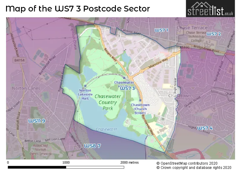
The WS7 3 postcode sector is within the county of Staffordshire.
Did you know? According to the 2021 Census, the WS7 3 postcode sector is home to a bustling 2,735 residents!
Given that each sector allows for 400 unique postcode combinations. Letters C, I, K, M, O and V are not allowed in the last two letters of a postcode. With 77 postcodes already in use, this leaves 323 units available.
The largest settlement in the WS7 3 postal code is BURNTWOOD followed by Chasetown, and Burntwood Business Park.
The WS7 3 Postcode shares a border with WS7 1 (BURNTWOOD, Chase Terrace), WS7 2 (BURNTWOOD, Chase Terrace), WS7 4 (BURNTWOOD, Chasetown), WS8 7 (WALSALL, Brownhills, Clayhanger), WS11 9 (Norton Canes, CANNOCK) and WS12 0 (CANNOCK, Hednesford, Hazel Slade).
The sector is within the post town of BURNTWOOD.
WS7 3 is a postcode sector within the WS7 postcode district which is within the WS Walsall postcode area.
The Royal Mail delivery office for the WS7 3 postal sector is the Lichfield Delivery Office.
The area of the WS7 3 postcode sector is 1.25 square miles which is 3.24 square kilometres or 800.58 square acres.

Map of the WS7 3 Postcode Sector
Explore the WS7 3 postcode sector by using our free interactive map.
| W | S | 7 | - | 3 | X | X |
| W | S | 7 | Space | 3 | Letter | Letter |
Official List of Streets
BURNTWOOD (42 Streets)
Burntwood Business Park (9 Streets)
Chasetown (10 Streets)
Unofficial Streets or Alternative Spellings
BURNTWOOD
ANGLESEY CLOSE BRIDGE CROSS ROAD BURNTWOOD WAY COTTAGE LANE EDWARDS ROAD HILTON ROAD QUEEN STREET THORPE STREETChasetown
HIGHFIELDS ROADNorton Canes
BURNTWOOD ROADChase Terrace
CANNOCK ROADBrownhills
POOL LANEWeather Forecast for WS7 3
Press Button to Show Forecast for Brownhills
| Time Period | Icon | Description | Temperature | Rain Probability | Wind |
|---|---|---|---|---|---|
| 21:00 to 00:00 | Cloudy | 6.0°C (feels like 3.0°C) | 8.00% | ENE 9 mph |
Press Button to Show Forecast for Brownhills
| Time Period | Icon | Description | Temperature | Rain Probability | Wind |
|---|---|---|---|---|---|
| 00:00 to 03:00 | Cloudy | 5.0°C (feels like 2.0°C) | 11.00% | ENE 9 mph | |
| 03:00 to 06:00 | Cloudy | 4.0°C (feels like 1.0°C) | 11.00% | ENE 9 mph | |
| 06:00 to 09:00 | Cloudy | 4.0°C (feels like 1.0°C) | 10.00% | ENE 9 mph | |
| 09:00 to 12:00 | Cloudy | 7.0°C (feels like 4.0°C) | 21.00% | ENE 11 mph | |
| 12:00 to 15:00 | Light rain | 8.0°C (feels like 5.0°C) | 48.00% | ENE 11 mph | |
| 15:00 to 18:00 | Overcast | 8.0°C (feels like 5.0°C) | 19.00% | ENE 11 mph | |
| 18:00 to 21:00 | Overcast | 8.0°C (feels like 5.0°C) | 17.00% | ENE 11 mph | |
| 21:00 to 00:00 | Cloudy | 6.0°C (feels like 3.0°C) | 9.00% | NE 11 mph |
Press Button to Show Forecast for Brownhills
| Time Period | Icon | Description | Temperature | Rain Probability | Wind |
|---|---|---|---|---|---|
| 00:00 to 03:00 | Cloudy | 5.0°C (feels like 2.0°C) | 19.00% | NE 11 mph | |
| 03:00 to 06:00 | Light rain | 5.0°C (feels like 1.0°C) | 54.00% | NNE 11 mph | |
| 06:00 to 09:00 | Light rain | 5.0°C (feels like 1.0°C) | 57.00% | N 11 mph | |
| 09:00 to 12:00 | Heavy rain | 6.0°C (feels like 2.0°C) | 76.00% | NNW 11 mph | |
| 12:00 to 15:00 | Light rain | 8.0°C (feels like 5.0°C) | 50.00% | NW 11 mph | |
| 15:00 to 18:00 | Overcast | 10.0°C (feels like 7.0°C) | 15.00% | WNW 11 mph | |
| 18:00 to 21:00 | Cloudy | 10.0°C (feels like 8.0°C) | 7.00% | W 9 mph | |
| 21:00 to 00:00 | Clear night | 7.0°C (feels like 5.0°C) | 1.00% | WSW 7 mph |
Press Button to Show Forecast for Brownhills
| Time Period | Icon | Description | Temperature | Rain Probability | Wind |
|---|---|---|---|---|---|
| 00:00 to 03:00 | Clear night | 6.0°C (feels like 3.0°C) | 1.00% | SW 7 mph | |
| 03:00 to 06:00 | Clear night | 5.0°C (feels like 2.0°C) | 1.00% | SSW 9 mph | |
| 06:00 to 09:00 | Sunny day | 5.0°C (feels like 2.0°C) | 1.00% | S 9 mph | |
| 09:00 to 12:00 | Partly cloudy (day) | 10.0°C (feels like 7.0°C) | 1.00% | S 11 mph | |
| 12:00 to 15:00 | Overcast | 12.0°C (feels like 10.0°C) | 9.00% | S 13 mph | |
| 15:00 to 18:00 | Cloudy | 13.0°C (feels like 10.0°C) | 7.00% | S 13 mph | |
| 18:00 to 21:00 | Cloudy | 12.0°C (feels like 10.0°C) | 5.00% | S 13 mph | |
| 21:00 to 00:00 | Clear night | 10.0°C (feels like 7.0°C) | 2.00% | SSE 11 mph |
Press Button to Show Forecast for Brownhills
| Time Period | Icon | Description | Temperature | Rain Probability | Wind |
|---|---|---|---|---|---|
| 00:00 to 03:00 | Clear night | 8.0°C (feels like 5.0°C) | 3.00% | SE 11 mph | |
| 03:00 to 06:00 | Clear night | 7.0°C (feels like 4.0°C) | 2.00% | SE 11 mph | |
| 06:00 to 09:00 | Sunny day | 7.0°C (feels like 4.0°C) | 2.00% | ESE 11 mph | |
| 09:00 to 12:00 | Sunny day | 12.0°C (feels like 9.0°C) | 5.00% | ESE 11 mph | |
| 12:00 to 15:00 | Partly cloudy (day) | 14.0°C (feels like 12.0°C) | 10.00% | SE 13 mph | |
| 15:00 to 18:00 | Cloudy | 15.0°C (feels like 13.0°C) | 12.00% | SE 11 mph | |
| 18:00 to 21:00 | Partly cloudy (day) | 14.0°C (feels like 12.0°C) | 11.00% | ESE 11 mph | |
| 21:00 to 00:00 | Cloudy | 12.0°C (feels like 10.0°C) | 8.00% | ESE 9 mph |
Schools and Places of Education Within the WS7 3 Postcode Sector
Chasetown Community School
Community special school
Church Street, Burntwood, Staffordshire, WS7 3QL
Head: Dr Linda James
Ofsted Rating: Good
Inspection: 2023-06-14 (317 days ago)
Website: Visit Chasetown Community School Website
Phone: 01543686315
Number of Pupils: 81
Erasmus Darwin Academy
Academy converter
Pool Road, Burntwood, Staffordshire, WS7 3QW
Head: Mr Phil Walklate
Ofsted Rating: Good
Inspection: 2023-05-17 (345 days ago)
Website: Visit Erasmus Darwin Academy Website
Phone: 01543685828
Number of Pupils: 1141
St Joseph and St Theresa Catholic Primary
Voluntary aided school
High Street, Burntwood, Staffordshire, WS7 3XL
Head: Ms Isabel Walker
Ofsted Rating: Good
Inspection: 2022-12-01 (512 days ago)
Website: Visit St Joseph and St Theresa Catholic Primary Website
Phone: 01543227220
Number of Pupils: 209
House Prices in the WS7 3 Postcode Sector
| Type of Property | 2018 Average | 2018 Sales | 2017 Average | 2017 Sales | 2016 Average | 2016 Sales | 2015 Average | 2015 Sales |
|---|---|---|---|---|---|---|---|---|
| Detached | £269,956 | 39 | £253,299 | 49 | £249,928 | 39 | £200,167 | 12 |
| Semi-Detached | £178,142 | 60 | £180,987 | 69 | £184,595 | 27 | £148,950 | 11 |
| Terraced | £174,500 | 26 | £156,283 | 22 | £151,962 | 23 | £110,083 | 12 |
| Flats | £129,497 | 22 | £122,398 | 5 | £122,967 | 17 | £107,000 | 1 |
Important Postcodes WS7 3 in the Postcode Sector
WS7 3JH is the postcode for Operational Service Depot, Reliant Way, and Lichfield District Council, Reliant Way
WS7 3QL is the postcode for CHASETOWN COMMUNITY SCHOOL, CHURCH STREET, CHASETOWN, and Chasetown Community School, Church Street
WS7 3QW is the postcode for Chasewater Outdoor Education Centre, Pool Road, MAIN SCHOOL BUILDING, Erasmus Darwin Academy, Pool Road, SPORTS HALL, Erasmus Darwin Academy, Pool Road, Erasmus Darwin Academy, Pool Road, ERASUMAS DARWIN ACADEMY, Chasetown Specialist Sports College, Pool Road, and Chasetown Specialist Sports College, Pool Road
WS7 3XG is the postcode for Police Station, High Street
WS7 3XH is the postcode for BURNTWOOD HEALTH & WELLBEING CENTRE, Burntwood Leisure Centre, High Street, BURNTWOOD LEISURE CENTRE, HIGH STREET, CHASETOWN, and Burntwood Leisure Centre, High Street
WS7 3XL is the postcode for St. Joseph & St. Theresa RC Primary School, High Street, Chasetown, St. Joseph & St. Theresa RC Primary School, High Street, and St Joseph And St Theresa Roman Catholic Primary School, High Street, Chasetown
| The WS7 3 Sector is within these Local Authorities |
|
|---|---|
| The WS7 3 Sector is within these Counties |
|
| The WS7 3 Sector is within these Water Company Areas |
|