The B18 7 postcode sector is within the county of West Midlands.
Did you know? According to the 2021 Census, the B18 7 postcode sector is home to a bustling 3,183 residents!
Given that each sector allows for 400 unique postcode combinations. Letters C, I, K, M, O and V are not allowed in the last two letters of a postcode. With 86 postcodes already in use, this leaves 314 units available.
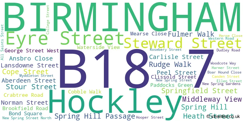
The largest settlements in the B18 7 postal code are BIRMINGHAM and Hockley.
The B18 7 Postcode shares a border with B18 5 (Hockley, BIRMINGHAM), B1 2 (BIRMINGHAM), B1 3 (BIRMINGHAM), B16 0 (BIRMINGHAM, Edgbaston), B16 8 (BIRMINGHAM, Edgbaston, Ladywood), B18 4 (BIRMINGHAM, Hockley, Winson Green) and B18 6 (BIRMINGHAM, Hockley).
The sector is within the post town of BIRMINGHAM.
B18 7 is a postcode sector within the B1 postcode district which is within the B Birmingham postcode area.
The Royal Mail delivery office for the B18 7 postal sector is the unknown.
The area of the B18 7 postcode sector is 0.38 square miles which is 0.98 square kilometres or 241.22 square acres.
Waterways within the B18 7 postcode sector include the Birmingham Canal Navigations, Birmingham Canal Navigations - Soho Loop.

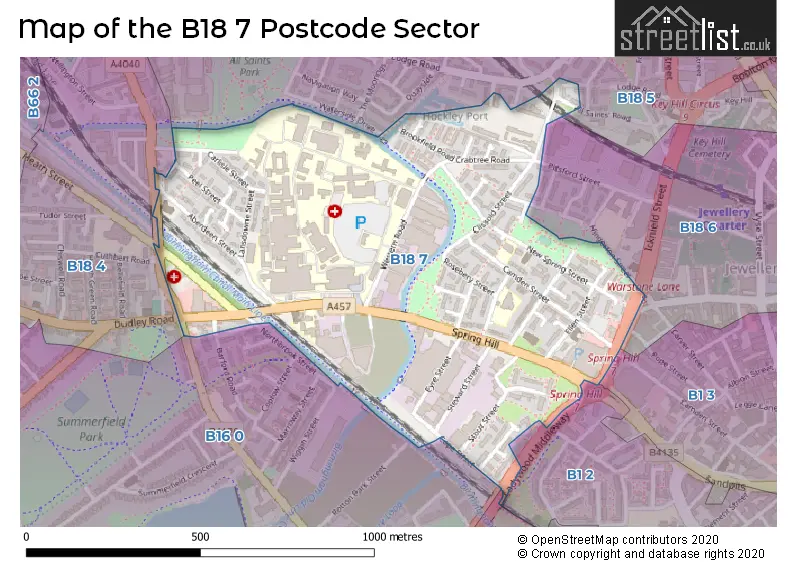
Map of the B18 7 Postcode Sector
Explore the B18 7 postcode sector by using our free interactive map.
| B | 1 | 8 | - | 7 | X | X |
| B | 1 | 8 | Space | 7 | Letter | Letter |
Official List of Streets
BIRMINGHAM (41 Streets)
Unofficial Streets or Alternative Spellings
Hockley
ICKNIELD STREET WATERSIDE DRIVEBIRMINGHAM
BARFORD ROAD CAPSTONE AVENUE CARVER STREET HINGESTON STREET HURDLOW AVENUE ICKNIELD PORT ROAD LADYWOOD MIDDLEWAY NORTHBROOK STREET PITSFORD STREET POPE STREET WARSTONE LANE WINSON GREEN ROAD ALL SAINTS ROAD ARTHUR PLACE BREDON TERRACE CLISSOLD PASSAGE HEATH STREET SOUTH HIGHFIELD TERRACE LOUISA PLACE MEARS CLOSE ROTTON PARK JUNCTION WALKOVER BRIDGE NUMBER 3 RUTLAND TERRACEBIRMINGHAM,
HEATH STREETSchools and Places of Education Within the B18 7 Postcode Sector
Future First Independent School
Other independent school
Hockley Port. All Saints Street, Birmingham, West Midlands, B18 7RL
Head: Mr Aftaab Hussain
Ofsted Rating: Inadequate
Inspection: 2022-03-10 (817 days ago)
Website: Visit Future First Independent School Website
Phone: 01215514837
Number of Pupils: 6
Orion School
Other independent school
14246, Birmingham, , B18 7QD
Head: Mrs Murett Mendez
Ofsted Rating: Good
Inspection: 2023-07-06 (334 days ago)
Website: Visit Orion School Website
Phone: 01212457200
Number of Pupils: 11
St Patrick and St Edmund's Catholic Primary School
Voluntary aided school
Dudley Road, Birmingham, West Midlands, B18 7QW
Head: Miss Kathryn Cairns
Ofsted Rating: Good
Inspection: 2018-12-11 (2002 days ago)
Website: Visit St Patrick and St Edmund's Catholic Primary School Website
Phone: 01212473947
Number of Pupils: 178
House Prices in the B18 7 Postcode Sector
| Type of Property | 2018 Average | 2018 Sales | 2017 Average | 2017 Sales | 2016 Average | 2016 Sales | 2015 Average | 2015 Sales |
|---|---|---|---|---|---|---|---|---|
| Detached | £0 | 0 | £0 | 0 | £0 | 0 | £45,500 | 1 |
| Semi-Detached | £210,000 | 1 | £126,250 | 2 | £100,000 | 2 | £0 | 0 |
| Terraced | £157,596 | 12 | £133,460 | 13 | £118,625 | 20 | £112,941 | 17 |
| Flats | £0 | 0 | £63,075 | 4 | £62,629 | 4 | £58,500 | 2 |
Important Postcodes B18 7 in the Postcode Sector
B18 7AG is the postcode for Summerfield Primary Care Centre, Winson Green Road
B18 7AJ is the postcode for BOA Stage and Screen Production Academy, Stour Street, North West Skills Academy, 48-68 Stour Street, and Ladywood Skills Campus, 48-68 Stour Street
B18 7AL is the postcode for Summerfield Primary Health Care Centre, 134 Heath Street
B18 7BA is the postcode for Broadway Health Centre, Cope Street
B18 7BH is the postcode for Birmingham City Council, Spring Hill Library, Spring Hill
B18 7EE is the postcode for LANSDOWNE HEALTH CENTRE, 34, Lansdowne Street, and Lansdowne Health Centre, 34 Lansdowne Street
B18 7PA is the postcode for St. Edmunds Catholic Primary School, Rosebery Street, and St. Edmunds RC Primary School, Rosebery Street
B18 7QH is the postcode for SUMMERFIELD HOUSE, Sandwell & West Birmingham Hospitals NHS Trust, City Hospital, Dudley Road, MAIN BUILDING, Sandwell & West Birmingham Hospitals NHS Trust, City Hospital, Dudley Road, Sandwell & West Birmingham Hospitals NHS Trust, City Hospital, Dudley Road, MILLERS RESTAURANT, Sandwell & West Birmingham Hospitals NHS Trust, City Hospital, Dudley Road, POST GRADUATE EDUCATION CENTRE, Sandwell & West Birmingham Hospitals NHS Trust, City Hospital, Dudley Road, MAIN BUILDING, Sandwell & West Birmingham Hospitals NHS Trust, City Hospital, MATERNITY BUILDING, Sandwell & West Birmingham Hospitals NHS Trust, City Hospital, SHELDON WITH BIRMINGHAM AND MIDLAND EYE CENTRE, Sandwell & West Birmingham Hospitals NHS Trust, City Hospital, BIRMINGHAM TREATMENT CENTRE, Sandwell & West Birmingham Hospitals NHS Trust, City Hospital, SHELDON WITH BIRMINGHAM AND MIDLAND EYE CENTRE, Sandwell & West Birmingham Hospitals NHS Trust, City Hospital, Dudley Road, MATERNITY BUILDING, Sandwell & West Birmingham Hospitals NHS Trust, City Hospital, Dudley Road, BROOKFIELD HOUSE, Sandwell & West Birmingham Hospitals NHS Trust, City Hospital, Dudley Road, POST GRADUATE EDUCATION CENTRE, Sandwell & West Birmingham Hospitals NHS Trust, City Hospital, BIRMINGHAM TREATMENT CENTRE, Sandwell & West Birmingham Hospitals NHS Trust, City Hospital, Dudley Road, ARDEN HOUSE, Sandwell & West Birmingham Hospitals NHS Trust, City Hospital, Dudley Road, and HEARING CENTRE, Sandwell & West Birmingham Hospitals NHS Trust, City Hospital, Dudley Road
B18 7QW is the postcode for St. Patricks Catholic Primary School, 106 Dudley Road, and St. Patricks RC School, 106 Dudley Road
| The B18 7 Sector is within these Local Authorities |
|
|---|---|
| The B18 7 Sector is within these Counties |
|
| The B18 7 Sector is within these Water Company Areas |
|