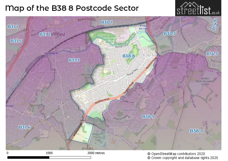
The B38 8 postcode sector stands on the West Midlands and Worcestershire border.
Did you know? According to the 2021 Census, the B38 8 postcode sector is home to a bustling 9,126 residents!
Given that each sector allows for 400 unique postcode combinations. Letters C, I, K, M, O and V are not allowed in the last two letters of a postcode. With 214 postcodes already in use, this leaves 186 units available.
The largest settlements in the B38 8 postal code are BIRMINGHAM and Kings Norton.
The B38 8 Postcode shares a border with B31 2 (BIRMINGHAM, Northfield), B30 1 (BIRMINGHAM, Kings Norton, Bournville), B30 3 (BIRMINGHAM, Kings Norton, Stirchley), B31 3 (BIRMINGHAM, Northfield), B31 4 (BIRMINGHAM, Northfield) and B38 9 (BIRMINGHAM, Kings Norton).
The sector is within the post town of BIRMINGHAM.
B38 8 is a postcode sector within the B38 postcode district which is within the B Birmingham postcode area.
The Royal Mail delivery office for the B38 8 postal sector is the Kings Norton Delivery Office.
The area of the B38 8 postcode sector is 1.10 square miles which is 2.84 square kilometres or 701.23 square acres.
Waterways within the B38 8 postcode sector include the River Rea.

Map of the B38 8 Postcode Sector
Explore the B38 8 postcode sector by using our free interactive map.
| B | 3 | 8 | - | 8 | X | X |
| B | 3 | 8 | Space | 8 | Letter | Letter |
Official List of Streets
BIRMINGHAM (87 Streets)
Kings Norton (10 Streets)
Unofficial Streets or Alternative Spellings
Kings Norton
MASSHOUSE LANE REDHILL ROAD WHARF ROADBIRMINGHAM
ACADEMY ROAD ALVECHURCH ROAD BRANCH ROAD BUCKRIDGE CLOSE EXE CROFT FOYLE ROAD GREEN LANE LEGGING ROAD LIME KILN CLOSE LONGBRIDGE LANE LONGDALES ROAD OAKRIDGE ROAD OLD MEADOW ROAD PASTURES WALK PERSHORE ROAD SOUTH PORTAGE ROAD THE CREST TOMLAN ROAD TUNNEL ROAD WYCHALL ROADNorthfield
HALLOW CLOSE OMBERSLEY WAY BACK ROAD BIRDCAGE WALK CLOVER COURT JAMES COURT MIRY LANE PRIMROSE PARK ROAD REA VALLEY ROUTE REGENCY DRIVEWeather Forecast for B38 8
Press Button to Show Forecast for West Heath
| Time Period | Icon | Description | Temperature | Rain Probability | Wind |
|---|---|---|---|---|---|
| 06:00 to 09:00 | Sunny day | 7.0°C (feels like 4.0°C) | 1.00% | SE 11 mph | |
| 09:00 to 12:00 | Sunny day | 12.0°C (feels like 9.0°C) | 1.00% | SSE 13 mph | |
| 12:00 to 15:00 | Partly cloudy (day) | 15.0°C (feels like 12.0°C) | 5.00% | SSE 16 mph | |
| 15:00 to 18:00 | Cloudy | 15.0°C (feels like 12.0°C) | 8.00% | SSE 16 mph | |
| 18:00 to 21:00 | Cloudy | 13.0°C (feels like 11.0°C) | 10.00% | S 11 mph | |
| 21:00 to 00:00 | Cloudy | 10.0°C (feels like 9.0°C) | 12.00% | SSE 7 mph |
Press Button to Show Forecast for West Heath
| Time Period | Icon | Description | Temperature | Rain Probability | Wind |
|---|---|---|---|---|---|
| 00:00 to 03:00 | Cloudy | 9.0°C (feels like 8.0°C) | 12.00% | SSE 7 mph | |
| 03:00 to 06:00 | Cloudy | 8.0°C (feels like 7.0°C) | 8.00% | SSE 4 mph | |
| 06:00 to 09:00 | Cloudy | 8.0°C (feels like 7.0°C) | 10.00% | SE 4 mph | |
| 09:00 to 12:00 | Cloudy | 11.0°C (feels like 10.0°C) | 9.00% | ESE 4 mph | |
| 12:00 to 15:00 | Cloudy | 13.0°C (feels like 12.0°C) | 14.00% | ENE 4 mph | |
| 15:00 to 18:00 | Cloudy | 14.0°C (feels like 13.0°C) | 17.00% | NE 4 mph | |
| 18:00 to 21:00 | Cloudy | 14.0°C (feels like 12.0°C) | 14.00% | NNE 9 mph | |
| 21:00 to 00:00 | Cloudy | 12.0°C (feels like 10.0°C) | 12.00% | NE 9 mph |
Press Button to Show Forecast for West Heath
| Time Period | Icon | Description | Temperature | Rain Probability | Wind |
|---|---|---|---|---|---|
| 00:00 to 03:00 | Cloudy | 10.0°C (feels like 8.0°C) | 14.00% | N 9 mph | |
| 03:00 to 06:00 | Cloudy | 10.0°C (feels like 7.0°C) | 15.00% | N 11 mph | |
| 06:00 to 09:00 | Overcast | 9.0°C (feels like 7.0°C) | 14.00% | NNW 11 mph | |
| 09:00 to 12:00 | Cloudy | 12.0°C (feels like 10.0°C) | 11.00% | N 11 mph | |
| 12:00 to 15:00 | Cloudy | 15.0°C (feels like 13.0°C) | 7.00% | N 11 mph | |
| 15:00 to 18:00 | Partly cloudy (day) | 17.0°C (feels like 14.0°C) | 3.00% | N 11 mph | |
| 18:00 to 21:00 | Sunny day | 16.0°C (feels like 13.0°C) | 5.00% | N 11 mph | |
| 21:00 to 00:00 | Clear night | 12.0°C (feels like 10.0°C) | 4.00% | N 11 mph |
Schools and Places of Education Within the B38 8 Postcode Sector
Fairway Primary Academy
Academy converter
Muirfield Gardens, Birmingham, West Midlands, B38 8XQ
Head: Headteacher Darren Mann
Ofsted Rating: Good
Inspection: 2019-02-05 (1911 days ago)
Website: Visit Fairway Primary Academy Website
Phone: 01214643200
Number of Pupils: 197
Kings Norton Nursery School
Local authority nursery school
Westhill Road, Birmingham, West Midlands, B38 8SY
Head: Mrs Nicola Pinnegar
Ofsted Rating: Outstanding
Inspection: 2023-10-04 (209 days ago)
Website: Visit Kings Norton Nursery School Website
Phone: 01216753993
Number of Pupils: 89
St Thomas Aquinas Catholic School
Academy converter
Wychall Lane, Birmingham, West Midlands, B38 8AP
Head: Principal Chris Martin
Ofsted Rating: Good
Inspection: 2018-11-08 (2000 days ago)
Website: Visit St Thomas Aquinas Catholic School Website
Phone: 01214644643
Number of Pupils: 1168
West Heath Primary School
Community school
Rednal Road, Birmingham, West Midlands, B38 8HU
Head: Mrs Michelle Hooper
Ofsted Rating: Good
Inspection: 2019-09-26 (1678 days ago)
Website: Visit West Heath Primary School Website
Phone: 01214584257
Number of Pupils: 404
House Prices in the B38 8 Postcode Sector
| Type of Property | 2018 Average | 2018 Sales | 2017 Average | 2017 Sales | 2016 Average | 2016 Sales | 2015 Average | 2015 Sales |
|---|---|---|---|---|---|---|---|---|
| Detached | £341,176 | 17 | £338,232 | 31 | £375,639 | 23 | £341,180 | 25 |
| Semi-Detached | £205,508 | 61 | £211,749 | 53 | £193,385 | 63 | £178,155 | 41 |
| Terraced | £174,134 | 71 | £156,215 | 48 | £150,890 | 61 | £140,262 | 56 |
| Flats | £116,647 | 17 | £99,988 | 21 | £108,091 | 22 | £89,634 | 19 |
Important Postcodes B38 8 in the Postcode Sector
B38 8AP is the postcode for St. Thomas Aquinas Catholic School, Wychall Lane, and ST THOMAS AQUINAS R C GRAMMAR SCHOOL, WYCHALL LANE, BIRMINGHAM
B38 8AX is the postcode for West Heath Primary Care Centre, 481 Rednal Road
B38 8HR is the postcode for BLOCK 2, Birmingham Community Healthcare Trust, West Heath Hospital, BLOCK 16 WARDS 10, 11, 12 & 14, South Birmingham PCT, West Heath Hospital, Birmingham Community Healthcare Trust, West Heath Hospital, BLOCK 23, Birmingham Community Healthcare Trust, West Heath Hospital, West Heath Hospital, Rednal Road, BLOCK 40, Birmingham Community Healthcare Trust, West Heath Hospital, BLOCK 16 WARDS 10, 11, 12 & 14, Birmingham Community Healthcare Trust, West Heath Hospital, BLOCK 32, Birmingham Community Healthcare Trust, West Heath Hospital, and BLOCK 18/19, Birmingham Community Healthcare Trust, West Heath Hospital
B38 8HS is the postcode for CHARLES HOUSE, 501 REDNAL ROAD
B38 8HU is the postcode for West Heath Primary School, Rednal Road
B38 8QS is the postcode for The Kings Norton Surgery, 66 Redditch Road
B38 8QT is the postcode for Cadbury College, Cadbury Sixth Form College, Downland Close, and Cadbury Sixth Form College, Downland Close
B38 8SY is the postcode for Kings Norton Nursery School, Westhill Road
B38 8TE is the postcode for Wychall Lane Surgery, 9-11 Wychall Lane
B38 8XJ is the postcode for The Fairway Day Centre, 2 The Fairway, and The Fairway Day Centre, 2 The Fairway, Kings Norton
B38 8XQ is the postcode for Fairway Primary School, Muirfield Gardens, and Fairway Primary Academy, Muirfield Gardens
| The B38 8 Sector is within these Local Authorities |
|
|---|---|
| The B38 8 Sector is within these Counties |
|
| The B38 8 Sector is within these Water Company Areas |
|