The B46 2 postcode sector is within the county of Warwickshire.
Did you know? According to the 2021 Census, the B46 2 postcode sector is home to a bustling 2,411 residents!
Given that each sector allows for 400 unique postcode combinations. Letters C, I, K, M, O and V are not allowed in the last two letters of a postcode. With 166 postcodes already in use, this leaves 234 units available.
The largest settlements in the B46 2 postal code are Coleshill and Furnace End.
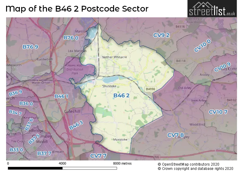
The B46 2 Postcode shares a border with B46 1 (Coleshill, Water Orton), B46 3 (Coleshill), B76 0 (Lea Marston, Marston, Curdworth), CV9 2 (Grendon, ATHERSTONE, Hurley), CV10 0 (NUNEATON, Hartshill, Ridge Lane), B78 2 (Kingsbury, Middleton, Piccadilly), CV7 7 (Balsall Common, Meriden, Berkswell) and CV7 8 (Keresley End, Fillongley, Arley).
The sector is within the post town of BIRMINGHAM.
B46 2 is a postcode sector within the B46 postcode district which is within the B Birmingham postcode area.
The Royal Mail delivery office for the B46 2 postal sector is the Coleshill Delivery Office.
The area of the B46 2 postcode sector is 15.40 square miles which is 39.88 square kilometres or 9,854.50 square acres.
The B46 2 postcode sector is crossed by the M6 motorway.
Waterways within the B46 2 postcode sector include the River Tame, River Cole.

Map of the B46 2 Postcode Sector
Explore the B46 2 postcode sector by using our free interactive map.
| B | 4 | 6 | - | 2 | X | X |
| B | 4 | 6 | Space | 2 | Letter | Letter |
Official List of Streets
Coleshill (57 Streets)
Furnace End (4 Streets)
Unofficial Streets or Alternative Spellings
Coleshill
GORSEY LANE MAXSTOKE LANE SHAWBURY VILLAGEKingsbury
COVENTRY ROADArley
TAMWORTH ROADFillongley
GREEN END ROADSchools and Places of Education Within the B46 2 Postcode Sector
Shustoke CofE Primary School
Voluntary controlled school
Forge Road, Birmingham, West Midlands, B46 2AU
Head: Miss Michele Wall
Ofsted Rating: Good
Inspection: 2021-12-09 (906 days ago)
Website: Visit Shustoke CofE Primary School Website
Phone: 01675481319
Number of Pupils: 200
THE SECRET GARDEN SCHOOL
Other independent school
SHUSTOKE HALL, , , B46 2RJ
Head: Mrs ANNETTTE GADD
Ofsted Rating: Good
Inspection: 2022-03-17 (808 days ago)
Website: Visit THE SECRET GARDEN SCHOOL Website
Phone: 01675488825
Number of Pupils: 26
House Prices in the B46 2 Postcode Sector
| Type of Property | 2018 Average | 2018 Sales | 2017 Average | 2017 Sales | 2016 Average | 2016 Sales | 2015 Average | 2015 Sales |
|---|---|---|---|---|---|---|---|---|
| Detached | £574,563 | 16 | £445,748 | 20 | £405,357 | 14 | £322,237 | 16 |
| Semi-Detached | £322,438 | 8 | £331,318 | 11 | £298,900 | 10 | £280,634 | 16 |
| Terraced | £229,042 | 12 | £171,667 | 6 | £188,643 | 7 | £185,000 | 8 |
| Flats | £0 | 0 | £0 | 0 | £0 | 0 | £0 | 0 |
Important Postcodes B46 2 in the Postcode Sector
B46 2AU is the postcode for Shustoke C of E Primary School, Forge Road
| The B46 2 Sector is within these Local Authorities |
|
|---|---|
| The B46 2 Sector is within these Counties |
|
| The B46 2 Sector is within these Water Company Areas |
|