The B93 postcode district is a postal district located in the B Birmingham postcode area with a population of 20,066 residents according to the 2021 England and Wales Census.
The area of the B93 postcode district is 11.25 square miles which is 29.14 square kilometres or 7,199.71 acres.
Currently, the B93 district has about 531 postcode units spread across 3 geographic postcode sectors.
Given that each sector allows for 400 unique postcode combinations, the district has a capacity of 1,200 postcodes. With 531 postcodes already in use, this leaves 669 units available.
The largest settlement in the B93 postal code is Knowle followed by Dorridge, and Bentley Heath.
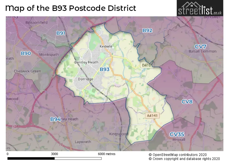
The B93 Postcode shares a border with B91 (SOLIHULL, Catherine-de-Barnes), B92 (SOLIHULL, Hampton-in-Arden, Barston), CV7 (Balsall Common, Exhall, Meriden), B94 (Hockley Heath, Lapworth, Earlswood), B90 (Shirley, Cheswick Green, Tidbury Green) and CV8 (KENILWORTH, Wolston, Ryton On Dunsmore).
Based on the data provided for the B93 postcode district, the primary settlement is Chadwick End in Solihull, Warwickshire. Other significant settlements in the B93 district include Knowle and Bentley Heath, both also in Solihull, West Midlands. The county associated with the B93 postcode district is Warwickshire. The most significant post town in the B93 district is Solihull.
For the district B93, we have data on 4 postcode sectors. Here's a breakdown: The sector B93 0, covers Knowle and Chadwick End in West Midlands. The sector B93 3 is non-geographic. It's often designated for PO Boxes, large organisations, or special services. The sector B93 8, covers Dorridge and Bentley Heath in West Midlands. The sector B93 9, covers Knowle in West Midlands.

Map of the B93 Postcode District
Explore the B93 postcode district by using our free interactive map.
When it comes to local government, postal geography often disregards political borders. However, for a breakdown in the B93 District: the district mostly encompasses the Solihull District (B) (500 postcodes), and finally, the Warwick District area (17 postcodes).
Weather Forecast for B93
Press Button to Show Forecast for Knowle (West Midlands)
| Time Period | Icon | Description | Temperature | Rain Probability | Wind |
|---|---|---|---|---|---|
| 06:00 to 09:00 | Cloudy | 4.0°C (feels like 2.0°C) | 5.00% | ENE 4 mph | |
| 09:00 to 12:00 | Cloudy | 6.0°C (feels like 4.0°C) | 6.00% | ENE 7 mph | |
| 12:00 to 15:00 | Overcast | 9.0°C (feels like 7.0°C) | 11.00% | ENE 7 mph | |
| 15:00 to 18:00 | Overcast | 10.0°C (feels like 8.0°C) | 12.00% | ENE 7 mph | |
| 18:00 to 21:00 | Cloudy | 9.0°C (feels like 7.0°C) | 10.00% | E 7 mph | |
| 21:00 to 00:00 | Cloudy | 7.0°C (feels like 4.0°C) | 12.00% | ENE 7 mph |
Press Button to Show Forecast for Knowle (West Midlands)
| Time Period | Icon | Description | Temperature | Rain Probability | Wind |
|---|---|---|---|---|---|
| 00:00 to 03:00 | Cloudy | 5.0°C (feels like 3.0°C) | 12.00% | ENE 7 mph | |
| 03:00 to 06:00 | Cloudy | 4.0°C (feels like 2.0°C) | 13.00% | ENE 7 mph | |
| 06:00 to 09:00 | Cloudy | 5.0°C (feels like 2.0°C) | 14.00% | ENE 7 mph | |
| 09:00 to 12:00 | Cloudy | 7.0°C (feels like 4.0°C) | 19.00% | ENE 9 mph | |
| 12:00 to 15:00 | Light rain | 9.0°C (feels like 6.0°C) | 53.00% | ENE 9 mph | |
| 15:00 to 18:00 | Overcast | 10.0°C (feels like 8.0°C) | 23.00% | ENE 9 mph | |
| 18:00 to 21:00 | Cloudy | 10.0°C (feels like 7.0°C) | 19.00% | ENE 9 mph | |
| 21:00 to 00:00 | Overcast | 8.0°C (feels like 5.0°C) | 24.00% | NE 11 mph |
Press Button to Show Forecast for Knowle (West Midlands)
| Time Period | Icon | Description | Temperature | Rain Probability | Wind |
|---|---|---|---|---|---|
| 00:00 to 03:00 | Light rain | 7.0°C (feels like 4.0°C) | 52.00% | NE 9 mph | |
| 03:00 to 06:00 | Heavy rain | 7.0°C (feels like 4.0°C) | 72.00% | NE 9 mph | |
| 06:00 to 09:00 | Heavy rain | 7.0°C (feels like 4.0°C) | 73.00% | NNE 9 mph | |
| 09:00 to 12:00 | Heavy rain | 8.0°C (feels like 6.0°C) | 75.00% | NNE 9 mph | |
| 12:00 to 15:00 | Light rain shower (day) | 10.0°C (feels like 8.0°C) | 42.00% | NNE 9 mph | |
| 15:00 to 18:00 | Heavy rain shower (day) | 11.0°C (feels like 9.0°C) | 58.00% | NW 11 mph | |
| 18:00 to 21:00 | Heavy rain shower (day) | 11.0°C (feels like 9.0°C) | 55.00% | NNW 9 mph | |
| 21:00 to 00:00 | Partly cloudy (night) | 8.0°C (feels like 7.0°C) | 11.00% | WNW 7 mph |
Where is the B93 Postcode District?
The B93 postcode district is located in Solihull. It is associated with nearby towns such as Henley-in-Arden in the South West (5.66 miles away), Kenilworth in the East (6.05 miles away), Birmingham in the North West (9.16 miles away), Warwick in the South East (9.42 miles away), and Bedworth in the North East (12.66 miles away). Additionally, the B93 postcode district is approximately 90.94 miles away from the center of London.
The district is within the post town of SOLIHULL.
The sector has postcodes within the nation of England.
The B93 Postcode District is covers the following regions.
- Solihull - West Midlands - West Midlands (England)
- Warwickshire - Herefordshire, Worcestershire and Warwickshire - West Midlands (England)
| Postcode Sector | Delivery Office |
|---|---|
| B93 0 | Knowle Delivery Office |
| B93 8 | Knowle Delivery Office |
| B93 9 | Knowle Delivery Office |
| B | 9 | 3 | - | X | X | X |
| B | 9 | 3 | Space | Numeric | Letter | Letter |
Tourist Attractions within the Postcode Area
We found 1 visitor attractions within the B93 postcode area
| Baddesley Clinton |
|---|
| Historic Properties |
| Historic House / House and Garden / Palace |
| View Baddesley Clinton on Google Maps |
Current Monthly Rental Prices
| # Bedrooms | Min Price | Max Price | Avg Price |
|---|---|---|---|
| 1 | £762 | £775 | £769 |
| 2 | £950 | £1,950 | £1,298 |
| 3 | £1,750 | £2,300 | £2,025 |
| 4 | £2,195 | £3,200 | £2,548 |
| 5 | £3,995 | £3,995 | £3,995 |
| 6 | £3,950 | £3,950 | £3,950 |
Current House Prices
| # Bedrooms | Min Price | Max Price | Avg Price |
|---|---|---|---|
| 3 | £995,950 | £1,200,000 | £1,097,975 |
| 4 | £900,000 | £1,750,000 | £1,119,500 |
| 5 | £895,000 | £2,500,000 | £1,654,375 |
| 6 | £1,000,000 | £2,000,000 | £1,498,333 |
| 7 | £1,650,000 | £1,900,000 | £1,775,000 |
Estate Agents who Operate in the B93 District
| Logo | Name | Brand Name | Address | Contact Number | Total Properties |
|---|---|---|---|---|---|
 | Knowle | Xact Homes | 1632-1634, High Street, Knowle, Solihull, B93 0JU | 01564 334705 | 69 |
 | Dorridge | DM & Co. Homes | 2 Forest Court Shopping Centre, Solihull, B93 8FG | 0121 387 6788 | 19 |
 | Bournemouth | McCarthy & Stone Resales | 100 Holdenhurst Road, Bournemouth, BH8 8AQ | 03455 564122 | 9 |
 | Knowle | EB&P | EB&P Limited 124 Station Road Knowle Solihull B93 0EP | 01564 331105 | 9 |
 | Knowle | Hunters | 1626 High Street Knowle B93 0JU | 01564 335024 | 8 |
| Type of Property | 2018 Average | 2018 Sales | 2017 Average | 2017 Sales | 2016 Average | 2016 Sales | 2015 Average | 2015 Sales |
|---|---|---|---|---|---|---|---|---|
| Detached | £682,187 | 186 | £673,448 | 161 | £604,232 | 163 | £564,157 | 230 |
| Semi-Detached | £406,458 | 88 | £372,998 | 81 | £369,544 | 89 | £400,771 | 91 |
| Terraced | £372,606 | 46 | £383,144 | 72 | £328,117 | 50 | £301,533 | 52 |
| Flats | £287,325 | 38 | £261,046 | 56 | £271,298 | 76 | £241,084 | 126 |