The BS10 postcode district is a postal district located in the BS Bristol postcode area with a population of 30,605 residents according to the 2021 England and Wales Census.
The area of the BS10 postcode district is 7.78 square miles which is 20.14 square kilometres or 4,976.17 acres.
Currently, the BS10 district has about 723 postcode units spread across 3 geographic postcode sectors.
Given that each sector allows for 400 unique postcode combinations, the district has a capacity of 1,200 postcodes. With 723 postcodes already in use, this leaves 477 units available.
The largest settlement in the BS10 postal code is BRISTOL followed by Westbury-on-Trym, and Henbury.
The postcode area has a boundary with The Bristol Channel.
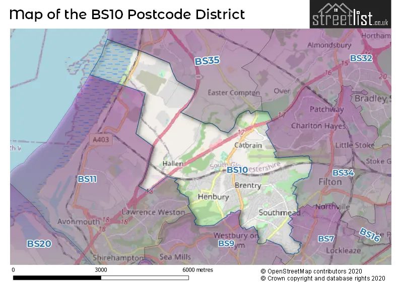
The BS10 Postcode shares a border with BS7 (BRISTOL, Horfield, Bishopston), BS9 (BRISTOL, Westbury-on-Trym, Stoke Bishop), BS34 (Patchway, Stoke Gifford, Filton), BS11 (BRISTOL, Shirehampton, Avonmouth) and BS35 (Thornbury, Alveston, Severn Beach).
The primary settlement in the BS10 postcode district is Bristol, which has the highest count of 158. Other significant settlements in the district include Southmead, Westbury-on-Trym, Brentry, Hallen, and Henbury. Bristol is located in the county of Gloucestershire in England. The most significant post town in the district is also Bristol.
For the district BS10, we have data on 3 postcode sectors. Here's a breakdown: The sector BS10 5, covers Bristol and Westbury-On-Trym in Bristol. The sector BS10 6, covers Bristol in Bristol. The sector BS10 7, covers Bristol and Henbury in Bristol.

Map of the BS10 Postcode District
Explore the BS10 postcode district by using our free interactive map.
When it comes to local government, postal geography often disregards political borders. However, for a breakdown in the BS10 District: the district mostly encompasses the City of Bristol (B) (667 postcodes), and finally, the South Gloucestershire area (72 postcodes).
Where is the BS10 Postcode District?
The postcode district BS10 is located in Bristol. It is located near several towns, including Caldicot to the North West, Chepstow to the North, Clevedon to the South West, Badminton to the East, Wotton-under-Edge to the North East, and Bath to the South East. The distance between BS10 and London is approximately 107.8 miles.
The district is within the post town of BRISTOL.
The sector has postcodes within the nation of England.
The BS10 Postcode District is covers the following regions.
- Bristol, City of - Gloucestershire, Wiltshire and Bath/Bristol area - South West (England)
- Bath and North East Somerset, North Somerset and South Gloucestershire - Gloucestershire, Wiltshire and Bath/Bristol area - South West (England)
Weather Forecast for BS10
Press Button to Show Forecast for Henbury
| Time Period | Icon | Description | Temperature | Rain Probability | Wind |
|---|---|---|---|---|---|
| 03:00 to 06:00 | Overcast | 12.0°C (feels like 11.0°C) | 8.00% | SSW 4 mph | |
| 06:00 to 09:00 | Cloudy | 13.0°C (feels like 11.0°C) | 8.00% | S 9 mph | |
| 09:00 to 12:00 | Cloudy | 15.0°C (feels like 12.0°C) | 6.00% | S 13 mph | |
| 12:00 to 15:00 | Cloudy | 17.0°C (feels like 14.0°C) | 12.00% | SSE 16 mph | |
| 15:00 to 18:00 | Light rain | 16.0°C (feels like 13.0°C) | 54.00% | SSE 16 mph | |
| 18:00 to 21:00 | Light rain | 15.0°C (feels like 12.0°C) | 62.00% | SSE 16 mph | |
| 21:00 to 00:00 | Heavy rain | 14.0°C (feels like 12.0°C) | 88.00% | SE 11 mph |
Press Button to Show Forecast for Henbury
| Time Period | Icon | Description | Temperature | Rain Probability | Wind |
|---|---|---|---|---|---|
| 00:00 to 03:00 | Heavy rain | 14.0°C (feels like 12.0°C) | 85.00% | SE 9 mph | |
| 03:00 to 06:00 | Light rain | 13.0°C (feels like 12.0°C) | 58.00% | SSE 7 mph | |
| 06:00 to 09:00 | Light rain | 13.0°C (feels like 12.0°C) | 58.00% | SE 7 mph | |
| 09:00 to 12:00 | Light rain | 14.0°C (feels like 13.0°C) | 59.00% | SSE 9 mph | |
| 12:00 to 15:00 | Cloudy | 15.0°C (feels like 13.0°C) | 22.00% | SSE 11 mph | |
| 15:00 to 18:00 | Cloudy | 16.0°C (feels like 14.0°C) | 18.00% | SSE 13 mph | |
| 18:00 to 21:00 | Cloudy | 16.0°C (feels like 14.0°C) | 14.00% | SSE 11 mph | |
| 21:00 to 00:00 | Cloudy | 14.0°C (feels like 12.0°C) | 8.00% | SE 9 mph |
Press Button to Show Forecast for Henbury
| Time Period | Icon | Description | Temperature | Rain Probability | Wind |
|---|---|---|---|---|---|
| 00:00 to 03:00 | Clear night | 13.0°C (feels like 11.0°C) | 5.00% | SE 9 mph | |
| 03:00 to 06:00 | Partly cloudy (night) | 12.0°C (feels like 11.0°C) | 4.00% | ESE 9 mph | |
| 06:00 to 09:00 | Sunny day | 12.0°C (feels like 11.0°C) | 3.00% | ESE 11 mph | |
| 09:00 to 12:00 | Cloudy | 15.0°C (feels like 13.0°C) | 14.00% | SE 11 mph | |
| 12:00 to 15:00 | Partly cloudy (day) | 17.0°C (feels like 14.0°C) | 13.00% | SE 13 mph | |
| 15:00 to 18:00 | Partly cloudy (day) | 17.0°C (feels like 15.0°C) | 10.00% | SSE 11 mph | |
| 18:00 to 21:00 | Sunny day | 16.0°C (feels like 15.0°C) | 8.00% | SSE 9 mph | |
| 21:00 to 00:00 | Clear night | 14.0°C (feels like 13.0°C) | 2.00% | SE 7 mph |
Press Button to Show Forecast for Henbury
| Time Period | Icon | Description | Temperature | Rain Probability | Wind |
|---|---|---|---|---|---|
| 00:00 to 03:00 | Clear night | 12.0°C (feels like 11.0°C) | 2.00% | ESE 4 mph | |
| 03:00 to 06:00 | Clear night | 11.0°C (feels like 10.0°C) | 1.00% | E 4 mph | |
| 06:00 to 09:00 | Sunny day | 12.0°C (feels like 11.0°C) | 2.00% | E 4 mph | |
| 09:00 to 12:00 | Sunny day | 15.0°C (feels like 15.0°C) | 5.00% | ESE 4 mph | |
| 12:00 to 15:00 | Partly cloudy (day) | 17.0°C (feels like 16.0°C) | 14.00% | S 7 mph | |
| 15:00 to 18:00 | Light rain shower (day) | 17.0°C (feels like 16.0°C) | 38.00% | SE 7 mph | |
| 18:00 to 21:00 | Cloudy | 16.0°C (feels like 16.0°C) | 15.00% | W 7 mph | |
| 21:00 to 00:00 | Cloudy | 15.0°C (feels like 14.0°C) | 9.00% | WNW 4 mph |
| Postcode Sector | Delivery Office |
|---|---|
| BS10 5 | Westbury On Trym Delivery Office |
| BS10 6 | Westbury On Trym Delivery Office |
| BS10 7 | Westbury On Trym Delivery Office |
| B | S | 1 | 0 | - | X | X | X |
| B | S | 1 | 0 | Space | Numeric | Letter | Letter |
Tourist Attractions within the BS10 Postcode Area
We found 1 visitor attractions within the BS10 postcode area
| Wild Place Project |
|---|
| Wildlife |
| Safari Park / Zoo / Aquarium / Aviary |
| View Wild Place Project on Google Maps |
Current Monthly Rental Prices
| # Bedrooms | Min Price | Max Price | Avg Price |
|---|---|---|---|
| 1 | £700 | £700 | £700 |
| 2 | £1,290 | £1,290 | £1,290 |
| 3 | £1,600 | £1,650 | £1,625 |
| 4 | £2,250 | £2,600 | £2,413 |
| 6 | £1,127 | £4,500 | £3,001 |
Current House Prices
| # Bedrooms | Min Price | Max Price | Avg Price |
|---|---|---|---|
| 2 | £650,000 | £650,000 | £650,000 |
| 3 | £485,000 | £675,000 | £545,825 |
| 4 | £480,000 | £990,000 | £652,079 |
| 5 | £530,000 | £880,000 | £721,000 |
| 6 | £600,000 | £650,000 | £625,000 |
Estate Agents who Operate in the BS10 District
| Logo | Name | Brand Name | Address | Contact Number | Total Properties |
|---|---|---|---|---|---|
 | Westbury on Trym | Ocean | 73 Westbury Hill, Bristol, BS9 3AD | 0117 463 0073 | 18 |
 | Westbury On Trym | CJ Hole | 25 Canford Lane, Westbury-On-Trym, Bristol, BS9 3DQ | 0117 463 1886 | 18 |
 | Westbury-On-Trym | Connells | 6 Canford Lane, Westbury-On-Trym, Bristol, BS9 3DH | 0117 463 7854 | 17 |
 | Westbury-On-Trym | Andrews Estate Agents | 4 High Street Westbury-On-Trym Bristol BS9 3DU | 0117 463 7011 | 10 |
 | Henleaze | CJ Hole | 108 Henleaze Road Henleaze Bristol BS9 4JZ | 0117 463 0437 | 9 |
Yearly House Price Averages for the BS10 Postcode District
| Type of Property | 2018 Average | 2018 Sales | 2017 Average | 2017 Sales | 2016 Average | 2016 Sales | 2015 Average | 2015 Sales |
|---|---|---|---|---|---|---|---|---|
| Detached | £361,197 | 30 | £386,444 | 36 | £382,809 | 34 | £321,558 | 42 |
| Semi-Detached | £274,114 | 147 | £274,866 | 152 | £265,797 | 144 | £238,954 | 144 |
| Terraced | £242,686 | 142 | £236,363 | 121 | £237,168 | 135 | £195,280 | 176 |
| Flats | £191,799 | 82 | £179,274 | 82 | £167,535 | 99 | £143,968 | 84 |