The BS14 0 postcode sector stands on the Bristol and Somerset border.
Did you know? According to the 2021 Census, the BS14 0 postcode sector is home to a bustling 10,728 residents!
Given that each sector allows for 400 unique postcode combinations. Letters C, I, K, M, O and V are not allowed in the last two letters of a postcode. With 279 postcodes already in use, this leaves 121 units available.
The largest settlement in the BS14 0 postal code is BRISTOL followed by Whitchurch, and Hawkfield Business Park.
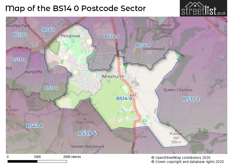
The BS14 0 Postcode shares a border with BS4 1 (BRISTOL, Knowle), BS13 0 (BRISTOL), BS14 8 (BRISTOL, Stockwood), BS31 2 (Keynsham), BS13 7 (BRISTOL, Bishopsworth, Bedminster Down), BS14 9 (BRISTOL, Hengrove), BS39 4 (Pensford, Stanton Drew, Compton Dando) and BS41 8 (Dundry).
The sector is within the post town of BRISTOL.
BS14 0 is a postcode sector within the BS14 postcode district which is within the BS Bristol postcode area.
The Royal Mail delivery office for the BS14 0 postal sector is the Bristol South East Delivery Office.
The area of the BS14 0 postcode sector is 3.40 square miles which is 8.81 square kilometres or 2,177.39 square acres.

Map of the BS14 0 Postcode Sector
Explore the BS14 0 postcode sector by using our free interactive map.
| B | S | 1 | 4 | - | 0 | X | X |
| B | S | 1 | 4 | Space | 0 | Letter | Letter |
Official List of Streets
BRISTOL (133 Streets)
Whitchurch (19 Streets)
Hawkfield Business Park (2 Streets)
Hengrove Park (1 Streets)
Unofficial Streets or Alternative Spellings
Compton Dando
SLATE LANEKeynsham
CHARLTON ROAD STOCKWOOD LANEBRISTOL
AIRPORT ROAD BIFIELD CLOSE BISHPORT AVENUE CHILTERN CLOSE CRESWICKE ROAD DENLEIGH CLOSE DRAGONFLY LANE FILWOOD PARK LANE FORTFIELD ROAD FULFORD ROAD HARTCLIFFE WAY HAWKFIELD ROAD HEATHFIELD CRESCENT LOCKEMOR ROAD RIDGEWAY GARDENS RIDGEWAY LANE ROMAN FARM ROAD STOCKWOOD ROAD TARNOCK AVENUE WILLIAM JESSOP WAY BLACKACRE BRIERY LEAZE ROAD BUTTERFLY LANE CLEWESON RISE CLEWSON RISE GRASSMEERS DRIVE HALFACRE CLOSE HALFACRE LANE HANGAR ROAD HANGER WAY HENGROVE LEISURE PARK HENGROVE WAY ROUNDABOUT HIGHWALL LANE LANDING LIGHTS LIONS COURT FARM LONGACRE ROAD MAESKNOLL LANE STAUNTON MANOR COURTYARD TRACEY CLOSE WHITCHCHURCH LANE WHITCHURCH RAILWAY PATH WITHYBED YARDPensford
BLACKROCK LANE WOOLLARD LANEBishopsworth
WHITCHURCH LANESchools and Places of Education Within the BS14 0 Postcode Sector
Perry Court E-ACT Academy
Academy sponsor led
Great Hayles Road, Hengrove, Bristol, BS14 0AX
Head: Ms Stephanie Moore
Ofsted Rating: Good
Inspection: 2022-01-27 (847 days ago)
Website: Visit Perry Court E-ACT Academy Website
Phone: 01173772078
Number of Pupils: 462
Wansdyke Primary School
Academy converter
School Close, Bristol, , BS14 0DU
Head: Miss Emily Harris
Ofsted Rating: Good
Inspection: 2023-01-19 (490 days ago)
Website: Visit Wansdyke Primary School Website
Phone: 01179030218
Number of Pupils: 209
House Prices in the BS14 0 Postcode Sector
| Type of Property | 2018 Average | 2018 Sales | 2017 Average | 2017 Sales | 2016 Average | 2016 Sales | 2015 Average | 2015 Sales |
|---|---|---|---|---|---|---|---|---|
| Detached | £385,034 | 52 | £375,787 | 13 | £344,085 | 17 | £340,880 | 38 |
| Semi-Detached | £277,978 | 86 | £265,563 | 52 | £253,076 | 50 | £221,209 | 55 |
| Terraced | £234,321 | 77 | £232,741 | 58 | £209,429 | 62 | £183,541 | 69 |
| Flats | £134,499 | 6 | £130,533 | 10 | £118,290 | 11 | £102,500 | 6 |
Important Postcodes BS14 0 in the Postcode Sector
BS14 0AX is the postcode for Perry Court Junior & Infant School, Great Hayles Road, JUNIOR BUILDING, Perry Court Junior & Infant School, Great Hayles Road, Perry Court New Block, Great Hayles Road, and INFANT BUILDING, Perry Court Junior & Infant School, Great Hayles Road
BS14 0BB is the postcode for 25 Osprey Court, Hawkfield Way, Hartcliffe
BS14 0BL is the postcode for E-ACT Septimus Building, Septimus Business Park, Hawkfield Way
BS14 0DB is the postcode for City of Bristol College, South Bristol Skills Academy, The Boulevard, SOUTH BRISTOL SKILLS ACADEMY, City of Bristol College, The Boulevard, and City of Bristol College, SBSA, The Boulevard
BS14 0DU is the postcode for Wansdyke Primary School, School Close, and Wansdyke School, School Close
BS14 0JZ is the postcode for Hengrove Park Leisure Centre, The Boulevard, Community Health Partnerships, South Bristol Comunity Hospital, Whitchurch Lane, South Bristol Comunity Hospital, Whitchurch Lane, South Bristol Comunity Hospital, Whitchurch Lane, Whitchurch, and Hengrove Park Leisure Centre, The Boulevard, Whitchurch Lane
BS14 0LL is the postcode for GROVE BUILDING BRIDGE FARM PRIMARY SCHOOL, Bridge Farm Infant School, East Dundry Road, Orchard Building, Bridge Farm Primary School, East Dundry Road, BUILDING F, Bridge Farm Primary School, East Dundry Road, BUILDING A, Bridge Farm Primary School, East Dundry Road, and BUILDING A, Bridge Farm Primary School
BS14 0PT is the postcode for Whitchurch Primary School, 22 Bristol Road, Whitchurch Primary School, 22 Bristol Road, Whitchurch, and Four Classroom Teaching Block, Whitchurch Primary School, 22 Bristol Road
BS14 0SU is the postcode for Whitchurch Health Centre, Armada Road
BS14 0SX is the postcode for Bristol City Council, Whitchurch Library, 7 Oatlands Avenue
BS14 0TJ is the postcode for BRISTOL CITY COUNCIL - TOP FLOOR, Somerfield Stores, Somerfield House, Whitchurch Lane
| The BS14 0 Sector is within these Local Authorities |
|
|---|---|
| The BS14 0 Sector is within these Counties |
|
| The BS14 0 Sector is within these Water Company Areas |
|