The DE74 postcode district is a postal district located in the DE Derby postcode area with a population of 12,927 residents according to the 2021 England and Wales Census.
The area of the DE74 postcode district is 17.69 square miles which is 45.82 square kilometres or 11,321.63 acres.
Currently, the DE74 district has about 318 postcode units spread across 1 geographic postcode sectors.
Given that each sector allows for 400 unique postcode combinations, the district has a capacity of 400 postcodes. With 318 postcodes already in use, this leaves 82 units available.
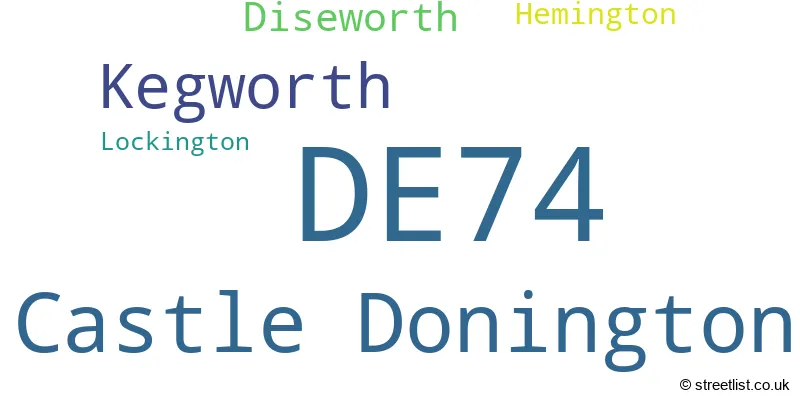
The largest settlement in the DE74 postal code is Castle Donington followed by Kegworth, and Diseworth.
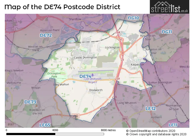
The DE74 Postcode shares a border with DE73 (Chellaston, Melbourne, Ticknall), LE12 (Shepshed, Sileby, Mountsorrel), NG10 (Long Eaton, Sandiacre), NG11 (NOTTINGHAM, Ruddington, Gotham) and DE72 (Borrowash, Breaston, Draycott).
The primary settlement in the DE74 postcode district is Castle Donington, located in the county of Derbyshire, England. Other significant settlements in this postcode district include Diseworth, Hemington, Kegworth, and Lockington, all of which are located in the county of Leicestershire. The most significant post town with the highest number of postcodes in this district is Derby.
For the district DE74, we have data on 2 postcode sectors. Here's a breakdown: The sector DE74 0 is non-geographic. It's often designated for PO Boxes, large organisations, or special services. The sector DE74 2, covers Castle Donington and Kegworth in Leicestershire.
DE74 Postcode Sectors

Map of the DE74 Postcode District
Explore the DE74 postcode district by using our free interactive map.
When it comes to local government, postal geography often disregards political borders. However, for a breakdown in the DE74 District: the district mostly encompasses the North West Leicestershire District (329 postcodes), and finally, the Rushcliffe District (B) area (3 postcodes).
Weather Forecast for DE74
Press Button to Show Forecast for East Midlands Airport
| Time Period | Icon | Description | Temperature | Rain Probability | Wind |
|---|---|---|---|---|---|
| 03:00 to 06:00 | Partly cloudy (night) | 2.0°C (feels like 0.0°C) | 1.00% | ENE 2 mph | |
| 06:00 to 09:00 | Cloudy | 3.0°C (feels like 1.0°C) | 4.00% | NE 4 mph | |
| 09:00 to 12:00 | Partly cloudy (day) | 7.0°C (feels like 5.0°C) | 2.00% | ENE 7 mph | |
| 12:00 to 15:00 | Overcast | 9.0°C (feels like 7.0°C) | 10.00% | ENE 4 mph | |
| 15:00 to 18:00 | Cloudy | 10.0°C (feels like 8.0°C) | 9.00% | E 7 mph | |
| 18:00 to 21:00 | Cloudy | 9.0°C (feels like 7.0°C) | 9.00% | ENE 7 mph | |
| 21:00 to 00:00 | Partly cloudy (night) | 6.0°C (feels like 3.0°C) | 6.00% | ENE 7 mph |
Press Button to Show Forecast for East Midlands Airport
| Time Period | Icon | Description | Temperature | Rain Probability | Wind |
|---|---|---|---|---|---|
| 00:00 to 03:00 | Cloudy | 4.0°C (feels like 2.0°C) | 10.00% | ENE 7 mph | |
| 03:00 to 06:00 | Cloudy | 4.0°C (feels like 1.0°C) | 13.00% | ENE 7 mph | |
| 06:00 to 09:00 | Cloudy | 4.0°C (feels like 2.0°C) | 11.00% | ENE 7 mph | |
| 09:00 to 12:00 | Overcast | 8.0°C (feels like 5.0°C) | 15.00% | ENE 9 mph | |
| 12:00 to 15:00 | Overcast | 9.0°C (feels like 7.0°C) | 23.00% | ENE 11 mph | |
| 15:00 to 18:00 | Overcast | 10.0°C (feels like 8.0°C) | 22.00% | ENE 11 mph | |
| 18:00 to 21:00 | Cloudy | 9.0°C (feels like 7.0°C) | 18.00% | ENE 11 mph | |
| 21:00 to 00:00 | Cloudy | 8.0°C (feels like 5.0°C) | 18.00% | NE 11 mph |
Press Button to Show Forecast for East Midlands Airport
| Time Period | Icon | Description | Temperature | Rain Probability | Wind |
|---|---|---|---|---|---|
| 00:00 to 03:00 | Light rain | 7.0°C (feels like 4.0°C) | 50.00% | NE 9 mph | |
| 03:00 to 06:00 | Light rain | 7.0°C (feels like 4.0°C) | 52.00% | NE 9 mph | |
| 06:00 to 09:00 | Heavy rain | 7.0°C (feels like 5.0°C) | 76.00% | NE 9 mph | |
| 09:00 to 12:00 | Heavy rain | 9.0°C (feels like 7.0°C) | 78.00% | ENE 9 mph | |
| 12:00 to 15:00 | Heavy rain shower (day) | 10.0°C (feels like 8.0°C) | 60.00% | ENE 9 mph | |
| 15:00 to 18:00 | Heavy rain shower (day) | 11.0°C (feels like 9.0°C) | 59.00% | NE 9 mph | |
| 18:00 to 21:00 | Heavy rain shower (day) | 11.0°C (feels like 9.0°C) | 55.00% | ENE 9 mph | |
| 21:00 to 00:00 | Cloudy | 8.0°C (feels like 6.0°C) | 12.00% | ESE 7 mph |
Where is the DE74 Postcode District?
The postcode district DE74 is located in DERBY. It is situated near several towns, including Loughborough to the South East (6.24 miles away), Coalville to the South (6.79 miles away), Ashby-de-la-Zouch to the South West (8.51 miles away), Ilkeston to the North (9.54 miles away), and Nottingham to the North East (12.42 miles away). It is around 104.87 miles away from the center of London.
The district is within the post town of DERBY.
The sector has postcodes within the nation of England.
The DE74 Postcode District is covers the following regions.
- Leicestershire CC and Rutland - Leicestershire, Rutland and Northamptonshire - East Midlands (England)
- Derby - Derbyshire and Nottinghamshire - East Midlands (England)
- South Nottinghamshire - Derbyshire and Nottinghamshire - East Midlands (England)
Postcode Sectors within the DE74 District
| Postcode Sector | Delivery Office |
|---|---|
| DE74 2 | Castle Delivery Officenington Scale Payment Delivery Office |
| DE74 2 | Kegworth Scale Payment Delivery Office |
| DE74 2 | Derby Provincial Delivery Office |
| D | E | 7 | 4 | - | X | X | X |
| D | E | 7 | 4 | Space | Numeric | Letter | Letter |
Current Monthly Rental Prices
| # Bedrooms | Min Price | Max Price | Avg Price |
|---|---|---|---|
| 2 | £750 | £950 | £832 |
| 3 | £925 | £1,100 | £1,007 |
| 4 | £1,300 | £1,650 | £1,463 |
Current House Prices
| # Bedrooms | Min Price | Max Price | Avg Price |
|---|---|---|---|
| 1 | £115,000 | £115,000 | £115,000 |
| 2 | £140,000 | £321,500 | £220,308 |
| 3 | £200,000 | £439,000 | £302,540 |
| 4 | £325,000 | £725,000 | £423,268 |
| 5 | £420,000 | £1,250,000 | £693,529 |
| 6 | £195,000 | £925,000 | £665,000 |
| 7 | £850,000 | £850,000 | £850,000 |
| 8 | £850,000 | £850,000 | £850,000 |
| 12 | £950,000 | £950,000 | £950,000 |
Estate Agents who Operate in the DE74 District
| Logo | Name | Brand Name | Address | Contact Number | Total Properties |
|---|---|---|---|---|---|
 | Castle Donington | Marble Property Services | 23-25 Borough Street Castle Donington DE74 2LA | 01332 327410 | 21 |
 | Long Eaton | Robert Ellis | 5 Derby Road Long Eaton Nottingham NG10 1LU | 0115 647 2153 | 11 |
 | Melbourne | Ashley Adams | 39 Market Place Melbourne DE73 8DS | 01332 215450 | 11 |
 | Loughborough | Newton Fallowell | 3 Swan Street, Loughborough, LE11 5BJ | 01509 275667 | 10 |
 | Kegworth | Lovage Homes Ltd | 27 Market Place Kegworth DE74 2EE | 01509 674140 | 7 |
| Type of Property | 2018 Average | 2018 Sales | 2017 Average | 2017 Sales | 2016 Average | 2016 Sales | 2015 Average | 2015 Sales |
|---|---|---|---|---|---|---|---|---|
| Detached | £297,542 | 103 | £287,530 | 118 | £288,776 | 132 | £258,410 | 147 |
| Semi-Detached | £199,726 | 74 | £179,242 | 57 | £172,182 | 92 | £172,116 | 73 |
| Terraced | £186,356 | 44 | £165,407 | 45 | £173,467 | 53 | £161,490 | 54 |
| Flats | £128,333 | 6 | £122,500 | 11 | £104,215 | 9 | £126,211 | 9 |