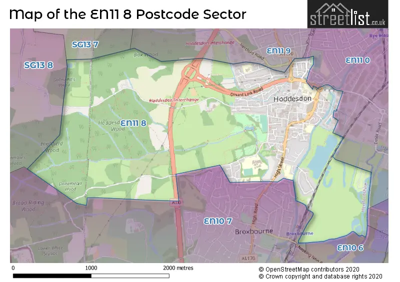
The EN11 8 postcode sector stands on the Hertfordshire and Essex border.
Did you know? According to the 2021 Census, the EN11 8 postcode sector is home to a bustling 6,909 residents!
Given that each sector allows for 400 unique postcode combinations. Letters C, I, K, M, O and V are not allowed in the last two letters of a postcode. With 231 postcodes already in use, this leaves 169 units available.
The EN11 8 postal code covers the settlement of HODDESDON.
The EN11 8 Postcode shares a border with SG13 7 (HERTFORD, Hertford Heath, Hailey), SG13 8 (HERTFORD, Bayford, Brickendon), EN9 2 (WALTHAM ABBEY , NAZEING ), EN10 6 (BROXBOURNE, Turnford, Wormley), EN10 7 (BROXBOURNE), EN11 0 (HODDESDON) and EN11 9 (HODDESDON).
The sector is within the post town of HODDESDON.
EN11 8 is a postcode sector within the EN1 postcode district which is within the EN Enfield postcode area.
The Royal Mail delivery office for the EN11 8 postal sector is the unknown.
The area of the EN11 8 postcode sector is 2.51 square miles which is 6.50 square kilometres or 1,605.68 square acres.
Waterways within the EN11 8 postcode sector include the Woollensbrook, New River.

Map of the EN11 8 Postcode Sector
Explore the EN11 8 postcode sector by using our free interactive map.
| E | N | 1 | 1 | - | 8 | X | X |
| E | N | 1 | 1 | Space | 8 | Letter | Letter |
Official List of Streets
HODDESDON (79 Streets)
Unofficial Streets or Alternative Spellings
HODDESDON
ESSEX ROAD GEDDINGS ROAD MARSH CLOSE OLD ESSEX ROAD STANSTEAD ROAD AMWELL COURT BARCLAY COURT BRAMBLE LANE BREWERY YARD BRIDGEWAYS BURFORD GARDENS BURNSIDE CHARLTON WAY DINANT LINK ROAD ERMINE STREET ESSEX WALK FOXTON MEWS GAS WORKS LANE HANOVER COURT HASELWOOD AVENUE HODDESDON INTERCHANGE JUBILEE TERRACE LEGRA AVENUE LIBRARY COURT LIMES COURT NEW RIVER PATH OXENDON DRIVE PALLETT COURT SPITAL BROOK ST CROSS COURT THE OLD MALTINGS THE SUN ROUNDABOUT WOODSIDE INDUSTRIAL ESTATE YEWLANDS DRIVEBROXBOURNE
PARK LANEHERTFORD
MANGROVE LANEHertford Heath
ELBOW LANESchools and Places of Education Within the EN11 8 Postcode Sector
Robert Barclay Academy
Academy sponsor led
Cock Lane, Hoddesdon, Hertfordshire, EN11 8JY
Head: Mr Ced de la Croix
Ofsted Rating: Good
Inspection: 2023-03-08 (442 days ago)
Website: Visit Robert Barclay Academy Website
Phone: 01992410800
Number of Pupils: 707
Sheredes Primary School
Community school
Benford Road, Hoddesdon, Hertfordshire, EN11 8LL
Head: Mrs Mary Childs
Ofsted Rating: Outstanding
Inspection: 2023-03-08 (442 days ago)
Website: Visit Sheredes Primary School Website
Phone: 01992465154
Number of Pupils: 458
St Catherine's Hoddesdon CofE Primary School
Voluntary controlled school
Haslewood Avenue, Hoddesdon, Hertfordshire, EN11 8HT
Head: Mrs Dorothy Marlow
Ofsted Rating: Good
Inspection: 2023-02-22 (456 days ago)
Website: Visit St Catherine's Hoddesdon CofE Primary School Website
Phone: 01992463214
Number of Pupils: 359
Westfield Community Primary School
Community school
Westfield Road, Hoddesdon, Hertfordshire, EN11 8RA
Head: Mrs Kelly Gradwell
Ofsted Rating: Good
Inspection: 2019-02-26 (1913 days ago)
Website: Visit Westfield Community Primary School Website
Phone: 01992465739
Number of Pupils: 185
House Prices in the EN11 8 Postcode Sector
| Type of Property | 2018 Average | 2018 Sales | 2017 Average | 2017 Sales | 2016 Average | 2016 Sales | 2015 Average | 2015 Sales |
|---|---|---|---|---|---|---|---|---|
| Detached | £616,333 | 12 | £705,577 | 13 | £639,250 | 14 | £640,536 | 14 |
| Semi-Detached | £416,343 | 16 | £407,614 | 16 | £387,072 | 20 | £352,647 | 20 |
| Terraced | £355,365 | 26 | £327,818 | 25 | £325,555 | 37 | £286,616 | 38 |
| Flats | £245,677 | 57 | £229,450 | 81 | £212,523 | 72 | £193,506 | 93 |
Important Postcodes EN11 8 in the Postcode Sector
EN11 8BE is the postcode for The Spotlight, High Street, and Broxbourne Civic Hall, High Street
EN11 8BH is the postcode for Lowewood Museum, Lowewood, High Street
EN11 8BJ is the postcode for Police Station, High Street
EN11 8BN is the postcode for ST CROSS CATHOLIC PRIMARY SCHOOL, UPPER MARSH LANE, HODDESDON, ST CROSS CATHOLIC PRIMARY SCHOOL, UPPER MARSH LANE, and St. Cross RC Primary School, Upper Marsh Lane
EN11 8DP is the postcode for St. Augustine's Catholic Primary School, Riversmead
EN11 8ER is the postcode for Royal Mail, Hoddesdon Delivery Office, Conduit Lane
EN11 8HD is the postcode for Hertfordshire County Council, Hoddesdon Library, 98a High Street
EN11 8HT is the postcode for St. Catherine's Hoddesdon VC CE Primary School, Haslewood Avenue, St. Catherines Hoddesdon Infant School, Haslewood Avenue, JUNIOR BLOCK, St. Catherine's Hoddesdon VC CE Primary School, Haslewood Avenue, and JUNIOR BLOCK, St. Catherine's School, Haslewood Avenue
EN11 8JY is the postcode for BLOCK C, Robert Barclay Academy, Cock Lane, and Robert Barclay Academy, Cock Lane
EN11 8LL is the postcode for LOWER BUILDING, Sheredes Primary School, Benford Road, UPPER BUILDING, Sheredes Primary & Nursery School, Benford Road, UPPER BUILDING, Sheredes Primary School, Benford Road, and LOWER BUILDING, Sheredes Primary & Nursery School, Benford Road
EN11 8RA is the postcode for Westfield Community Primary School, Westfield Road
| The EN11 8 Sector is within these Local Authorities |
|
|---|---|
| The EN11 8 Sector is within these Counties |
|
| The EN11 8 Sector is within these Water Company Areas |
|