The IP13 postcode district is a postal district located in the IP Ipswich postcode area with a population of 19,626 residents according to the 2021 England and Wales Census.
The area of the IP13 postcode district is 101.33 square miles which is 262.45 square kilometres or 64,853.76 acres.
Currently, the IP13 district has about 1158 postcode units spread across 5 geographic postcode sectors.
Given that each sector allows for 400 unique postcode combinations, the district has a capacity of 2,000 postcodes. With 1158 postcodes already in use, this leaves 842 units available.
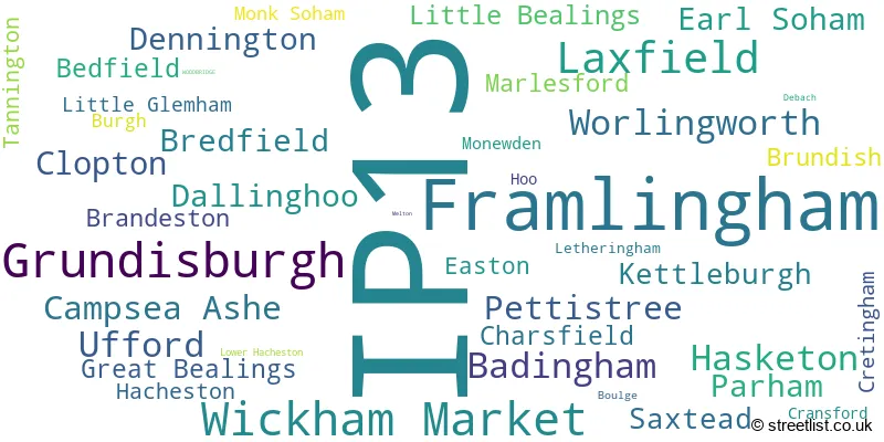
The largest settlement in the IP13 postal code is Framlingham followed by Wickham Market, and Grundisburgh.
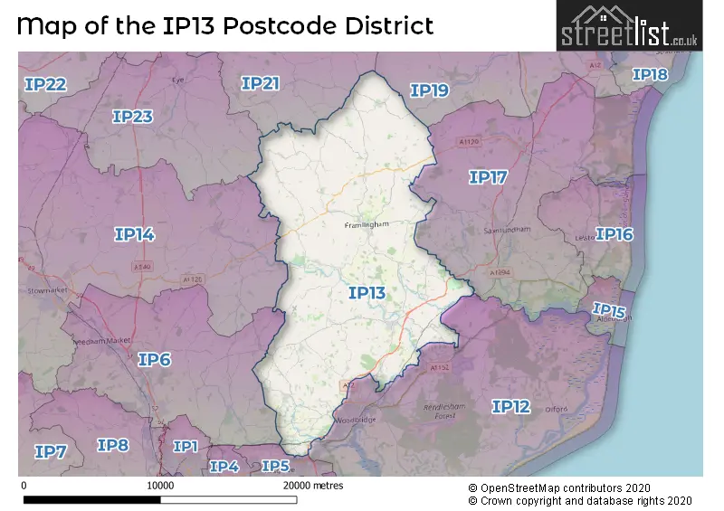
The IP13 Postcode shares a border with IP14 (STOWMARKET, Stowupland, Debenham), IP19 (HALESWORTH, Wenhaston, Holton), IP21 (Stradbroke, Fressingfield, Scole), IP23 (EYE, Gislingham, Thorndon), IP5 (Kesgrave, Martlesham Heath, Rushmere St. Andrew), IP6 (Needham Market, Great Blakenham, Claydon), IP12 (WOODBRIDGE, Melton, Rendlesham) and IP17 (SAXMUNDHAM, Kelsale, Yoxford).
The primary settlement in the IP13 postcode district is Wickham Market, located in the county of Suffolk in England. Other significant settlements within this district include Framlingham, Laxfield, Grundisburgh, and Woodbridge. The main post town for the IP13 district is Woodbridge.
For the district IP13, we have data on 5 postcode sectors. Here's a breakdown: The sector IP13 0, covers Wickham Market and Campsea Ashe and Pettistree and Dallinghoo in Suffolk. The sector IP13 6, covers Grundisburgh and Hasketon and Ufford and Clopton in Suffolk. The sector IP13 7, covers Worlingworth and Earl Soham in Suffolk. The sector IP13 8, covers Laxfield and Badingham and Dennington and Brundish in Suffolk. The sector IP13 9, covers Framlingham and Parham in Suffolk.

Map of the IP13 Postcode District
Explore the IP13 postcode district by using our free interactive map.
When it comes to local government, postal geography often disregards political borders. However, for a breakdown in the IP13 District: the district mostly encompasses the East Suffolk District (999 postcodes), and finally, the Mid Suffolk District area (175 postcodes).
Recent House Sales in IP13
| Date | Price | Address |
|---|---|---|
| 27/09/2023 | £935,000 | Mutton Lane, Brandeston, Woodbridge, IP13 7AR |
| 22/09/2023 | £300,000 | Hitcham Road, Framlingham, Woodbridge, IP13 9FL |
| 18/09/2023 | £343,000 | Ash Road, Lower Hacheston, Woodbridge, IP13 0AA |
| 15/09/2023 | £370,000 | Double Street, Framlingham, Woodbridge, IP13 9BN |
| 14/09/2023 | £975,000 | High Street, Ufford, Woodbridge, IP13 6EG |
| 07/09/2023 | £400,000 | College Road, Framlingham, Woodbridge, IP13 9EU |
| 07/09/2023 | £235,000 | St John Way, Framlingham, Woodbridge, IP13 9FS |
| 05/09/2023 | £282,000 | Lime Close, Wickham Market, Woodbridge, IP13 0RS |
| 01/09/2023 | £485,000 | Parkway, Wickham Market, Woodbridge, IP13 0SS |
| 30/08/2023 | £830,000 | Low Road, Earl Soham, Woodbridge, IP13 7RN |
Weather Forecast for IP13
Press Button to Show Forecast for Framlingham
| Time Period | Icon | Description | Temperature | Rain Probability | Wind |
|---|---|---|---|---|---|
| 18:00 to 21:00 | Cloudy | 8.0°C (feels like 6.0°C) | 4.00% | E 7 mph | |
| 21:00 to 00:00 | Partly cloudy (night) | 4.0°C (feels like 2.0°C) | 1.00% | NE 4 mph |
Press Button to Show Forecast for Framlingham
| Time Period | Icon | Description | Temperature | Rain Probability | Wind |
|---|---|---|---|---|---|
| 00:00 to 03:00 | Cloudy | 5.0°C (feels like 3.0°C) | 7.00% | NE 4 mph | |
| 03:00 to 06:00 | Cloudy | 6.0°C (feels like 4.0°C) | 20.00% | NE 7 mph | |
| 06:00 to 09:00 | Light rain | 6.0°C (feels like 4.0°C) | 63.00% | ENE 7 mph | |
| 09:00 to 12:00 | Light rain | 8.0°C (feels like 5.0°C) | 54.00% | NE 11 mph | |
| 12:00 to 15:00 | Overcast | 10.0°C (feels like 8.0°C) | 14.00% | ENE 11 mph | |
| 15:00 to 18:00 | Overcast | 11.0°C (feels like 9.0°C) | 45.00% | E 9 mph | |
| 18:00 to 21:00 | Cloudy | 10.0°C (feels like 8.0°C) | 14.00% | ENE 9 mph | |
| 21:00 to 00:00 | Heavy rain | 9.0°C (feels like 6.0°C) | 84.00% | NE 11 mph |
Press Button to Show Forecast for Framlingham
| Time Period | Icon | Description | Temperature | Rain Probability | Wind |
|---|---|---|---|---|---|
| 00:00 to 03:00 | Heavy rain | 9.0°C (feels like 6.0°C) | 86.00% | NE 11 mph | |
| 03:00 to 06:00 | Heavy rain | 10.0°C (feels like 8.0°C) | 91.00% | ENE 9 mph | |
| 06:00 to 09:00 | Heavy rain | 10.0°C (feels like 7.0°C) | 86.00% | ESE 11 mph | |
| 09:00 to 12:00 | Heavy rain shower (day) | 11.0°C (feels like 8.0°C) | 62.00% | SW 13 mph | |
| 12:00 to 15:00 | Heavy rain shower (day) | 11.0°C (feels like 8.0°C) | 65.00% | WSW 16 mph | |
| 15:00 to 18:00 | Light rain shower (day) | 10.0°C (feels like 7.0°C) | 42.00% | WSW 13 mph | |
| 18:00 to 21:00 | Cloudy | 10.0°C (feels like 8.0°C) | 13.00% | WSW 9 mph | |
| 21:00 to 00:00 | Partly cloudy (night) | 8.0°C (feels like 5.0°C) | 3.00% | SW 9 mph |
Press Button to Show Forecast for Framlingham
| Time Period | Icon | Description | Temperature | Rain Probability | Wind |
|---|---|---|---|---|---|
| 00:00 to 03:00 | Clear night | 7.0°C (feels like 4.0°C) | 2.00% | SW 7 mph | |
| 03:00 to 06:00 | Clear night | 5.0°C (feels like 3.0°C) | 2.00% | SSW 7 mph | |
| 06:00 to 09:00 | Sunny day | 7.0°C (feels like 5.0°C) | 2.00% | S 7 mph | |
| 09:00 to 12:00 | Partly cloudy (day) | 12.0°C (feels like 10.0°C) | 1.00% | SSW 9 mph | |
| 12:00 to 15:00 | Partly cloudy (day) | 14.0°C (feels like 11.0°C) | 3.00% | S 11 mph | |
| 15:00 to 18:00 | Partly cloudy (day) | 13.0°C (feels like 11.0°C) | 2.00% | SSE 13 mph | |
| 18:00 to 21:00 | Sunny day | 12.0°C (feels like 10.0°C) | 1.00% | SE 9 mph | |
| 21:00 to 00:00 | Clear night | 9.0°C (feels like 7.0°C) | 2.00% | SE 9 mph |
Press Button to Show Forecast for Framlingham
| Time Period | Icon | Description | Temperature | Rain Probability | Wind |
|---|---|---|---|---|---|
| 00:00 to 03:00 | Partly cloudy (night) | 8.0°C (feels like 6.0°C) | 3.00% | SE 7 mph | |
| 03:00 to 06:00 | Partly cloudy (night) | 8.0°C (feels like 6.0°C) | 5.00% | ESE 7 mph | |
| 06:00 to 09:00 | Overcast | 10.0°C (feels like 8.0°C) | 11.00% | ESE 7 mph | |
| 09:00 to 12:00 | Cloudy | 13.0°C (feels like 12.0°C) | 11.00% | SE 9 mph | |
| 12:00 to 15:00 | Cloudy | 15.0°C (feels like 13.0°C) | 10.00% | SE 9 mph | |
| 15:00 to 18:00 | Cloudy | 15.0°C (feels like 13.0°C) | 8.00% | SE 9 mph | |
| 18:00 to 21:00 | Cloudy | 13.0°C (feels like 12.0°C) | 8.00% | ESE 9 mph | |
| 21:00 to 00:00 | Cloudy | 11.0°C (feels like 10.0°C) | 20.00% | E 7 mph |
Where is the IP13 Postcode District?
The data's postcode district, IP13, is located in Woodbridge, a district town. Woodbridge is situated near several neighboring towns. To the east is Saxmundham, which is approximately 7.24 miles away. To the northwest is Eye, located about 10.81 miles from Woodbridge. Ipswich, positioned southwest, is around 12.45 miles away. Halesworth is located northeast, approximately 12.57 miles from Woodbridge. Stowmarket is situated to the west, around 14.45 miles away. Harleston is located to the north, approximately 15.16 miles away, and Felixstowe is located to the south, around 16.18 miles away. Furthermore, Woodbridge is approximately 78.34 miles away from London, serving as a notable distance reference.
The district is within the post town of WOODBRIDGE.
The sector has postcodes within the nation of England.
The IP13 Postcode District is in the Suffolk region of East Anglia within the East of England.
| Postcode Sector | Delivery Office |
|---|---|
| IP13 0 | Wickham Market Scale Payment Delivery Office |
| IP13 6 | Grundisburgh Scale Payment Delivery Office |
| IP13 6 | Woodbridge Delivery Office |
| IP13 7 | Woodbridge Delivery Office |
| IP13 7 | Bedfield Scale Payment Delivery Office |
| IP13 7 | Framlingham Scale Payment Delivery Office |
| IP13 8 | Woodbridge Delivery Office |
| IP13 8 | Framlingham Scale Payment Delivery Office |
| IP13 9 | Woodbridge Delivery Office |
| IP13 9 | Framlingham Scale Payment Delivery Office |
| I | P | 1 | 3 | - | X | X | X |
| I | P | 1 | 3 | Space | Numeric | Letter | Letter |
Tourist Attractions within the Postcode Area
We found 3 visitor attractions within the IP13 postcode area
| Saxtead Green Postmill |
|---|
| Historic Properties |
| Other Historic Property |
| View Saxtead Green Postmill on Google Maps |
| Framlingham Castle |
| Historic Properties |
| Castle / Fort |
| View Framlingham Castle on Google Maps |
| Valley Farm Camargue Horses |
| Farms |
| Farm / Rare Breeds / Farm Animals |
| View Valley Farm Camargue Horses on Google Maps |
Current Monthly Rental Prices
| # Bedrooms | Min Price | Max Price | Avg Price |
|---|---|---|---|
| 2 | £695 | £695 | £695 |
| 3 | £2,250 | £2,250 | £2,250 |
| 4 | £1,550 | £2,475 | £2,013 |
| 5 | £1,900 | £1,900 | £1,900 |
Current House Prices
| # Bedrooms | Min Price | Max Price | Avg Price |
|---|---|---|---|
| £30,000 | £1,400,000 | £403,750 | |
| 1 | £190,000 | £225,000 | £211,250 |
| 2 | £130,000 | £575,000 | £293,483 |
| 3 | £150,000 | £980,000 | £445,961 |
| 4 | £280,000 | £1,250,000 | £628,363 |
| 5 | £500,000 | £2,925,000 | £987,333 |
| 6 | £650,000 | £1,900,000 | £1,110,000 |
| 7 | £950,000 | £1,525,000 | £1,241,667 |
| 8 | £1,050,000 | £1,050,000 | £1,050,000 |
Estate Agents who Operate in the IP13 District
| Logo | Name | Brand Name | Address | Contact Number | Total Properties |
|---|---|---|---|---|---|
 | Framlingham | Clarke & Simpson | Well Close Square, Framlingham, IP13 9DU | 01728 443978 | 42 |
 | Framlingham | Huntingfield Estates | 9 Market Hill, Framlingham, IP13 9AN | 01728 443957 | 22 |
 | Woodbridge | Fenn Wright | Nunns Mill Quayside, Woodbridge, IP12 1BN | 01394 337491 | 15 |
 | Framlingham | William H. Brown | 26 Market Hill, Framlingham, IP13 9AN | 01728 448669 | 12 |
 | Woodbridge | William H. Brown | 16 Church Street Woodbridge IP12 1DH | 01394 331613 | 7 |
- Apsey Green
- Ash Corner
- Ashfield Cum Thorpe
- Ashfield Green
- Badingham
- Bedfield Long Green
- Bedfield
- Boardy Green
- Boot Street
- Brabling Green
- Brandeston
- Bredfield
- Bruisyard
- Bruisyard Street
- Brundish
- Burgh
- Campsea Ashe
- Capon's Green
- Charsfield
- Clopton Corner
- Clopton
- Cransford
- Cretingham
- Dallinghoo
- Debach
- Dennington
- Earl Soham
- Easton
- Framlingham
- Great Bealings
- Great Glemham
- Grundisburgh
- Hacheston
- Hasketon
- Hoo
- Kenton
- Kettleburgh
- Laxfield
- Letheringham
- Little Bealings
- Little Glemham
- Lower Hacheston
- Marlesford
- Martlesham
- Maypole Green
- Melton
- Monewden
- Monk Soham Green
- Newtown
- North Green
- Otley
- Parham
- Pettistree
- Rendlesham
- Saxtead Green
- Saxtead
- Stone Common
- Stratford St Andrew
- Ubbeston
- Ufford
- Wickham Market
- Wilby
- Woodbridge
- Worlingworth
| Type of Property | 2018 Average | 2018 Sales | 2017 Average | 2017 Sales | 2016 Average | 2016 Sales | 2015 Average | 2015 Sales |
|---|---|---|---|---|---|---|---|---|
| Detached | £448,855 | 172 | £458,033 | 189 | £430,046 | 179 | £399,823 | 186 |
| Semi-Detached | £263,275 | 63 | £247,735 | 68 | £241,378 | 88 | £227,702 | 78 |
| Terraced | £241,299 | 84 | £261,993 | 64 | £212,591 | 67 | £221,940 | 59 |
| Flats | £172,510 | 13 | £185,681 | 19 | £150,166 | 9 | £154,722 | 9 |