The IP28 postcode district is a postal district located in the IP Ipswich postcode area with a population of 29,813 residents according to the 2021 England and Wales Census.
The area of the IP28 postcode district is 90.87 square miles which is 235.35 square kilometres or 58,156.02 acres.
Currently, the IP28 district has about 859 postcode units spread across 3 geographic postcode sectors.
Given that each sector allows for 400 unique postcode combinations, the district has a capacity of 1,200 postcodes. With 859 postcodes already in use, this leaves 341 units available.
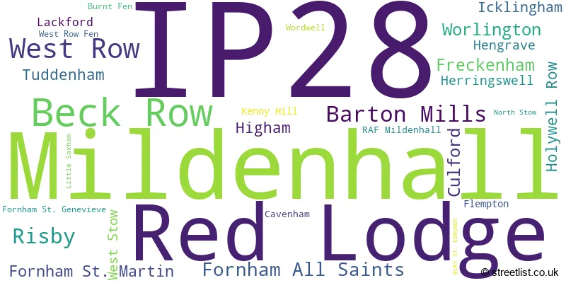
The largest settlement in the IP28 postal code is Mildenhall followed by Red Lodge, and Beck Row.
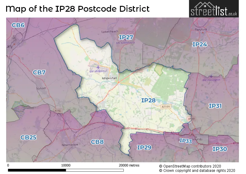
The IP28 Postcode shares a border with IP27 (BRANDON, Lakenheath, RAF Lakenheath), CB7 (Soham, ELY, Fordham), IP31 (Thurston, Stanton, Great Barton), IP24 (THETFORD, Great Hockham, Elveden), IP29 (Barrow, Lawshall, Horringer), IP32 (BURY ST. EDMUNDS), IP33 (BURY ST. EDMUNDS) and CB8 (NEWMARKET, Exning, Wickhambrook).
In the IP28 postcode district, the primary settlement is Mildenhall in Bury St. Edmunds, Suffolk. Other significant settlements in this district include Barton Mills, Cavenham, Culford, Flempton, Fornham All Saints, Fornham St. Genevieve, Fornham St. Martin, Hengrave, Herringswell, Higham, Icklingham, Lackford, Little Saxham, North Stow, Risby, Tuddenham, West Stow, and Wordwell. The county of Suffolk, in England, encompasses these settlements. The most significant postal town in this district is Bury St. Edmunds.
For the district IP28, we have data on 5 postcode sectors. Here's a breakdown: The sector IP28 1 is non-geographic. It's often designated for PO Boxes, large organisations, or special services. The sector IP28 6, covers Barton Mills and Risby in Suffolk. The sector IP28 7, covers Mildenhall in Suffolk. The sector IP28 8, covers Red Lodge and Beck Row and West Row in Suffolk. The sector IP28 9 is non-geographic. It's often designated for PO Boxes, large organisations, or special services.

Map of the IP28 Postcode District
Explore the IP28 postcode district by using our free interactive map.
When it comes to local government, postal geography often disregards political borders. However, for a breakdown in the IP28 District: the district mostly encompasses the West Suffolk District area with a total of 864 postcodes.
Recent House Sales in IP28
| Date | Price | Address |
|---|---|---|
| 10/10/2023 | £1,500 | Crooked Chimney Row, West Stow, Bury St Edmunds, IP28 6HB |
| 10/10/2023 | £295,000 | Church Gardens, West Row, Bury St Edmunds, IP28 8PG |
| 02/10/2023 | £315,000 | Woodlands Way, Mildenhall, Bury St Edmunds, IP28 7JF |
| 02/10/2023 | £157,500 | Pigeon Lane, Fornham All Saints, Bury St Edmunds, IP28 6JP |
| 26/09/2023 | £900,000 | Upper Green, Higham, Bury St Edmunds, IP28 6PA |
| 22/09/2023 | £232,500 | The Presidents, Beck Row, Bury St Edmunds, IP28 8HS |
| 22/09/2023 | £380,000 | Birkdale Court, Fornham St Martin, Bury St Edmunds, IP28 6XF |
| 21/09/2023 | £365,000 | Barleycorn Way, Beck Row, Bury St Edmunds, IP28 8YQ |
| 19/09/2023 | £200,000 | Pembroke Close, Mildenhall, Bury St Edmunds, IP28 7NA |
| 19/09/2023 | £239,497 | Lamble Close, Beck Row, Bury St Edmunds, IP28 8DB |
Weather Forecast for IP28
Press Button to Show Forecast for Cavenham
| Time Period | Icon | Description | Temperature | Rain Probability | Wind |
|---|---|---|---|---|---|
| 03:00 to 06:00 | Clear night | 0.0°C (feels like -2.0°C) | 0.00% | NW 4 mph | |
| 06:00 to 09:00 | Sunny day | 2.0°C (feels like 0.0°C) | 1.00% | NNW 4 mph | |
| 09:00 to 12:00 | Partly cloudy (day) | 8.0°C (feels like 6.0°C) | 1.00% | NE 4 mph | |
| 12:00 to 15:00 | Cloudy | 10.0°C (feels like 9.0°C) | 6.00% | ENE 4 mph | |
| 15:00 to 18:00 | Overcast | 10.0°C (feels like 9.0°C) | 10.00% | ENE 4 mph | |
| 18:00 to 21:00 | Cloudy | 8.0°C (feels like 6.0°C) | 8.00% | E 7 mph | |
| 21:00 to 00:00 | Cloudy | 5.0°C (feels like 3.0°C) | 9.00% | E 4 mph |
Press Button to Show Forecast for Cavenham
| Time Period | Icon | Description | Temperature | Rain Probability | Wind |
|---|---|---|---|---|---|
| 00:00 to 03:00 | Partly cloudy (night) | 4.0°C (feels like 1.0°C) | 7.00% | ENE 7 mph | |
| 03:00 to 06:00 | Cloudy | 3.0°C (feels like 0.0°C) | 13.00% | ENE 7 mph | |
| 06:00 to 09:00 | Cloudy | 5.0°C (feels like 2.0°C) | 16.00% | ENE 7 mph | |
| 09:00 to 12:00 | Cloudy | 9.0°C (feels like 7.0°C) | 17.00% | ENE 9 mph | |
| 12:00 to 15:00 | Overcast | 11.0°C (feels like 9.0°C) | 18.00% | E 9 mph | |
| 15:00 to 18:00 | Overcast | 12.0°C (feels like 10.0°C) | 19.00% | E 9 mph | |
| 18:00 to 21:00 | Cloudy | 10.0°C (feels like 8.0°C) | 13.00% | ENE 11 mph | |
| 21:00 to 00:00 | Light rain | 8.0°C (feels like 6.0°C) | 46.00% | NE 11 mph |
Press Button to Show Forecast for Cavenham
| Time Period | Icon | Description | Temperature | Rain Probability | Wind |
|---|---|---|---|---|---|
| 00:00 to 03:00 | Light rain | 9.0°C (feels like 6.0°C) | 48.00% | ENE 11 mph | |
| 03:00 to 06:00 | Heavy rain | 9.0°C (feels like 7.0°C) | 75.00% | ESE 11 mph | |
| 06:00 to 09:00 | Cloudy | 10.0°C (feels like 8.0°C) | 22.00% | SE 11 mph | |
| 09:00 to 12:00 | Light rain shower (day) | 11.0°C (feels like 9.0°C) | 45.00% | SSE 11 mph | |
| 12:00 to 15:00 | Heavy rain shower (day) | 12.0°C (feels like 10.0°C) | 61.00% | S 11 mph | |
| 15:00 to 18:00 | Light rain shower (day) | 13.0°C (feels like 10.0°C) | 41.00% | SW 11 mph | |
| 18:00 to 21:00 | Light rain shower (day) | 12.0°C (feels like 10.0°C) | 36.00% | WSW 11 mph | |
| 21:00 to 00:00 | Partly cloudy (night) | 9.0°C (feels like 7.0°C) | 8.00% | SW 9 mph |
Where is the IP28 Postcode District?
The postcode district 'IP28' is located in the town of Bury St. Edmunds. Bury St. Edmunds is situated in Suffolk County, and it is surrounded by several nearby towns. To the north, there is Brandon, which is approximately 7.6 miles away. To the southwest, there is Newmarket, located about 9.3 miles away. Thetford is situated to the northeast, around 10.4 miles away. Ely is found to the west, at a distance of approximately 14.5 miles. Haverhill is located to the south, and it is approximately 17.9 miles away. Stowmarket is situated to the southeast, around 20.3 miles away. Lastly, Downham Market is located to the northwest, at a distance of approximately 20.5 miles. In terms of the center of London, Bury St. Edmunds is situated roughly 63.8 miles away.
The district is within the post town of BURY ST. EDMUNDS.
The sector has postcodes within the nation of England.
The IP28 Postcode District is in the region of within the .
| Postcode Sector | Delivery Office |
|---|---|
| IP28 6 | Bury St. Edmunds Delivery Office |
| IP28 6 | Higham Scale Payment Delivery Office |
| IP28 6 | Mildenhall Delivery Office |
| IP28 7 | Mildenhall Delivery Office |
| IP28 8 | Mildenhall Delivery Office |
| IP28 8 | Bury St. Edmunds Delivery Office |
| IP28 8 | West Row Scale Payment Delivery Office |
| I | P | 2 | 8 | - | X | X | X |
| I | P | 2 | 8 | Space | Numeric | Letter | Letter |
Current Monthly Rental Prices
| # Bedrooms | Min Price | Max Price | Avg Price |
|---|---|---|---|
| £1,800 | £1,800 | £1,800 | |
| 1 | £480 | £1,350 | £992 |
| 2 | £1,050 | £1,535 | £1,188 |
| 3 | £1,000 | £2,000 | £1,268 |
| 4 | £1,220 | £2,800 | £1,764 |
| 5 | £1,535 | £3,000 | £2,190 |
Current House Prices
| # Bedrooms | Min Price | Max Price | Avg Price |
|---|---|---|---|
| £120,000 | £550,000 | £308,000 | |
| 1 | £199,995 | £285,000 | £242,498 |
| 2 | £90,000 | £400,000 | £217,433 |
| 3 | £140,000 | £845,000 | £321,691 |
| 4 | £200,000 | £925,000 | £425,664 |
| 5 | £345,000 | £1,000,000 | £564,412 |
| 6 | £1,000,000 | £1,000,000 | £1,000,000 |
| 7 | £875,000 | £875,000 | £875,000 |
| 10 | £1,500,000 | £1,750,000 | £1,625,000 |
Estate Agents who Operate in the IP28 District
| Logo | Name | Brand Name | Address | Contact Number | Total Properties |
|---|---|---|---|---|---|
 | Mildenhall | Balmforth | 22-26 High Street, Mildenhall, IP28 7EQ | 01638 597109 | 97 |
 | Mildenhall | Henleys | 16 High Street Mildenhall IP28 7EQ | 01638 597091 | 40 |
 | Mildenhall | Shires Residential | 4 New Street Mildenhall IP28 7EN | 01638 597108 | 26 |
 | Lakenheath | baseLETS | 5 Shopping Centre Earls Field Raf Lakenheath IP27 9RX | 01842 771042 | 13 |
 | Wiltshire | Quickmove Properties | 15 Interface Business Park, Binknoll Lane, Royal Wootton Bassett, SN4 8SY | 01793 540551 | 12 |
- Barton Mills
- Beck Row
- Bury St Edmunds
- Cavenham
- Culford
- Elveden
- Flempton
- Fornham All Saints
- Fornham St Genevieve
- Fornham St Martin
- Freckenham
- Hengrave
- Higham
- Holywell Row
- Icklingham
- Ingham
- Isleham
- Kennett
- Kenny Hill
- Lackford
- Mildenhall
- Prickwillow
- Red Lodge
- Risby
- Tuddenham
- Undley
- West Row
- West Stow
- Wilde Street
- Worlington
| Type of Property | 2018 Average | 2018 Sales | 2017 Average | 2017 Sales | 2016 Average | 2016 Sales | 2015 Average | 2015 Sales |
|---|---|---|---|---|---|---|---|---|
| Detached | £344,287 | 214 | £321,762 | 237 | £312,774 | 205 | £280,148 | 247 |
| Semi-Detached | £243,174 | 150 | £223,182 | 151 | £203,349 | 174 | £192,890 | 180 |
| Terraced | £193,965 | 100 | £192,053 | 133 | £177,056 | 155 | £164,101 | 168 |
| Flats | £158,708 | 24 | £138,296 | 43 | £132,587 | 48 | £144,504 | 53 |