The LS9 postcode district is a postal district located in the LS Leeds postcode area with a population of 43,563 residents according to the 2021 England and Wales Census.
The area of the LS9 postcode district is 3.82 square miles which is 9.88 square kilometres or 2,441.90 acres.
Currently, the LS9 district has about 874 postcode units spread across 5 geographic postcode sectors.
Given that each sector allows for 400 unique postcode combinations, the district has a capacity of 2,000 postcodes. With 874 postcodes already in use, this leaves 1126 units available.
The largest settlements in the LS9 postal code are LEEDS and Cross Green.
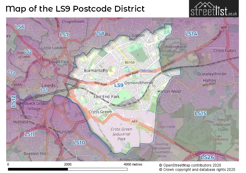
The LS9 Postcode shares a border with LS10 (LEEDS, Hunslet, Middleton), LS15 (LEEDS, Barwick In Elmet, Scholes), LS2 (LEEDS), LS7 (LEEDS, Chapel Allerton), LS8 (LEEDS, Roundhay) and LS14 (LEEDS, Seacroft, Thorner).
The primary settlement in the LS9 postcode district is Leeds, which is located in the county of West Yorkshire, England. Other significant settlements within the LS9 postcode district include Cross Green. Leeds is also the main post town for the LS9 district.
For the district LS9, we have data on 6 postcode sectors. Here's a breakdown: The sector LS9 0, covers Leeds in West Yorkshire. The sector LS9 1 is non-geographic. It's often designated for PO Boxes, large organisations, or special services. The sector LS9 6, covers Leeds in West Yorkshire. The sector LS9 7, covers Leeds in West Yorkshire. The sector LS9 8, covers Leeds in West Yorkshire. The sector LS9 9, covers Leeds in West Yorkshire.

Map of the LS9 Postcode District
Explore the LS9 postcode district by using our free interactive map.
When it comes to local government, postal geography often disregards political borders. However, for a breakdown in the LS9 District: the district mostly encompasses the Leeds District (B) area with a total of 881 postcodes.
Recent House Sales in LS9
| Date | Price | Address |
|---|---|---|
| 24/10/2023 | £165,000 | Haslewood Drive, Leeds, LS9 7PT |
| 13/10/2023 | £71,500 | Neville Parade, Leeds, LS9 0LD |
| 13/10/2023 | £450,000 | East Street, Leeds, LS9 8BB |
| 06/10/2023 | £180,000 | Pontefract Lane, Leeds, LS9 9HW |
| 02/10/2023 | £74,000 | Compton Avenue, Leeds, LS9 7BW |
| 29/09/2023 | £70,000 | Marsh Lane, Leeds, LS9 8AY |
| 27/09/2023 | £75,250 | Strathmore View, Leeds, LS9 6AZ |
| 18/09/2023 | £80,000 | Foundry Approach, Leeds, LS9 6BT |
| 08/09/2023 | £120,000 | Coldcotes Avenue, Leeds, LS9 6NA |
| 08/09/2023 | £110,000 | St Hildas Place, Leeds, LS9 0BX |
Weather Forecast for LS9
Press Button to Show Forecast for Osmondthorpe
| Time Period | Icon | Description | Temperature | Rain Probability | Wind |
|---|---|---|---|---|---|
| 00:00 to 03:00 | Partly cloudy (night) | 3.0°C (feels like 2.0°C) | 1.00% | N 4 mph | |
| 03:00 to 06:00 | Clear night | 2.0°C (feels like 0.0°C) | 1.00% | N 4 mph | |
| 06:00 to 09:00 | Partly cloudy (day) | 3.0°C (feels like 0.0°C) | 2.00% | N 7 mph | |
| 09:00 to 12:00 | Cloudy | 7.0°C (feels like 5.0°C) | 5.00% | NE 4 mph | |
| 12:00 to 15:00 | Overcast | 8.0°C (feels like 7.0°C) | 10.00% | NE 4 mph | |
| 15:00 to 18:00 | Cloudy | 9.0°C (feels like 8.0°C) | 7.00% | ENE 4 mph | |
| 18:00 to 21:00 | Partly cloudy (day) | 8.0°C (feels like 6.0°C) | 6.00% | ENE 7 mph | |
| 21:00 to 00:00 | Cloudy | 5.0°C (feels like 3.0°C) | 8.00% | E 7 mph |
Press Button to Show Forecast for Osmondthorpe
| Time Period | Icon | Description | Temperature | Rain Probability | Wind |
|---|---|---|---|---|---|
| 00:00 to 03:00 | Cloudy | 4.0°C (feels like 3.0°C) | 8.00% | NNE 4 mph | |
| 03:00 to 06:00 | Cloudy | 3.0°C (feels like 2.0°C) | 7.00% | NE 4 mph | |
| 06:00 to 09:00 | Partly cloudy (day) | 4.0°C (feels like 2.0°C) | 7.00% | NE 4 mph | |
| 09:00 to 12:00 | Cloudy | 8.0°C (feels like 6.0°C) | 11.00% | E 7 mph | |
| 12:00 to 15:00 | Overcast | 10.0°C (feels like 8.0°C) | 15.00% | E 9 mph | |
| 15:00 to 18:00 | Overcast | 10.0°C (feels like 8.0°C) | 21.00% | E 9 mph | |
| 18:00 to 21:00 | Cloudy | 9.0°C (feels like 7.0°C) | 17.00% | ENE 9 mph | |
| 21:00 to 00:00 | Cloudy | 7.0°C (feels like 4.0°C) | 17.00% | NE 7 mph |
Press Button to Show Forecast for Osmondthorpe
| Time Period | Icon | Description | Temperature | Rain Probability | Wind |
|---|---|---|---|---|---|
| 00:00 to 03:00 | Light rain | 6.0°C (feels like 3.0°C) | 45.00% | NNE 9 mph | |
| 03:00 to 06:00 | Light rain | 6.0°C (feels like 3.0°C) | 48.00% | NNE 11 mph | |
| 06:00 to 09:00 | Heavy rain | 7.0°C (feels like 4.0°C) | 75.00% | NNE 11 mph | |
| 09:00 to 12:00 | Heavy rain | 8.0°C (feels like 5.0°C) | 79.00% | NNE 13 mph | |
| 12:00 to 15:00 | Light rain | 9.0°C (feels like 6.0°C) | 58.00% | NNE 13 mph | |
| 15:00 to 18:00 | Heavy rain | 10.0°C (feels like 7.0°C) | 75.00% | N 11 mph | |
| 18:00 to 21:00 | Light rain | 9.0°C (feels like 8.0°C) | 46.00% | NNE 7 mph | |
| 21:00 to 00:00 | Partly cloudy (night) | 8.0°C (feels like 6.0°C) | 9.00% | SE 7 mph |
Where is the LS9 Postcode District?
The postcode district LS9 is located in the town of Leeds. It is related to nearby towns such as Pudsey to the West, Normanton to the South East, Batley to the South West, and Ossett to the South. The distance of LS9 to London is approximately 168.5 miles.
The district is within the post town of LEEDS.
The sector has postcodes within the nation of England.
The LS9 Postcode District is in the Leeds region of West Yorkshire within the Yorkshire and The Humber.
| Postcode Sector | Delivery Office |
|---|---|
| LS9 0 | York Road Delivery Office |
| LS9 6 | York Road Delivery Office |
| LS9 7 | York Road Delivery Office |
| LS9 8 | York Road Delivery Office |
| LS9 9 | York Road Delivery Office |
| L | S | 9 | - | X | X | X |
| L | S | 9 | Space | Numeric | Letter | Letter |
Tourist Attractions within the Postcode Area
We found 1 visitor attractions within the LS9 postcode area
| Thackray Museum |
|---|
| Museums & Art Galleries |
| Museum and / or Art Gallery |
| View Thackray Museum on Google Maps |
Current Monthly Rental Prices
| # Bedrooms | Min Price | Max Price | Avg Price |
|---|---|---|---|
| £595 | £4,167 | £1,697 | |
| 1 | £450 | £1,000 | £789 |
| 2 | £725 | £1,800 | £1,117 |
| 3 | £750 | £1,350 | £1,043 |
| 4 | £1,100 | £2,500 | £1,850 |
| 14 | £607 | £607 | £607 |
Current House Prices
| # Bedrooms | Min Price | Max Price | Avg Price |
|---|---|---|---|
| £80,000 | £7,000,000 | £1,275,833 | |
| 1 | £80,000 | £245,000 | £124,933 |
| 2 | £75,850 | £314,000 | £167,557 |
| 3 | £95,000 | £570,000 | £206,658 |
| 4 | £135,000 | £595,000 | £216,667 |
| 8 | £500,000 | £500,000 | £500,000 |
Estate Agents who Operate in the LS9 District
| Logo | Name | Brand Name | Address | Contact Number | Total Properties |
|---|---|---|---|---|---|
 | Leeds | North Property Group | North Property Group, One Brewery Wharf, Leeds, West Yorkshire, LS10 1GX | 0113 519 7501 | 23 |
 | Leeds | Care 4 Properties | 188A Roundhay Road, Leeds, LS8 5PL | 0113 519 3965 | 17 |
 | Leeds | Linley & Simpson | 1 Dock Street Leeds LS10 1NB | 0113 519 1008 | 15 |
 | Crossgates | Manning Stainton | 62 Austhorpe Road, Leeds, LS15 8DX | 0113 519 1494 | 11 |
 | Leeds City | Martin & Co | 24-28 Bridge End Leeds LS1 4DJ | 0113 519 4987 | 10 |
| Type of Property | 2018 Average | 2018 Sales | 2017 Average | 2017 Sales | 2016 Average | 2016 Sales | 2015 Average | 2015 Sales |
|---|---|---|---|---|---|---|---|---|
| Detached | £204,500 | 4 | £139,998 | 8 | £117,500 | 4 | £91,000 | 4 |
| Semi-Detached | £119,352 | 97 | £126,982 | 129 | £99,080 | 83 | £100,624 | 88 |
| Terraced | £82,381 | 267 | £80,899 | 270 | £73,906 | 271 | £67,430 | 236 |
| Flats | £142,582 | 151 | £137,686 | 337 | £130,752 | 239 | £125,863 | 218 |