The M41 9 postcode sector is within the county of Greater Manchester.
Did you know? According to the 2021 Census, the M41 9 postcode sector is home to a bustling 9,424 residents!
Given that each sector allows for 400 unique postcode combinations. Letters C, I, K, M, O and V are not allowed in the last two letters of a postcode. With 218 postcodes already in use, this leaves 182 units available.
The M41 9 postal code covers the settlement of Urmston.
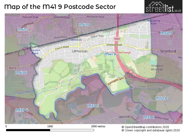
The M41 9 Postcode shares a border with M31 4 (Partington, Carrington), M32 8 (Stretford), M32 9 (Stretford), M33 5 (SALE), M41 5 (Urmston), M41 6 (Urmston) and M41 0 (Urmston).
The sector is within the post town of MANCHESTER.
M41 9 is a postcode sector within the M41 postcode district which is within the M Manchester postcode area.
The Royal Mail delivery office for the M41 9 postal sector is the Urmston Delivery Office.
The area of the M41 9 postcode sector is 1.39 square miles which is 3.59 square kilometres or 886.77 square acres.
The M41 9 postcode sector is crossed by the M60 motorway.
Waterways within the M41 9 postcode sector include the River Mersey.

Map of the M41 9 Postcode Sector
Explore the M41 9 postcode sector by using our free interactive map.
| M | 4 | 1 | - | 9 | X | X |
| M | 4 | 1 | Space | 9 | Letter | Letter |
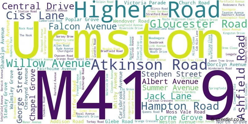
Official List of Streets
Urmston (125 Streets)
Unofficial Streets or Alternative Spellings
Urmston
BALMORAL ROAD GLADSTONE ROAD MINEHEAD AVENUE PORLOCK ROAD RAILWAY ROADStretford
BRADFIELD ROAD DERBYSHIRE LANE WEST MOSS PARK ROAD URMSTON LANE BRADSHAW BRIDGE CARISBROOKE AVENUE CARRINGTON SPUR CARRINGTON SPUR ROUNDABOUT EMON TREE GROVE HATRO COURT MANOR PARK MILLENIUM FOOTBRIDGE MULBERRY COURT ST CLEMENT COURTWeather Forecast for M41 9
Press Button to Show Forecast for Urmston
| Time Period | Icon | Description | Temperature | Rain Probability | Wind |
|---|---|---|---|---|---|
| 18:00 to 21:00 | Overcast | 9.0°C (feels like 7.0°C) | 9.00% | ENE 11 mph | |
| 21:00 to 00:00 | Cloudy | 8.0°C (feels like 5.0°C) | 4.00% | ENE 9 mph |
Press Button to Show Forecast for Urmston
| Time Period | Icon | Description | Temperature | Rain Probability | Wind |
|---|---|---|---|---|---|
| 00:00 to 03:00 | Cloudy | 7.0°C (feels like 4.0°C) | 6.00% | NE 9 mph | |
| 03:00 to 06:00 | Cloudy | 6.0°C (feels like 3.0°C) | 54.00% | NNE 11 mph | |
| 06:00 to 09:00 | Heavy rain | 6.0°C (feels like 3.0°C) | 86.00% | N 9 mph | |
| 09:00 to 12:00 | Heavy rain | 6.0°C (feels like 3.0°C) | 86.00% | NNW 9 mph | |
| 12:00 to 15:00 | Light rain | 7.0°C (feels like 4.0°C) | 56.00% | WNW 11 mph | |
| 15:00 to 18:00 | Cloudy | 9.0°C (feels like 6.0°C) | 41.00% | WNW 11 mph | |
| 18:00 to 21:00 | Partly cloudy (day) | 10.0°C (feels like 7.0°C) | 4.00% | W 11 mph | |
| 21:00 to 00:00 | Partly cloudy (night) | 8.0°C (feels like 5.0°C) | 1.00% | SW 7 mph |
Press Button to Show Forecast for Urmston
| Time Period | Icon | Description | Temperature | Rain Probability | Wind |
|---|---|---|---|---|---|
| 00:00 to 03:00 | Partly cloudy (night) | 6.0°C (feels like 4.0°C) | 1.00% | SSW 7 mph | |
| 03:00 to 06:00 | Cloudy | 5.0°C (feels like 3.0°C) | 38.00% | S 9 mph | |
| 06:00 to 09:00 | Cloudy | 6.0°C (feels like 4.0°C) | 7.00% | S 9 mph | |
| 09:00 to 12:00 | Partly cloudy (day) | 10.0°C (feels like 8.0°C) | 7.00% | S 13 mph | |
| 12:00 to 15:00 | Light rain shower (day) | 13.0°C (feels like 10.0°C) | 34.00% | S 16 mph | |
| 15:00 to 18:00 | Cloudy | 14.0°C (feels like 11.0°C) | 14.00% | S 16 mph | |
| 18:00 to 21:00 | Cloudy | 13.0°C (feels like 11.0°C) | 12.00% | S 13 mph | |
| 21:00 to 00:00 | Cloudy | 11.0°C (feels like 9.0°C) | 6.00% | SSE 11 mph |
Press Button to Show Forecast for Urmston
| Time Period | Icon | Description | Temperature | Rain Probability | Wind |
|---|---|---|---|---|---|
| 00:00 to 03:00 | Cloudy | 10.0°C (feels like 8.0°C) | 5.00% | SSE 11 mph | |
| 03:00 to 06:00 | Partly cloudy (night) | 9.0°C (feels like 7.0°C) | 3.00% | SE 11 mph | |
| 06:00 to 09:00 | Sunny day | 9.0°C (feels like 7.0°C) | 2.00% | SE 11 mph | |
| 09:00 to 12:00 | Sunny day | 13.0°C (feels like 11.0°C) | 2.00% | SE 13 mph | |
| 12:00 to 15:00 | Cloudy | 16.0°C (feels like 13.0°C) | 7.00% | SE 16 mph | |
| 15:00 to 18:00 | Cloudy | 17.0°C (feels like 14.0°C) | 10.00% | SE 13 mph | |
| 18:00 to 21:00 | Light rain shower (day) | 15.0°C (feels like 14.0°C) | 31.00% | ESE 9 mph | |
| 21:00 to 00:00 | Partly cloudy (night) | 13.0°C (feels like 12.0°C) | 7.00% | E 7 mph |
Press Button to Show Forecast for Urmston
| Time Period | Icon | Description | Temperature | Rain Probability | Wind |
|---|---|---|---|---|---|
| 00:00 to 03:00 | Cloudy | 12.0°C (feels like 10.0°C) | 9.00% | E 7 mph | |
| 03:00 to 06:00 | Cloudy | 11.0°C (feels like 10.0°C) | 10.00% | E 7 mph | |
| 06:00 to 09:00 | Cloudy | 11.0°C (feels like 10.0°C) | 15.00% | ENE 7 mph | |
| 09:00 to 12:00 | Cloudy | 14.0°C (feels like 13.0°C) | 14.00% | E 7 mph | |
| 12:00 to 15:00 | Cloudy | 16.0°C (feels like 15.0°C) | 16.00% | E 9 mph | |
| 15:00 to 18:00 | Cloudy | 18.0°C (feels like 16.0°C) | 17.00% | E 7 mph | |
| 18:00 to 21:00 | Cloudy | 17.0°C (feels like 15.0°C) | 13.00% | NE 7 mph | |
| 21:00 to 00:00 | Cloudy | 14.0°C (feels like 12.0°C) | 11.00% | NE 7 mph |
Schools and Places of Education Within the M41 9 Postcode Sector
Highfield Primary School
Community school
Bridgenorth Avenue, Manchester, Greater Manchester, M41 9PA
Head: Mrs Claire Brown
Ofsted Rating: Good
Inspection: 2023-02-23 (429 days ago)
Website: Visit Highfield Primary School Website
Phone: 01617486096
Number of Pupils: 312
House Prices in the M41 9 Postcode Sector
| Type of Property | 2018 Average | 2018 Sales | 2017 Average | 2017 Sales | 2016 Average | 2016 Sales | 2015 Average | 2015 Sales |
|---|---|---|---|---|---|---|---|---|
| Detached | £397,864 | 11 | £386,000 | 12 | £334,675 | 20 | £277,641 | 11 |
| Semi-Detached | £285,401 | 88 | £272,612 | 82 | £246,920 | 83 | £221,775 | 81 |
| Terraced | £212,962 | 41 | £229,121 | 28 | £191,849 | 45 | £175,884 | 38 |
| Flats | £151,309 | 17 | £131,607 | 14 | £111,125 | 20 | £115,534 | 39 |
Important Postcodes M41 9 in the Postcode Sector
M41 9AA is the postcode for Royal Mail, Urmston Delivery Office, 9 Higher Road
M41 9HE is the postcode for Manor House Resource Centre, 5 Queens Road
M41 9JS is the postcode for Gloucester House Medical Centre, 17 Station Road
M41 9LH is the postcode for Trafford Social Services, Meadowside, Torbay Road
M41 9PA is the postcode for Highfield Primary School, Bridgenorth Avenue
M41 9PD is the postcode for St. Antony's Catholic College, Bradfield Road, and St AntonyG��s Roman Catholic School, Bradfield Road, Urmston
| The M41 9 Sector is within these Local Authorities |
|
|---|---|
| The M41 9 Sector is within these Counties |
|
| The M41 9 Sector is within these Water Company Areas |
|